This earthcache deals with the factors which may contribute to a reversing river.
You need to visit this earthcache when the river is not frozen in order to complete this earthcache. It may be frozen if there has been a long cold spell during the winter.
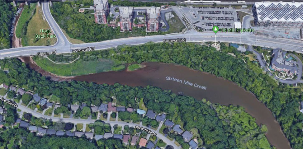
Best parking can probably be found across the street at the Oakville GO station.
To get to the river, follow the path and go down the steep bank where you see an opening in the trees near the posted coordinates or walk a bit further where it is flat under the Speers Rd bridge, however that would require a further wade within the water. Beware of giant hogweed which may be present between these 2 points and know that the city sprays there.
In order to log your find, determine the following:
1) Indicate the day and specific time of day that you visited this location.
2) What is the current weather conditions?
3) Observations and Estimates
a) At the time of your visit, does the river appear to be reversing? When facing the river with your back towards Cornwall Rd to the north, is the river flowing left (towards Lake Ontario) or right (upstream towards Cornwall Rd)? If it is flowing to the right, then it is reversing.
b) Estimate the speed at which the river is flowing in Meters per Second and in which direction.
c) Looking to the middle of the river, can you see the riverbed under the water?
d) Is the river cloudy or clear?
e) What colour does the water appear as?
4) Measurements
a) Using a stick, pick 2 points along the river at least 10 meters apart and measure the actual speed of the river.
b) Which direction did your stick travel?
c) How far across the river can you walk without getting your feet wet (assuming you are just wearing shoes)? The answer many be 0 most times of the year.
d) How deep is the water in the middle of the river (at posted coordinates).
5) Do your observations from #3 above differ from your actual measurements you took from #4? Give some analysis in your own words.
Over the years we have witnessed the reversing river of 16 Mile Creek on numerous occasions. The first time I saw this phenomenon here, I had to go down and check it out and have been curious about it ever since. We even threw a stick in and were surprised by what we saw. Now it's your turn to visit here and hopefully witness the reversing river, which may or may not be happening at your time of visit. We seem to notice it more often in the afternoons when it does occur, or that just happens to be the time of day which we are here most often.
Sixteen Mile Creek is a river located in Halton Region. It is in the Great Lakes Basin, and flows from the Niagara Escarpment through the towns of Milton and Oakville to Lake Ontario. It was previously known to the Mississauga Indians in their language as Ne-sauga y-onk or niizhozaagiwan ("having two outlets") and to the French as Rivière de Gravois ("gravelly river"). Like many creeks draining into Lake Ontario, Sixteen Mile Creek has cut a deep valley that is home to a broad range of wildlife. The forest contains tree species typical of the Carolinian forest habitat, although since this is close to the northern limit of this zone, some are poorly represented. The total area of the drainage basin is 372 square kilometres.
Rivers are shaped by the geography around them and, through their own flow and movement, change and shape the landscape around them. Rivers are a vital part of many ecosystems and are an integral part of the natural world that influences everything from travel to food, water cycles and underground aquifers and more. The rivers we know today weren’t always as we know them today, however; the flow, shapes and locations of many of our modern day rivers were once very different.
Rivers haven’t always flowed in the same directions as they do today. Rivers have a tendency to change with the landscape as mountains are formed, sediment is deposited, and landforms drift apart. Rivers that were once dominant parts of the landscape are now gone, dried and left with few markers of their existence.
Rivers have a tendency to change, as we’ve seen. Rivers that continue to flow can sometimes reverse their directions due to natural and man-made factors including erosion, weather, the earth's gravitational pull, natural disasters, and city planning for a variety of reasons. Some rivers that have changed for natural reasons include the Amazon and the Mississippi, bringing them into the group of many rivers that have switched direction (and sometimes switched again).
If you are ever in the east of Croatia, visit the town of Vinkovci, where you will find the Bosut River and experience something very similar to what you may see here on 16 Mile Creek.