


Montaña Roja es un volcán al sur de la isla de Lanzarote en las Islas Canarias. Culminando a 194 m de altitud, se encuentra en la ciudad de Yaiza y domina el complejo de Playa Blanca
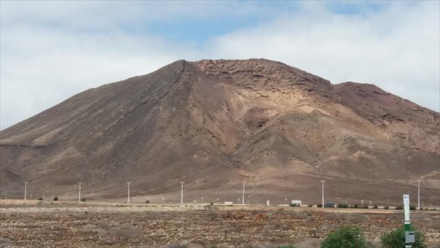
Montaña Roja es un cono volcánico que forma parte de los volcanes de la serie Lanzarote II, un grupo volcánico con una edad estimada de 13 millones de años a 800,000 años.
Un cono volcánico, también llamado cono de ceniza o cono de escoria según los materiales que lo componen, es la estructura de origen volcánico en forma de montaña o colina formada por la pila de tefra durante una sola erupción. (volcán monogénico) o varias erupciones (estratovolcán).
La erupción tiene 800,000 años de antigüedad. La lava fluyó a través de una brecha en el norte del volcán, hasta el océano cuyo nivel era en ese momento unos diez metros más alto
Las formaciones rocosas áridas en los flancos del volcán son el hogar de mechones de baja vegetación característicos de las tierras áridas y perturbadas del sur de Lanzarote. Los arbustos raros (Euphorbia balsamifera, Launaea arborescens) no superan los 50 centímetros de altura.
Un arbusto espinoso con Lycium intricatum y Launaea arborescens ocupa el fondo del cráter. Forma un círculo de unas pocas decenas de metros de diámetro.

Para llegar allí:
La escalada se realiza a una hora de Playa Blanca, un camino al norte del volcán y circundando el cráter, los flancos oeste y sur están sujetos a deslizamientos de tierra.
Pero una vez al pie del volcán, la escalada lleva menos de 30 minutos

Rocailles a lo largo del camino hacia la cumbre.
Para registrar este caché => su MISIÓN:
Probablemente habrás entendido que el objetivo principal es visitar este volcán. desde entonces:
1/ ¿Cómo se clasifica Montaña Roja? Explica con tus palabras basadas en el texto y lo que ves.
2 /Ve a WP1 y mide a través de tu GPS la altitud a la que te encuentras.
3 / Luego, vaya a WP2 y haga la misma operación
4 / Opcional: agregue a su registro fotos de su GPS, fotos del volcán o fotos originales. Deja que tu imaginación hable
Luego envíeme sus respuestas a través de mi buzón de correo o a través del centro de mensajes de geocaching. Luego puede registrar "lo encontró" y me pondré en contacto con usted en caso de respuestas incorrectas.
Sin estas condiciones, estaría obligado a eliminar su registro.

Montaña Roja is a volcano south of the island of Lanzarote in the Canary Islands. Culminating at 194 m altitude, it is located in the town of Yaiza and dominates the resort of Playa Blanca
Montaña Roja is a volcanic cone that is part of the volcanoes of the Lanzarote II series, a volcanic group with an estimated age of 13 million years to 800,000 years.
A volcanic cone, also called ash cone or slag cone depending on the materials that compose it, is the structure of volcanic origin in the form of mountain or hill formed by the stack of tephras during a single eruption. (monogenic volcano) or several eruptions (stratovolcan).
The eruption is 800,000 years old. The lava flowed through a breach on the north of the volcano, to the ocean whose level was at that time about ten meters higher
The arid rock formations on the flanks of the volcano are home to tufts of low vegetation characteristic of the dry and disturbed badlands of southern Lanzarote. The rare shrubs (Euphorbia balsamifera, Launaea arborescens) do not exceed 50 centimeters in height.
A thorny bush with Lycium intricatum and Launaea arborescens occupies the bottom of the crater. It forms a circle of a few tens of meters in diameter.
-
To get there:
The climb is an hour from Playa Blanca, a path on the north of the volcano and circling the crater, the west and south flanks are subject to landslides.
But once at the foot of the volcano, the climb takes less than 30 minutes
Rocailles along the path to the summit.
To log this cache => your MISSION:
-
You will probably have understood the main purpose being to visit this volcano. since then:
1 / How is Montaña Roja classified? Explain with your words based on the text and what you see.
2 / Go to WP1 and measure via your GPS, the altitude at which you are.
3 / Then, go to WP2 and do the same operation
4 / Optional: add to your log either photos of your GPS, photos of the volcano, or original photos. Let your imagination speak
Then send me your answers either via my mailbox or via the geocaching message center. Then you can log "found it" and I will contact you in case of wrong answers.
Without these conditions, I would be obliged to delete your log.
Have a good visit, good research and especially good fun!