Gogleys Lagoon
Gogleys Lagoon can be accessed from a number of points around the shoreline.
Lagoon is derived from the Italian laguna, which refers to the waters around Venice. Laguna has been anglicised to "lagune". Captain James Cook described an island "of Oval form with a Lagoon in the middle" in 1769.
A lagoon is a common coastal feature around many parts of the world.
Most, if not all lagoons do not include the term ‘lagoon’ in their name. One example is Wollongong’s ‘Lake Illawarra’. Lagoons are often called estuaries, sounds, bays, or even lakes, although the terms "lagoon" and "estuary" are often loosely applied. Normally lagoons are elongated and parallel to the coast, while estuaries are usually drowned river valleys, elongated perpendicular to the coast. Lagoons are bodies of water with little or no fresh water inflow, and little or no tidal flow, and any bay that receives a regular flow of fresh water is an "estuary". A lagoon is a shallow, often elongated body of water separated from a larger body of water by shallow or exposed barrier islands or reefs. They have also been identified as occurring on mixed-sand and gravel coastlines. Lagoons are commonly divided into two types, coastal lagoons and atoll lagoons.
Atoll lagoons form as coral reefs grow upwards while the islands that the reefs surround subside, until eventually only the reefs remain above sea level. Unlike the lagoons that form shoreward of fringing reefs, atoll lagoons often contain some deep portions.
Coastal lagoons do not form along steep or rocky coasts, or if the range of tides is more than 4 metres. They form along gently sloping coasts where barrier islands or reefs can develop off-shore, and the sea-level is rising relative to the land along the shore (either because of an intrinsic rise in sea-level, or subsidence of the land along the coast). Due to the gentle slope of the coast, coastal lagoons are shallow; however, they are sensitive to changes in sea level.
The size and depth of coastal lagoons often depend on sea level. A relative drop in sea level may leave a lagoon largely dry, and looking like swampy wetlands. When the sea level rises, they can look like coastal lakes or bays, and may let the sea breach or destroy barrier islands leaving reefs too deep under water to protect the lagoon.
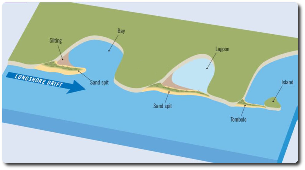
Coastal lagoons are usually connected to the open ocean by inlets between barrier islands. The number and size of the inlets, precipitation, evaporation, and inflow of fresh water all affect the nature of the lagoon. Those with many wide inlets have strong tidal currents and mixing.
Coastal lagoons tend to accumulate sediments from inflowing rivers, from runoff from the shores of the lagoon, and from sediment carried into the lagoon through inlets by the tide. Large quantities of sediment may be occasionally be deposited in a lagoon when storm waves over-wash barrier islands. Mangroves and marsh plants can also facilitate the accumulation of sediment in a lagoon.
Lagoons behind coastal barriers normally are zones of fine sedimentation as conditions are quieter. The lagoonal muds differ from shelf muds. The source of the fine sediment is from inland areas, and transport is by rivers. Their bottom profiles, therefore, build up gradually with time.
Lagoons with little or no interchange with the open ocean, little or no inflow of fresh water, and high evaporation rates may become highly saline. While those with no connection to the open ocean and significant inflow of fresh water, may be entirely fresh.
In hot arid regions lagoons lose more water by evaporation than they receive from land drainage. This causes surface waters to become more dense than seawater and to sink to the bottom. Seawater flows in at the surface to replace that lost by evaporation, creating a circulation the reverse of that found in estuaries. If exchange with the open sea is limited, the lagoon may become much more saline than the open sea.
The temperature and salinity of barrier island lagoons are more variable because of their wider climatic range. Because they are shallow, lagoon waters approximate the air temperature: colder than the open ocean in winter, warmer in summer.
Lagoons can also be man-made and used for wastewater treatment, as is the case for waste stabilization ponds. Examples of human-made lagoons include anaerobic lagoons and aerated lagoons.
Anaerobic Lagoons are man-made outdoor earthen basins created from manure slurry (animal waste) which is washed out from the animal pens and then piped into the lagoon. Aerated Lagoons are wastewater treatment plants.
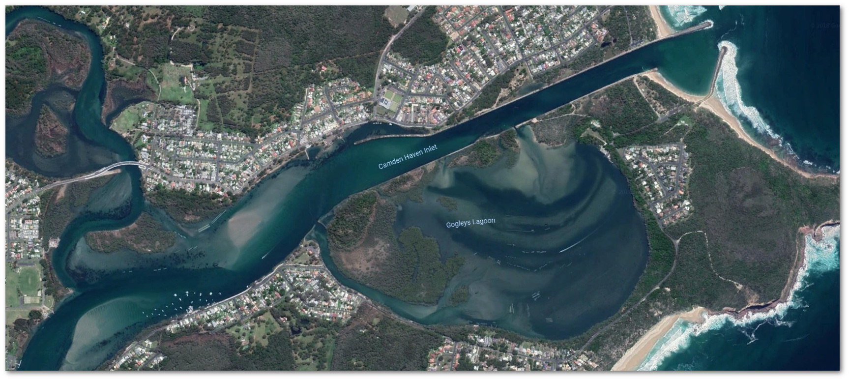
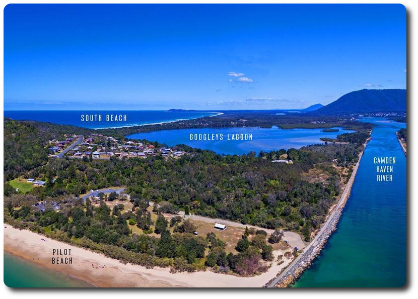
Gogleys Lagoon was formed in 1902 when the construction of the southern training wall isolated a section of the lower reaches of the Camden Haven. Prior to construction of the training wall the main river entrance channel swept around the base of Camden Head, past Dicks Hill and Dunbogan. The main entrance channel to the present Gogleys Lagoon is at the western end of the lagoon between Dunbogan and Gogleys Island. The southern training wall separating Gogleys Lagoon from the entrance channel has been breached during flood events on several occasions. Tidal flow into and out of the lagoon now occurs at the western and eastern entrances and at several points along the training wall. Tidal flow within the lagoon is exchanged in two tidal cycles. Of this flow, the Department of Public Works estimated that 69% entered through the western entrance, 16% through the eastern entrance and 15% through training wall breaches. Analysis of circulation patterns within Gogleys Lagoon has indicated that a nett circulation of 12% occurs, the waters being well mixed during a tidal cycle. During the flood tide approximately 10% of the water entering the lagoon from the western entrance is river water from the preceding ebb tide. Gogleys Lagoon near the mouth of the Camden Haven River is considered to be a geomorphically significant feature. The lagoon contains mangrove, saltmarsh and littoral rainforest communities, and provides important habitat for migratory waders. The close proximity to the subtidal habitats of Perpendicular Headland provide an immediate connection between estuarine and ocean habitats.
Logging Requirements:
Please submit your answers to the questions to me via the above links. Should any clarification be needed I will contact you.
You may log your find immediately, however please be aware that if the logging logging requirements are not met and within 10 days you risk your log being deleted. Thanks.
QUESTIONS:
1. Looking at the above satellite image and observing the lagoon from the parking locations notice the distribution of sands within the lagoon (the sands being the light coloured areas) Why do you think they are distributed in this way?
2. Do you think lagoons change with time? Explain the reason for your answer.
3. At the Dunbogan Reserve observation point '01' or observation point '06', take note of the tidal delta within the lagoon inlet.
a) What do you notice about the tidal delta?
b) What is the cause and effect on this location?
4. Please include a photo showing yourself or your gps at the lagoon.
Sources:
www.nationalgeographic.org/encyclopedia/lagoon
www.britannica.com/science/lagoon-geography
en.wikipedia.org/wiki/Lagoon