
Depositi fluviali primordiali
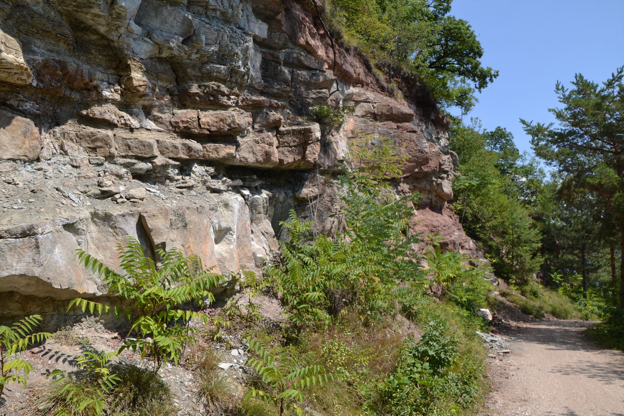
Ci troviamo qui in fronte a un affascinante affioramento gelogico, una sorta di finestra sulla preistoria. Gli strati rossi e grigi di arenarie e peliti della formazione di Val Gardena, con le loro tipiche strutture sedimentarie, le formazione nodulari e i residui vegetali carbonizzati costruiscono antichissime deposizioni fluviali. Nel Permiano, 260 milioni di anni fa, il paesaggio di queste zone era molto diverso da quello odierno. L’area faceva parte del supercontinente Pangea. Le infinite distese di sabbia arrivavano fino all’orizzonte. Le pianure desertiche furono attraversate dai corsi d’acqua scesi dalle alture occidentali e diretti a est verso Mediterraneo primordiale, la Tetide. In base alle fluttuazioni stagionali della portata idrica, questi fiumi depositarono i loro trasporti di sabbia e argilla sul fondo dell’alveo e, con le piene, nelle pianure alluvionali. La struttura ciclica dei sedimenti mostra le formazioni prodotte da un bacino fluviale ramificato e lievemente meandrante. Il colore rossastro delle argille e i noduli di Dolomia grandi quanto un pugno testimoniano chiaramente l’antica esistenza di un clima desertico.
Com'è sembrato prima?
Le Argille e arenarie della formazione di Val Gardena, originate nel Permiano, sono deposizioni fluviali preistoriche. Si formano per effetto del complesso sistema di processi di erosione, sedimento-trasporto e deposizione.
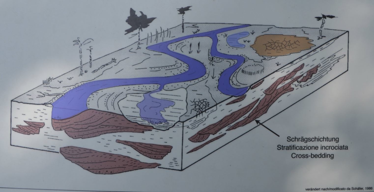
L’immagine mostra un fiume meandrante con le tipiche sedimentazioni di una piana alluvionale, caratterizzata da una scarsa copertura vegetazionale.
Per loggare questa Earthcache, andare in questa posizione e rispondere alle seguenti domande. Quindi pubblica una foto di te nel luogo del tuo log. Ovviamente, se non vuoi apparire nella foto, un oggetto personale nella foto è una prova sufficiente della tua presenza. (Secondo le linee guida di Earthcache, è richiesto il fotoritocco dal giugno 2019.)
1.) Guarda attentamente l'affioramento. Banchi di arenaria più spessi si alternano a strati più sottili di arenaria carbonifera. Quanto è spesso questo strato carbonifero?
2.) Sul terreno davanti al muro troverete alcune rocce dello strato di arenaria carbonifera. Scegline uno e descrivi cosa puoi riconoscere (dettagli, colore, durezza).
3.) In quale epoca si sono formati questi strati di arenaria carbonifera?
Puoi loggare immediatamente. Se qualcosa non è corretto, ti contatterò

Urzeitliche Flussablagerungen
Wir stehen hier vor einem faszinierenden Gesteinsaufschluss, der uns ein Fenster in die Urzeit öffnet. Die roten und grauen Sand- und Tonsteinschichtender Gröden-Formation mit ihren typischen Sedimentstrukturen, den knolligen Bodenbildungen und den verkohlten Pflanzenresten stellen uralte Flussablagerungen dar. In der Permzeit vor 260 Millionen Jahren hat es hier ganz anders ausgesehen als heute. Das Gebiet war ein Teil des Superkontinents Pangäa. Weite Sandebenen dehnten sich bis zum Horizont aus. Die wüstenhaften Ebenen wurden von Flüssen aus den Gebirgen im Westen auf ihrem Weg zum östlich gelegenen Ur-Mittelmeer Tethys durchströmt. Entsprechend der jahreszeitlich schwankenden Wasserführung lagerten die Flüsse ihre sandig-tonige Fracht in den Fließrinnen und bei Hochwasser in den Talauen ab. Die zyklisch aufgebauten Sedimente stellen Bildungen eines verzweigten bis leicht mäandrierenden Flusssystem dar. Die rote Farbe der Tonsteine und ihre faustgroßen Dolomit-Knollen belegen eindeutig ein wüstenhaftes Klima.
Wie sah es früher aus?
Die Ton- und Sandsteine der permischen Gröden-Formation sind vorzeitliche Flussablagerungen. Sie bildeten sich durch ein komplexes System von Erosion, Sediment-Transport und Ablagerung.
Die Abbildung zeigt einen mäandrierenden Fluss mit seinen typischen Sedimenten in einer Schwemmlandebene mit spärlichem Pflanzenbewuchs.
Um diesen Earthcache zu loggen, begib dich zu dieser Location und beantworte nachfolgende Fragen. Anschließend postet zu eurem Log bitte noch ein Foto von euch an der Location. Wenn ihr selbst nicht auf dem Foto erscheinen wollt, reicht natürlich auch ein persönlicher Gegenstand auf dem Foto als Beweis eurer Anwesenheit. (Laut Earthcache Guidelines ist die Forderung eines Fotobeweises seit Juni 2019 wieder erlaubt.)
1.) Betrachtet nun den Aufschluss. Dicke Sandsteinbänke wechseln mit dünnen kohleführenden Sandsteinlagen. Wie dick sind diese kohleführenden Schichten?
2.) Am Boden vor der Wand findest du einige Gesteine aus der kohleführenden Sandsteinlage. Suche dir einen aus und beschreibe was du erkennen kannst ( Einzelheiten, Farbe, Härte ).
3.) In welchem Zeitalter haben sich diese kohleführenden Sandsteinlagen gebildet?
Danach könnt Ihr sofort loggen. Wenn irgendetwas nicht in Ordnung sein sollte, melde ich mich.

Primeval alluvial deposits
We are standing in front of a fascinating outcropping which opens a window for us into the distant past. The red and gray layers of the Gardena Formation and their typical sendimentary structures, the nodular formations, and the carbonized plant material represent ancient alluvial deposits. During the Permian Period, 260 million years ago, this place had a very different appearance than today. This area was a part of the supercontinent called Pangea. The land here was covered with plains of sand stretching to the horizon. These desolate plains were crossed by rivers flowing from the mountains to the proto-Mediterranean Sea in the west called Tethys. Depending upon the annual fluctuations in the flow of water, the rivers deposited varying amounts of sandy and clayey material in the river beds and – during flooding – in the flood plains. The sediments were laid down in cycles, forming a branching and slightly meandering river system. The red color of the shales and the fist-sized nodules of dolomite embedded in them are evidence of a desert climate.
What did it look like earlier?
The shales and sandstones of the Permian Gardena Formation are prehistoric alluvial deposits. They were formed by a complex system of erosion, the transport of sediment, and deposits.
The illustration depicts a meanddering river with its typical sediments in an alluvial plain with sparse vegetation.
To log this Earthcache, go to this location and answer the following questions. Then post a photo of you at the location to your log. Of course, if you do not want to appear in the photo, a personal item in the photo is enough proof of your presence. (According to the Earthcache Guidelines, photo-proofing has been required since June 2019.)
1) Look closely at the outcrob. Thicker sandstone Banks alternate with thin coal-bearing strata of sandstone. How thick are These coal-bearing strata?
2) On the ground in front of the wall you will find some rocks from the carboniferous sandstone layer. Choose one and describe what you can recognize (details, color, hardness).
3) In which age did these carboniferous sandstone layers form?
After that you can give your log directly. If anything is not ok, i will contact you.
l'indice delle fonti:
· Sentiero geologico Valle dell’Inferno
· Wikipedia
· Grafik: Schäfer, 1986
· Geoweg Höllental
· Fotos intrinsecamente