


|
HISTORIA OBALONEGO DRZEWA
|
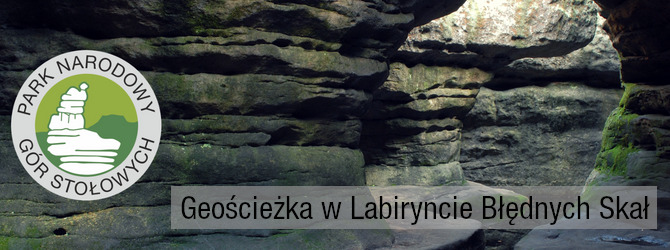
Góry Stołowe - kraina zrodzona z morza miliony lat temu… to jedno z najpiękniejszych i najatrakcyjniejszych pasm górskich w Polsce, miejsce wyjątkowe ze względu na swoje ukształtowanie terenu, przepiękne formacje skalne, unikalne skalne miasta, labirynty oraz osobliwe formy zwane skalnymi grzybami. Wybitne walory przyrodnicze i krajobrazowe sprawiły, że od 1993 roku ustanowiono tu Park Narodowy Gór Stołowych.
Labirynt Błędnych Skał znajduje się na północno-zachodniej krawędzi Skalniaka. Obejmuje on swoim zasięgiem zespół osobliwych form skalnych o wysokości 6 - 11 m, wytworzonymi wskutek wietrzenia piaskowca. Błędne Skały to labirynt szczelin i zaułków, niekiedy niezwykle wąskich, oddzielających bloki skalne kilkunastometrowej wysokości. Wiele skał ma własne nazwy np.: "Skalne Siodło", "Kurza Stopka", "Labirynt", "Tunel", "Wielka Sala". Jedyny taras widokowy na trasie to Skalne Czasze. Widoczny stąd jest m.in. Szczeliniec Wielki i Mały, miejscowość Machov, a przy dobrej widoczności zobaczyć możemy także Karkonosze! Trudne warunki, które zazwyczaj tu panują powodują, że większość świerków ma połamane korony, a pozostałe gatunki drzew, takie jak sosna i brzoza przyjmują fantazyjnie powyginane kształty. To miejsce unikalne – zwiedzaj, ciesz się górami, zbieraj kesze; ale nie niszcz, nie śmieć - zachowajmy to piękno dla następnych pokoleń.
|

|
|
W przeszłości niemal cała powierzchnia wierzchowiny Skalniaka była pokryta zespołem torfowisk, z których ostało się tylko Długie i Krągłe Mokradło. Wszystko za sprawą melioracji, którą przeprowadzono w XIX w., aby miejscowe warunki wodne bardziej sprzyjały hodowli lasu. Wierzchowina Skalniaka została pocięta dziesiątkami kilometrów rowów odwadniających, które stopniowo osuszały teren. Coraz mniejsza dostępność wody prowadziła do murszenia torfu i zaniku roślinności wilgociolubnej. Na jej miejsce wprowadzono charakterystyczną dla całych Sudetów monokulturę świerka pospolitego. Niestety świerk był obcego pochodzenia. W związku z tym nie posiadał cech, które pozwoliłyby mu przetrwać w obcych warunkach. Dlatego przy obniżeniu wód gruntowych doszło do osłabienia drzewostanów. W związku z obniżeniem kondycji drzew jeden z największych wrogów polskich drzewostanów kornik drukarz zebrał tutaj swoje żniwo.
|
|
Martwe drzewa częściowo zostały usunięte z powierzchni, jednak część żywych i martwych drzew pozostała. Faktem, który możemy dostrzec, że świerk nie jest tutaj gatunkiem występującym naturalnie są powalone drzewa. Świerk jako jeden z nielicznych posiada talerzowy system korzeniowy. Podziwiając obalone drzewo nie znajdziemy w karpie głównego korzenia, który podrzymuje drzewo i częściowo zabezpiecza je przed obaleniem. Obraz lasu po którym przechodzicie jest najlepszym dowodem na to, że nie należy regulować przyrody.
|
|

|
O keszu: Kesz znajduje się przy szlaku trasy turystycznej! NIE ma możliwości dotarcia do kesza w sposób inny niż ścieżką turystyczną.
Działaj rozważnie, by przy podejmowaniu nie narażać się na niebezpieczeństwo - NIE ma konieczności wchodzenia na skały ani wspinania się na cokolwiek! Bacz na przechodniów aby nie "spalić" lokalizacji kesza. Na zakończenie odłóż go, proszę, dokładnie w to samo miejsce. „Niewidzialność” na najwyższym poziomie!
Na obszarze Parku Narodowego ochronie podlega całość przyrody, swoiste cechy krajobrazu oraz obiekty dziedzictwa narodowego. Zadaniem Parku Narodowego jest nie tylko ochrona tego szczególnego krajobrazu, ale również udostępnianie go dla zwiedzających. Pamiętaj jednak o pewnych zasadach:
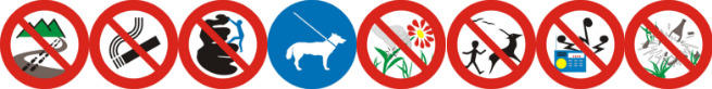
- Poruszanie się szlakiem turystycznym jest najbezpieczniejsze dla Ciebie i dla przyrody… nie wychodź poza szlak. Ze szlaku są najpiękniejsze widoki.
- Nabierz w płuca świeżego, górskiego powietrza, nie pal papierosów.
- Skały wokół Ciebie nie są dobrym materiałem do wspinania, odpuść sobie wchodzenie na nie. Tam nie ma keszy.
- Kamienie i minerały leżą tu miliony lat… zostaw je dla następnych pokoleń. Nie zbieraj i nie wydobywaj skał i minerałów.
- Jeśli keszujesz razem z psem, twój przyjaciel będzie bezpieczniejszy na smyczy.
|
|
- Przyroda żyje w symbiozie - nie niszcz i nie zbieraj roślin, owoców ani runa leśnego.
- Zwierzęta żyją tu na wolności, to ich dom. Uszanuj ich spokój, nie płosz, nie chwytaj, nie dokarmiaj zwierząt.
- Ciesz się ciszą i odgłosami natury - zachowuj się cicho, nie krzycz, nie śpiewaj, nie używaj odbiorników radiowych. Pozwól innym radować się naszymi górami, nie zakłócaj spokoju pozostałych osób.
- Co przyniosłeś – zabierz ze sobą. Śmieci zabieraj ze sobą i pozostaw w wyznaczonych miejscach przy schronisku lub wejściach na szlak.
|

|
STORY OF A FALLEN TREE
|
Góry Stołowe (the Table Mountains) - a land born of the sea, millions of years ago... is one of the most beautiful and attractive mountain ranges in Poland, a unique place due to its terrain, beautiful rock formations, unique “rock cities”, labyrinths and peculiar forms called rock fungi. Outstanding natural and landscape values are reasons that the National Park of the Table Mountains has been established here in 1993.
Labirynt Błędnych Skał - The Maze of Errant Rocks is located on the north-western edge of Skalniak. It covers a complex of peculiar rock formations with a height of 6 - 11 m, created as a result of weathering sandstone. Errant Rocks is a maze of crevices and alleys, sometimes extremely narrow, separating rock blocks of several meters in height. Many rocks have their own names, for example: “ The Rock Saddle”, “The Hen’s Leg”, “The Tunnel” and “The Grand Hall”. The only observation deck on the route is “The Rock Skuls”. The Szczeliniec Wielki and Mały, city of Machov, and in good visibility, The Karkonosze mountains can be seen from here. Difficult weather conditions, which usually prevail here, cause that the majority of spruces have broken crowns, and other tree species, such as pine and birch, take fanciful, bent shapes. This is a unique place - visit, enjoy the mountains, collect caches; but do not destroy, do not litter - let's preserve this beauty for the next generations.
|

|
|
In the past, almost the entire surface of Skalniak's top was covered with a set of peat bogs, of which only The Long and Round Bog (Długie i Kragłe Mokradło) were left. All thanks to the drainage that was carried out in the 19th century, so that the local water conditions would be more favorable to forest cultivation. The Skalniak top has been cut with dozens of kilometers of drainage ditches, which gradually drained the area. The lower availability of water led to peat moss drying and the disappearance of wetland vegetation. In its place, the monoculture of Norway spruce, so-called artificial Sudeten spruce forest, was introduced in the entire Sudetenland.
|
|
Unfortunately, the spruce was of foreign origin. Therefore, it did not have features that would allow survival in foreign conditions. With the lowering of groundwater, trees were weakened. The weakened trees became a tasty morsel for the bark beetle. Dead trees were partially removed from the area, but the greater part of the living and dead trees remained. The fallen trees we can see are evidence that spruce is not a naturally occurring species in the area. The spruce is one of the few species of trees that has a disk root system. When you look at the fallen tree, you will not find the main root in the carps, which could keep the tree up and protect it from falling. The image of the forest you witness here is the best proof that nature should not be regulated.
|
|
|
About the cache: The cache is hidden along the tourist trail! It is NOT possible to reach this cache from a different direction but from the trail.
Act carefully so that you take no risks. You do not have to go on rocks or climb anything! Take care of passers-by so as not to disclose the cache location to Mugglers. Finally, put it back, in exactly the same place, please. "Invisibility" at the highest level!
The all of nature, specific landscape features and national heritage objects are protected in the area of the National Park. The task of the National Park is not only to protect this particular landscape, but also to make it available for visitors. However, you neet to remember about certain rules:
- Walking on the tourist trail is the safest for you and for nature... do not go beyond the trail. The trail has the most beautiful views. Do not take shortcuts.
- Inhale the fresh mountain air, do not smoke.
- The rocks around you are not good climbing material, let go of them. There is no cache there.
- Stones and minerals lie here for millions of years ... leave them for the next generations. Do not collect and mine rocks and minerals.
- If you're are here with your dog, your friend will be safer on a leash.
|
|
- Nature lives in symbiosis - do not destroy and do not collect plants, fruit or undergrowth.
- Animals live here in the wild, it's their home. Respect their calmness, do not frigten them, do not seize the animals, do not feed them.
- Enjoy the silence and the sounds of the nature - keep quiet, do not shout, do not sing, do not use radio receivers, do not play music. Let others enjoy the mountains, do not disturb the rest of the people.
- Whatever you brought – take it with you. Take away rubbish with you and leave in designated places near the shelter or entrances to the trail.
|
|
HISTORIE PŘEVRÁCENÉHO STROMU
|
Stolowe Hory - země, která se narodila z moře před miliony let ... je jedním z nejkrásnějších a nejatraktivnějších pohoří v Polsku, jedinečné místo díky terénu, nádherné skalní útvary, unikátní skalní města, labyrinty a zvláštní formy nazvané Skalni Houby. Vynikající přírodní a krajinné hodnoty způsobily, že od roku 1993 zde vznikl Národní Park Stolovych Hor.
Bludné skály je přesně chráněné území, které se má rozlohu 22 hektarů. Zde se nacházejí zvláštní skalní skupiny, které dosahují výšky 6-11m a vznikly v důsledku zvětrávání kvádrového pískovce. Bludné skály je labyrint rozevřených štěrbin a slepých uliček, někdy neobyčejně úzkých, oddělujících skalní bloky o několika metrové výšce. Většina skal má vlastní názvy např. "Skalní sedlo", "Kuřecí patka" , "Bludiště", "Tunel", "Velký sál". Na území Bludných skal nachází se vyhlídka, na platformě, která se jmenuje "Skalní lebky". Je odtud viditelná Malá a Velká Hejšovina, Broumovská vrchovina, obec Machov, a když je dobrá viditelnost můžeme obdivovat Krkonoše. Obtížné podmínky, které zde obvykle převládají, způsobují, že většina smreků má zlomené koruny a jiné druhy stromů, jako je borovice a bříza, mají fantazijní, ohnuté tvary. Jedná se o jedinečné místo - návštěvujte, užívájte hory, sběrajte cache; ale nezničte, nehazujte odpadky - zachovejte tuto krásu pro příští generace.
|

|
|
V minulosti byla téměř celý povrch vrcholu Boru pokrytá sadou rašelinišť. Nyní zůstalo pouze Dlouhé a Kulaté rašelinište (Długie a Krągłe Mokradło). Všechno, protože v 19. století vrchol Boru byl řezen desítkami drenážních příkopů, které oblast postupně vypouštěly. Nižší dostupnost vody vedla k sušení rašeliníku a zmizení mokřadní vegetace. Na jejich místě byla zavedena monokultura smrku, tak zvaného umělého sudetského smřekového lesa. Bohužel byl to smrk cizího původu. Proto neměl funkci, která by umožnila přežít v cizích podmínkách. Při spouštění podzemních vod byly stromy oslabeny. Oslabené stromy se staly chutným místem pro kůrovce.
|
|
Mrtvé stromy byly částečně odstraněny z oblasti. Padlé stromy jsou důkazem, že smrk není v oblasti přírodní. Smrk je jedním z mála druhů stromů, které mají plochý kořenový systém. Když se podíváte na padlý strom, nenajdete hlavní kořen, který by mohl udržet strom a chránit ho před pádem. Obraz lesa, který vidíte, je nejlepším důkazem toho, že příroda by neměla být regulována.
|
|

|
O kešce: Keš se nachází vedle turistické stezky. Tuto keš NENÍ možné dosáhnout jiným způsobem než turistická trasa.
Buďte opatrní, abyste pri odlovu nemuseli vylézt na kameny nebo lézt na cokoliv! Počínajte si nenápadně, abychom nebudili zbytečnou pozornost. Dávejte pozor na to, aby se keš vyhýbala zmudlování. Nakonec prosim, vracejte schranku a maskování na puvodni misto. Při odlovu je nutná maximalni opatrnost!
V oblasti Národního Parku celá příroda, specifické krajinné prvky a objekty národního dědictví jsou chráněny. Úkolem Národního parku je nejen chránit tuto krajinu, ale také ji zpřístupnit návštěvníkům. Nezapomeňte však na některé pravidla:
- Cestování po turistické stezce je nejbezpečnější pro vás a pro přírodu ... Nenechávejte označenou stezku. Z turisticke cesty jsou nejkrásnější pohledy.
- Dejte si čerstvý horský vzduch, nekuřte.
- Skály kolem vás nejsou dobrým místem k lezení, nechodíte na ně. Není zde žádná keška
- Kameny a minerály leží zde milióny let ... nechávají je pro příští generace. Nesbírejte skály a minerály.
- Pokud jdete se svým psem, váš přítel bude bezpečnější na vodítku.
|
|
- Příroda žije v symbióze - nezničte a nesbírajte rostliny, ovoce ani podrost.
- Zvířata žijí tady ve volné přírodě, je to jejich domov. Respektujte jejich klid, nebojte se, nezachycujte zvířata a ne krmte.
- Užijte si ticho a zvuky přírody - udržujte klid, neříkejte, nepějte, nepoužívejte rádiové přijímače. Nechte ostatní užívat naše hory, nerušíte klid ostatních turistů.
- Co jste přinesli - vezměte si s sebou. Odveďte s sebou odpadky a nechte na určených místech v blízkosti turisticke chaty nebo vjezdu do stezky.
|
|
DIE GESCHICHTE EINES UMGESTÜRZTEN BAUMES
|
Die Góry Stołowe (= „Tafelberge”, dt. Heuscheuergebirge) – vor Millionen von Jahren vom Meer geformt, gehören sie zu den schönsten und attraktivsten Gebirgszügen Polens. Sie besitzen eine Vielzahl einzigartiger Felsformationen, Felsenstädte, Labyrinthe und Pilzfelsen. Kein Wunder also, dass sie seit 1993 als Nationalpark (poln. Park Narodowy Gór Stołowych) unter besonderem Schutz stehen.
Das Maze of Errant Rocks (Wilde Löcher) befindet sich am nordwestlichen Rand von Skalniak. Es umfasst das Angebot Band eigentümlichen Felsformationen mit einer Höhe von 6 bis 11 m, die durch Sandstein Verwitterung. Errant Rocks ist ein Labyrinth von Spalten und Gassen, manchmal extrem eng, die Felsblöcke von mehreren Metern Höhe trennen. Viele Felsen haben ihre eigenen Namen, zum Beispiel: “Rocksattel”, “Tunnel” und ” Große Halle”. Die einzige Aussichtsplattform auf der Route ist ” Rock Bowls.” Es ist von hier aus sichtbar Großeund Kleine Heuscheuer , Machov, und bei guter Sicht können wir auch das Riesengebirge sehen! Schwierige Bedingungen, die hier vorherrschen, führen dazu, dass die meisten Fichten gebrochene Kronen haben und andere Baumarten wie Kiefer und Birke phantasievolle, gebogene Formen annehmen. Besucht diesen einzigartigen Ort, freut Euch an den Bergen, sammelt dabei ein paar Caches; hinterlasst aber bitte nichts zerstört oder vermüllt – bewahren wir das Schöne für kommende Generationen.
|

|
|
In der Vergangenheit war fast die ganze Fläche des Berges Skalniak mit Torfmoorkomplex bedeckt. Davon sind nur Długie und Krągłe Mokradło erhalten geblieben. In der 19. Jahrhundert wurde die Melioration durchgeführt, damit die örtlichen Wasserbedingungen die Waldzucht begünstigen konnten. Es gab dort viele Kilometer Entwässerungsgräben, die das Gebiet schrittweise trockneten. Die immer knapper werdenden Wassermengen führten zur Torffäulnis und wasserbedürftige Pflanzen verschwanden. Die für die Sudeten charakteristische Monokultur der Fichte ( picea abies) wurde an diese Stelle eingeführt. Die Fichte war leider fremder Herkunft. Deshalb fehlten ihr Eigenschaften, die dieser Art erleichtern können, in anderen Bedingungen zu gedeihen.
|
|
Die Grundwasserabsenkung hat Abschwächung des Baumbestandes zur Folge. Die geschwächte Kondition der Bäume war die Ursache für die Plagge von Holzkäfern. Tote Bäume wurden zum Teil vom Boden weggenommen, aber manche gesunde und tote Bäume liegen immer noch. Die liegenden Bäume sind ein Beweis dafür, dass diese Art auf diesem Gebiet nicht in ihrer natürlichen Umgebung wächst. Die Fichte, als eine Art, besitzt ein tellerförmiges Wurzelsystem. Es ist kaum möglich, an einem gefällten Baum, einen Hauptwurzel zu finden, der ihn vor dem Absturz schützt. Der Wald, in dem ihr seid, ist der beste Beweis dafür, dass man die Natur nicht regulieren soll.
|
|

|
Der Cache liegt an der touristischen Route! Es ist NICHT möglich, diesen Cache anders als den Touristenpfad zu erreichen.
Handelt verantwortlich und begebt Euch nicht in Gefahr – es besteht KEIN Anlass, auf Felsen oder sonstiges zu klettern! Achtet bitte darauf, das Versteck nicht zu verraten und legt den Cache bitte genau wieder so zurück, wie Ihr ihn gefunden habt. „Stealth Mode“ wird vorausgesetzt!
Auf dem Gebiet des Nationalparks sind Natur, Landschaft und Objekte nationalen Erbes in ihrer Gesamtheit geschützt. Zu den Aufgaben des Nationalparks gehört dem Schutz der Landschaft auch deren Bereitstellung für Besucher. Beachtet dabei bitte einige Regeln:
- Das Wandern auf markierten Wegen ist am besten für Euch und die Natur... verlasst sie deshalb nicht. Vom Weg aus hat man die schönsten Ausblicke.
- Atmet die frische Bergluft ein, raucht nicht.
- Die Felsen ringsum sind kein geeigneter Platz zum Klettern. Verzichtet also darauf, Caches findet Ihr dort keine.
- Steine und Mineralien liegen hier seit Jahrmillionen... nehmt sie bitte nicht mit, sondern lasst sie für die kommenden Generationen liegen.
- Cachen mit Hund? Klar, aber am besten an der Leine.
|
|
- Die Natur lebt in Symbiose – zerstört / pflückt keine Pflanzen, Früchte oder Bodendecker.
- Die Tiere leben hier in Freiheit, in ihrem Zuhause. Lasst ihnen Ihre Ruhe, scheucht sie nicht auf, fangt und füttert sie nicht.
- Genießt die Ruhe und die Stimmen der Natur – verhaltet Euch ruhig, schreit oder singt nicht und benutzt keine Radios oder ähnliches. Respektiert auch die Ruhe der anderen Besucher.
- Nehmt mit, was Ihr mitgebracht habt. Werft Euren Müll in die dafür vorgesehenen Behälter an der Schutzhütte oder am Beginn des Wanderwegs.
|