
Monte Calvario
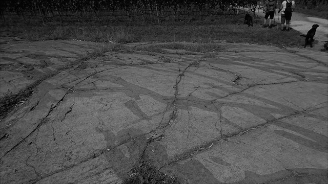
La base geologica é formata dal porfido quarzifero bolzanino che si eleva fino alle terrazze di media montagna di Gaido-Prendonico-Matschatsch. Al di sopra si estende l’arenaria della Val Gardena, seguita dagli strati di Werfen sabbiosi-marnosi. Qui si inseriscono enormi banchi di dolomia dello Sciliar e della Mendola che sono anche alla base delle fughe di parete della cresta della Mendola. Il territorio centrale di Appiano è costituito dalle terrazze oltra tesine che si estendono fra i 400-500 m su vaste superfici pianeggianti e che dalla zona di Monte si inseriscono fluidamente nel pendio della Mendola. Si tratta di enormi distese di pietrisco dell’interglaciale Riss-Würm che hanno riempito la Val d’Adige che un tempo scorreva qui; in parte si rileva anche Löss. Pochi passi dietro la cappella del Monte Calvario si trova una roccia levigata da un ghiacciaio.  È considerata una delle più belle dell’Alto Adige; essa lascia ben riconoscere l’effetto erosivo e ai lati è ancora delimitata da materiale morenico (nel vigneto adiacente). Questa roccia, dalle notevoli misure di 75 m di lunghezza e 6-23 m di larghezza con una superficie totale di circa 1.100 m quadrati, si formò a seguito della detersione del ghiacciaio dell’Adige avvenuta per mezzo della levigatura effettuata dal pietrame. Il porfido quarzifero è normalmente una roccia molto dura, che tuttavia in alcuni punti può risultare assai fragile. Nel ghiaccio del ghiacciaio trasportato materiale roccioso diverse dimensioni di grano - da argilla fine a più metri misurano macigni - possono lasciare tracce significative nel fondo della roccia. Il materiale a grana fine di solito ha una macinatura con l'effetto della carta vetrata. La cosidetta detersione agisce prevalentemente sul lato sopravvento, affrontando il movimento del ghiaccio su elevazioni del terreno. Laddove il porfido compatto presenta delle fessure, nel corso del tempo sono avvenute reazioni chimiche. In seguito a ciò nella roccia sono sorte zone di ossidazione che oggi sono riconoscibili come strisce di colore scuro. span>
Per loggare questa Earthcache, andare in questa posizione e rispondere alle seguenti domande. Quindi pubblica una foto di te nel luogo del tuo log. Ovviamente, se non vuoi apparire nella foto, un oggetto personale nella foto è una prova sufficiente della tua presenza. (Secondo le linee guida di Earthcache, è richiesto il fotoritocco dal giugno 2019.)
1.) Cosa pensi da dove vengono le crepe, dove ora vediamo le zone di ossidazione?
2.) Descrivere le zone di ossidazione e confrontarle con il porfido di quarzo rimanente (più luminoso) (dettagli, colore, durezza). Utilizzare un coltello (o qualcosa di simile) per il test di durezza.
3.) Come saranno le zone di ossidazione in futuro? ? Si stanno allargando o rimanendo in questa misura?
Puoi loggare immediatamente. Se qualcosa non è corretto, ti contatterò

Gleifhügel
Die geologische Basis besteht aus dem Bozner Quarzporphyr, der sich bis zu den mittleren Bergterrassen von Gaido-Prendonico-Matschatsch erhebt. Oben ist der Grödner Sandstein, gefolgt von den sandigen Mergelschichten von Werfen. Hier sind riesige Dolomitbänke des Schlern und Mendel, die auch an der Basis der Bergflanken des Mendel-Bergrückens sind. Das zentrale Gebiet von Eppan besteht aus Terrassen, die sich zwischen 400-500 m auf großen ebenen Flächen erstrecken und sich vom Berg-Gebiet sanft an den Mendel-Hang anschmiegen. Dies sind riesige Stücke von Schotter der Riss-Würm-Eiszeit, die einst in das Etschtal glitten und es füllten; teilweise wird auch Lössboden gefunden. Ein paar Schritte hinter der Kapelle des Monte Kalvarienberg ist ein Fels, der von einem Gletscher poliert wurde. 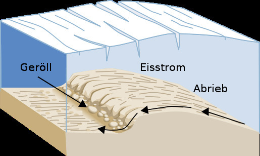 Es ist mit Sicherheit einer der schönsten in Südtirol. Es ermöglicht, dass der erosive Effekt gut erkannt wird und ist an den Seiten immer noch von Moränenmaterial begrenzt (im angrenzenden Weinberg). Dieser Felsen mit den bemerkenswerten Ausmaßen von 75 m Länge und 6-23 m Breite mit einem Gesamtfläche von etwa 1.100 Quadratmetern, ist eine Folge des Etschtal-Gletschers, entstanden durch die Schleifenwirkung, die auf den Fels ausgeübt wurde. Meist zeigt sich der Quarzporphyr von seiner harten Seite, kann stellenweise aber auch sehr brüchig sein. Im Gletschereis mitgeführtes Gesteinsmaterial verschiedenster Korngrößen – von feinem Ton bis zu mehrere Meter messenden Findlingen – kann im Gesteinsuntergrund deutliche Spuren hinterlassen. Feinkörniges Material bewirkt dabei in der Regel einen Schliff vergleichbar mit der Wirkung von Schleifpapier. Die sogenannte Detersion wirkt vorwiegend auf der der Eisbewegung zugewandten Luv-Seite an Erhebungen des Untergrundes. Wo der kompakte Porphyr einige Risse hat, sind im Laufe der Zeit chemische Reaktionen aufgetreten. Danach sind im Fels Oxidationszonen entstanden, die heute als dunkle Streifen erkennbar sind.
Um diesen Earthcache zu loggen, begib dich zu dieser Location und beantworte nachfolgende Fragen. Anschließend postet zu eurem Log bitte noch ein Foto von euch an der Location. Wenn ihr selbst nicht auf dem Foto erscheinen wollt, reicht natürlich auch ein persönlicher Gegenstand auf dem Foto als Beweis eurer Anwesenheit. (Laut Earthcache Guidelines ist die Forderung eines Fotobeweises seit Juni 2019 wieder erlaubt.)
1.) Was denkst du woher die Risse stammen, wo wir nun die Oxidationszonen sehen?
2.) Beschreibe die Oxidationszonen und vergleiche sie mit dem übrigen (helleren) Quarzporphyr ( Einzelheiten, Farbe, Härte ). Benutze für den Test der Härte ein Messer, oder etwas ähnliches.
3.) Wie werden die Oxidationszonen in Zukunft aussehen. ? Werden sie breiter, oder bleiben sie in dieser Ausdehnung?
Danach könnt Ihr sofort loggen. Wenn irgendetwas nicht in Ordnung sein sollte, melde ich mich.

Mont Gleif
The geological base consists of the Bozner quartz porphyry, which rises up to the middle mountain terraces of Gaido-Prendonico-Matschatsch. Above is the Val Gardena sandstone, followed by the sandy marl layers of Werfen. Here are huge Dolomite banks of the Schlern and Mendel, which are also at the base of the mountain flanks of the Mendel ridge. The central area of Eppan consists of terraces that extend between 400-500 m on large flat surfaces and gently nestle from the mountain area to the Mendel slope. These are huge pieces of gravel from the Rift-Würm glaciation that once slid into the Adige Valley and filled it; sometimes loess soil is also found. A few steps behind the chapel of Monte Calvary is a rock that has been polished by a glacier.  It is certainly one of the most beautiful in South Tyrol. It allows the erosive effect to be well recognized and is still limited on the sides by moraine material (in the adjacent vineyard). This rock, which measures 75 m in length and 6-23 m in width and covers a total area of about 1,100 square meters, is a result of the Adige glacier, created by the effect of the sand on the rock. Most of the quartz porphyry shows its hard side, but in places it can also be very brittle. In the glacier ice carried rock material of different grain sizes - from fine clay up to several meters of boulders - can leave significant traces in the rock underground. Fine-grained material usually causes a grinding comparable to the effect of sandpaper. The so-called Detersion acts predominantly on the windward side facing the ice movement on elevations of the ground. Where the compact porphyry has some cracks, chemical reactions have occurred over time. Thereafter, oxidation zones were created in the rock, which are now recognizable as dark stripes.
To log this Earthcache, go to this location and answer the following questions. Then post a photo of you at the location to your log. Of course, if you do not want to appear in the photo, a personal item in the photo is enough proof of your presence. (According to the Earthcache Guidelines, photo-proofing has been required since June 2019.)
1) What do you think where the cracks come from, where we now see the oxidation zones?
2) Describe the oxidation zones and compare them with the remaining (brighter) quartz porphyry (details, color, hardness). Use a knife (or something similar) for the hardness test.
3) What will the oxidation zones look like in the future? Are they broadening or staying at this extent?
After that you can give your log directly. If anything is not ok, i will contact you.
l'indice delle fonti:
· Sentiero geologico Valle dell’Inferno
· Wikipedia
· Grafik: Wikipedia,Luis María Benítez
· Fotos intrinsecamente