Francais / English
Les dunes se forment dans des zones où le sable est abondant et non fixé par la végétation (désert, plage, lit fluvial à l'étiage). Le sable est érodé et pris en charge par le vent. Il est transporté au ras du sol, puis s'accumule quand la compétence du vent chute (versant sous le vent). Une dune peut se déplacer par érosion du versant au vent et accumulation sur le versant opposé.
Les dunes littorales ou dunes bordières se forment sur le long des côtes basses où les vents et l'apport de sédiments par la dérive littorale permettent l'accumulation de sable sur les plages. À marée basse, le haut de plage est asséché par le vent ce qui permet le transfert des sables vers l'intérieur des terres, essentiellement par roulage et saltation (processus de transport de sédiment par l'eau ou par le vent. Entrainées par le fluide, les particules de sable se déplacent par sauts. La largeur de l'estran est donc un facteur primordial du bon développement des dunes: plus il est large, plus la surface de déflation éolienne et donc la quantité de sédiments soufflés sont importantes. Dans le processus de formation des dunes, les plantes pionnières jouent un rôle fondamental, assurant le dépôt, la fixation et la stabilisation de l'accumulation dunaire. Ces plantes sont adaptées à l'instabilité du substrat et présentent de longues racines traçantes. La dune littorale est donc une forme d'accumulation sédimentaire fixée par une végétation, il s'agit d'une construction bio géomorphologique. Les dunes littorales, poussées par les vents, peuvent envahir graduellement les terres si la topographie de l'arrière-côte le permet; ce fut l'une des raisons de leur fixation le long de la côte landaise par la plantation d'une forêt de pin maritime. Lors des tempêtes, les dunes constituent une réserve de sable face à l'érosion des vagues: l'attaque directe des vagues entaille la dune et le sable prélevé est transféré dans les petits fonds. Il remonte normalement lors des périodes de calme sous l'action des houles.
Aux coordonnées de la cache, vous trouverez un panneau explicatif de la formation des dunes sur le littoral.
Vous pourrez ensuite marcher en direction du point d'observation de la dune. C'est un excellent endroit pour admirer les surfeurs ou le couché de soleil.
Pour valider cette earth cache vous devrez répondre aux questions suivantes :
WayPoint 1
1- Nommez les différents profils de dune, visibles sur le schéma du panneau explicatif
2- Quels sont les deux phases du cycle naturel de la dune ?
3- A quoi servent les clotures qui bordent la dune ?
WayPoint 2
4- Grâce aux informations recueillies sur le WayPoint1, determinez le profil actuel de la dune.
5- N'hésitez pas à poster une belle photo du lieu sans qu'elle ne permette de répondre aux questions. (facultatif)
Loguez cette cache "Found it" et envoyez-moi vos propositions de réponses soit via mon profil, soit via la messagerie geocaching.com (Message Center), et je vous contacterai en cas de problème
Cette cache a été posé en l'honneur d'une Géocacheuse adorant les EC "DreyXJ6"
-------------------------------------------------------------------------------
***************************************************
-------------------------------------------------------------------------------
The dunes are formed in areas where the sand is abundant and not fixed by vegetation (desert, beach, river bed at low water). The sand is eroded and supported by the wind. It is transported flush with the ground, then accumulates when the skill of the wind drops (downwind). A dune can move by erosion from the slope to the wind and accumulation on the opposite side.
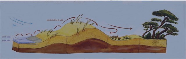
Coastal dunes or bordering dunes are formed along the lower coasts where winds and sediment supply by coastal drift allow the accumulation of sand on the beaches. At low tide, the top of the beach is dried by the wind which allows the transfer of the sands inland, mainly by rolling and saltation (process of sediment transport by water or by wind. sand, the particles of sand move in jumps, the width of the foreshore is therefore a key factor for the good development of the dunes: the wider it is, the more the wind deflation area and therefore the quantity of blown sediments are important. the process of dune formation, the pioneer plants play a fundamental role, ensuring the deposition, fixation and stabilization of the dune accumulation.These plants are adapted to the instability of the substrate and have long tracing roots. is therefore a form of sedimentary accumulation fixed by vegetation, it is a bio geomorphological construction.The coastal dunes, driven by the winds, can Gradually take over land if the topography of the backcountry allows it this was one of the reasons for their attachment along the Landes coast by the plantation of a maritime pine forest. During storms, the dunes constitute a sand reserve against the erosion of the waves: the direct attack of the waves cuts the dune and the sand taken is transferred in the shallows. It goes up normally during periods of calm under the action of the swells.
At the coordinates of the cache, you will find an explanatory panel of the formation of dunes on the coast.
You can then walk towards the observation point of the dune. It is a great place to admire surfers or the sunset.
To validate this earth cache you will have to answer the following questions:
WayPoint 1
1- Name the different dune profiles, visible on the diagram of the explanatory panel
2- What are the two phases of the natural cycle of the dune?
3- What are the fences along the dune used for?
WayPoint 2
4- Using the information collected on the WayPoint1, determine the current profile of the dune.
5- Feel free to post a beautiful photo of the place without allowing it to answer questions. (optional)
Log this cache "Found it" and send me your proposed answers either through my profile or via the messaging geocaching.com (Message Center), and I will contact you in case of problems
This cache was laid in honor of a Geocacher who loves EC "DreyXJ6"