--------------------------------------------------------------------------------
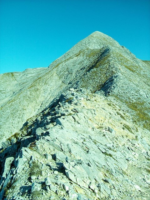
Il Monte Tambura è una montagna di 1895 metri, la seconda per altezza della catena delle Alpi Apuane, al confine tra la Provincia di Lucca e la Provincia di Massa e Carrara.
È compreso nel territorio del Parco naturale regionale delle Alpi Apuane.
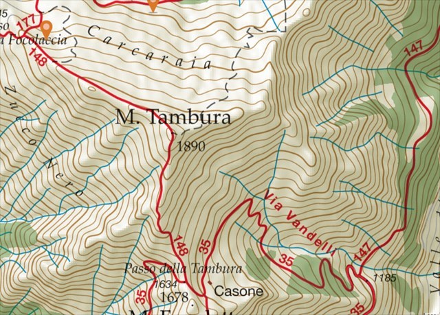
L'accesso dalla Garfagnana è più agevole, partendo dai 900 metri dalla località Arnetola, poco dopo il paese di Vagli di Sopra, comune di Vagli di Sotto.
Il percorso segue il sentiero 35, che in gran parte percorre la Via Vandelli e raggiunge il passo della Tambura.
Dopo il passo si prosegue per il sentiero di vetta.
Altro accesso: da Campocatino (1003 m), percorrendo il sentiero CAI 147 fino al raccordo con il 35 che sale al passo Tambura.
Per raggiungere dal lato della costa l'omonimo passo all'altitudine di 1634 metri, partendo da Resceto (frazione del comune di Massa che si trova a 465 metri di altitudine), possono essere utili la famosa Via Vandelli (vedi sentiero del C.A.I. 35), di facile percorrenza, che arrivava fino a Modena e altri sentieri che rimangono più a Nord, ma che sono più impervi e impegnativi (vedi sentieri del C.A.I. 166 e 166 bis).
Arrivati al passo, si lasciano questi sentieri e si prosegue con il sentiero di vetta (vedi sentiero del C.A.I. 148) per gli ultimi 350 metri di dislivello (Sentiero EE).
Dal Passo della Focolaccia, tramite il sentiero CAI 148, in direzione della Vetta Tambura.
La cache si trova 30 metri al di sotto della vetta accanto al sentiero che proviene dal Passo Tambura.
FATE MOLTA ATTENZIONE ----------------
Per raggiungere la cache si consiglia tassativamente una scarpa tecnica trekking
La cache si trova in prossimità del sentiero provieniente dal Passo Tambura dove si troveranno
tratti esposti, quindi fate molta attenzione - Si sconsiglia di intraprendere l'ascesa
con cattive condizione meteo o ghiaccio/neve
--------------------------------------------------------------------------------
--------------------------------------------------------------------------------
Monte Tambura is a mountain of 1895 meters, the second highest in the chain of the Apuan Alps, on the border between the Province of Lucca and the Province of Massa and Carrara. It is included in the territory of the Regional Natural Park of the Apuan Alps. Access from the Garfagnana is easier, starting from 900 meters from the town Arnetola, shortly after the village of Vagli di Sopra, municipality of Vagli di Sotto. The route follows the path 35, which mostly runs along Via Vandelli and reaches the Tambura pass. After the pass, continue on the summit trail.
Other access: from Campocatino (1003 m), along the CAI path 147 until the junction with the 35 that goes up to the Tambura pass.
To reach from the side of the coast the homonymous pass to the altitude of 1634 meters, starting from Resceto (a hamlet of the municipality of Massa which is located at 465 meters above sea level), the famous Via Vandelli can be useful (see CAI trail 35) , easy to travel, that came up to Modena and other paths that remain further north, but which are more impervious and challenging (see paths of CAI 166 and 166 bis). Arrived at the pass, you leave these paths and continue with the trail of the summit (see path of C.A.I. 148) for the last 350 meters in altitude (Path EE).
From Passo della Focolaccia, along the CAI path 148, towards Vetta Tambura. The cache is located 30 meters below the summit next to the trail that comes from the Passo Tambura.
MAKE MANY ATTENTION ----------------
To reach the cache, we recommend a technical trekking shoe
The cache is located near the path coming from the Passo Tambura where they will be exposed sections, so be very careful - It is not recommended to undertake the ascent with bad weather or ice / snow conditions
