The Knysna river estuary is more commonly known as the “Knysna Lagoon” which is technically incorrect. The Knysna River estuary measures 1633 ha in size and stretches almost 19kms from the river mouth known as "The Heads” to the Charlesford weir which marks the end of its tidal reach.
The catchment area of the estuary is about 350 square kilometres and the main source of fresh water is the Knysna River which at only 64 kilometres in length is quite small.
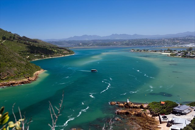
The view from the "Heads"
The difference between a lagoon and an estuary is often the subject of interpretation. In simple terms a lagoon is a shallow body of water separated from a larger body of water ( such as the sea ) by a shallow or exposed barrier. An estuary is a coastal water body where ocean tides and river water merge. Generally speaking lagoons tend not to be tidal and do not exhibit the combination of fresh and salt water.
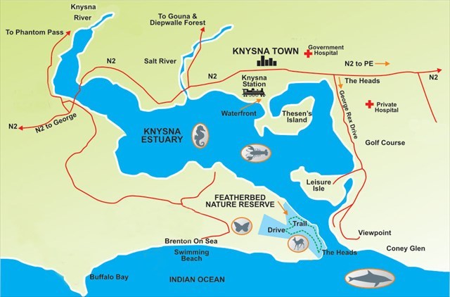
The layout of the Knysna River Estuary
To log this earth cache please answer the following questions and send an email to the cache organiser at the email address listed on his profile page. Any logs not supported by an email will be deleted.
1) At GZ over which part of an Estuarine regime do you think you are overlooking?
2) What do you think was the major factor behind the creation of this estuary ?
3) What evidence can you see from GZ to support the argument that this is an estuary rather than a lagoon ?
4) What is the name of the Viewpoint at GZ ? And by reading the Information Board near GZ concerning the “Knysna Lagoon’s” most famous resident, can you advise how many things / creatures is this famous resident likened to ?
5) Optional – send a picture of yourself and / or your GPS taken at GZ with the “Lagoon” / Estuary in the background.
So …… How on earth was this estuary formed ?
Todays Knysna River estuary is what geologists refer to as a “drowned valley”. Since the last ice age about 20,000 years ago the sea level has slowly been rising. It’s estimated that at that time ( 20,000 years ago ) which marked the height of the last ice age the sea level might have been as much as 120 metres lower. At that time there would have been no estuary merely a river valley through which the Knysna river meandered. Over the last 6,000 years the seal level has been fairly stable at current levels so we might expect the Knysna river estuary to have been in place for quite a while. It is however feared that with global warming a rise in the sea level might be accelerated so who knows what the future holds.
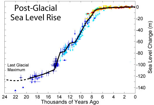
Sea level rise since the last Ice age
The Knysna River estuary can be broken down into three distinct sections ( regimes ):-
1) The Upper estuary regime – this area is strongly influenced by the inflow of fresh water from the Knysna river
2)The Lagoon regime – this is the middle area of the estuary and is characterised by aged salty water with little direct influence from freshwater. The lagoon is considered as a transition zone between the upper estuary and the marine embayment
3) Large marine embayment regime – this area is flushed by tidal flows and exhibits temperatures and salinities similar to the ocean.
These three areas demonstrate a high degree of temporal variability due in part to the large inflow of fresh water from the river system and the twice daily inflow of marine water through the Knysna Heads. During periods of high rain fall the freshwater regime can extend right into the marine regime with the virtual disappearance of the lagoon regime.
Estuaries are dynamic places that are always changing. The course of the river channel through the estuary can change over a season. Sediment eroded by the river is deposited in the estuary so that gradually, over thousands of years, the estuary becomes filled in, aided by salt marsh that grows out onto the sand and mud flats. On a geological time-scale, estuaries are “temporary” places.
Estuaries are vital habitats for thousands of marine species. Estuaries have been called the "nurseries of the sea" because the protected environment and abundant food provide an ideal location for fish and shellfish to reproduce. Most commercially important fish species spend some part of their life cycle in estuaries. Besides fish, many species of birds depend on estuaries for food and nesting areas. Migratory birds use estuaries as stopover points for resting and feeding before continuing their journey. Marine mammals also use estuaries as feeding grounds and nurseries. All these marine organisms feed in estuaries because a healthy estuary produces between 4 and 10 times as much organic matter as a cornfield of the same size. Estuaries provide a wide range of habitats leading to a great diversity of marine life.
The ”Knysna Lagoon” has one very special species resident in its water - Hippocampus Capensis. More information can be found out about this at GZ. There are only three estuaries in the world where this species is known to exist !
To put things into context:- The world's largest estuary is that of the Saint Lawrence river (which connects the Great Lakes to the Atlantic Ocean). A major portion of this estuary is in Canada, and the St Lawrence river has a length of over 1,900 miles ( from its headwater to its mouth ) The watershed of the estuary spans over half a million square kilometres.
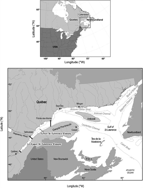
The Eastern seabord of Canada / USA ![]() The St Lawrence Estuary
The St Lawrence Estuary
Sources:
Knysna –South Africas favourite Town
https://www.nra.co.za/content/Final_EIR_20_Nov_09
https://serc.carleton.edu
https://www.researchgate.net
http://omp.gso.uri.edu/ompweb
www.pixabay.com