
The learning point of this earthcache is to get the geocacher to become familiar with the coastal landform Spits.
(After I came over this theme a while back in time I got inspired and since then had an eye out for a nice sample to make a earthcache of. Other examples that has been inspiring: GC4E0CB, and GC2EXX1)
The coordinates will lead you to the view from the spits at Sutton end, you can also visit from the other side added as a WP, both sides will be a beautiful view to the eye.
On your way in you will meet a barrier so cars can not get in, but there's also a "path" next to the road that goes to the end of the spits accessible by walking. Informed by the staff at the location.
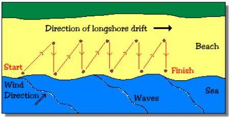
The Spit formation sticks out from the mainland like a tongue, it has been made by the wave sedimentation mechanism, and by studying the wave and longshore drift at the location you will better understand the text under where the whole phenomenon has been explained in detail.
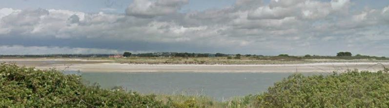
A Spit is a stretch of beach at one end of a coastline caused by waves depositing material. It is connected to the mainland at one end. A spit thus has two ends. The end jutting out onto the water is called the distal end, and the one attached to land is called the proximal end.
Spits are usually formed when longshore currents producing a longshore drift strike the beach at an angle. This usually happens in the case of a sheltered beach or shore like that of a bay or cove. As the longshore current moves at an angle, and changes direction, the current spreads out and loses much of its energy. The dissipation of energy renders the waves incapable of carrying a full load of sediments, and thus sediments are deposited in the form of a long bar-like feature off the coast or shore of the mainland. In this way, a spit is formed.
It may grow on:
As the longshore drift will continue to deposit sediments where the waves are breaking, the spit will continue to rise. The spit will also continue to extend into the sea but not indefinitely. The process stops when water pressure, like that from a river draining into the ocean, is too high to allow the sediment deposition to continue to occur.

A spits habitat:
Over the years, life begins to bloom on a spit. Vegetation starts growing, and the spit might also become a fertile landform in the future. The water behind the spit landform is sheltered from wind and wave action, and this results in a salt marsh habitat. Such habitat allows the growth of only salt-tolerant vegetation and often attracts birds to them.
New formations:
A Spit can actually give rise to a new landform, coastal formation. If there is an island in the vicinity of the spit, and the spit grows in a manner that it connects the islands to the mainland, the connecting feature is called a tombolo. A spit might also continue to grow in length and join mainland at the other end. The newly created landform which is joined at both ends to land is called a bar. The part of the sea behind the bar is a lagoon.

To log this cache.
To get to log this cache you will have to visit and answer the questions which are related to the coordinates given the earthcache.
When answers are collected, send them to CO for verification.
You can log immediately after answers are sent CO. If there are any questions about your answers CO will contact you.
Logs without answers to CO or with pending questions from CO will be deleted without any further notice.
Please do not include pictures in your log that may answer the questions.
Questions
1. Answer the questions under by visiting the Coordinates.
A. 1.) What type of sediments can be found in the area around the given coordinates that is affected by the longshore drift? And what is its typical size? 2.) How would you describe the transition from the spit formation and further on to the habitat?
B. Describe the habitat of the Spits?
C. How wide is the Spit on its smallest (nose) part and biggest (body) part?
D. A Spit can actually give rise to a new landform, out of the three mentioned above in the text, what one is the only one that could take form as a new one here at this location?
2. (It’s voluntary to post a photo in your online log of your visit)
Without revealing any answers!
