
“Life is difficult. This is a great truth, one of the greatest truths. It is a great truth because once we truly see this truth, we transcend it. Once we truly know that life is difficult - once we truly understand and accept it - then life is no longer difficult. Because once it is accepted, the fact that life is difficult no longer matters.”
“We must be willing to fail and to appreciate the truth that often 'Life is not a problem to be solved, but a mystery to be lived.'”
― M. Scott Peck
The Journey
The reservation for the Healesville Freeway was incorporated into the Metropolitan Transport Plan in 1969 and originally extended from Riversdale Road, Box Hill South, to Maroondah Highway, Coldstream. Sections of the reservation at both ends of the route have since been released. Only recently has this section between Springvale Road in Forest Hill and Boronia Road in Vermont been formally transferred from VicRoads to Parks Victoria with the view to renaming it as community parkland. You can follow the progress on the Victorian Government website and subscribe to updates from Parks Victoria. Current media release (August 22, 2025): Delivering the Best New Urban Park in Melbourne.
There is something unexpected and appealing about wandering along this narrow, hidden track through the suburbs. The idea of choosing "the road less traveled" seems to typify the geocaching experience, and the themes of each cache in this series draw their inspiration from M. Scott Peck’s best selling book of the same name, which outlines the steps towards a personal journey of discovery.
If you complete all 5 caches together on foot, you will have covered approximately 2.6 km by the time you return to the starting point.
***SEPTEMBER 2019 UPDATE***
Work is underway to open up access to the reserve. All old horse fencing has been removed in this stretch, and there are numerous muddy tracks left by diggers as part of the process.
***SEPTEMBER 2023 UPDATE***
Park plan finalised with details available via the Victorian Government and Parks Victoria websites.
***APRIL 2024 UPDATE***
 .
. 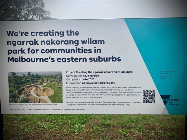
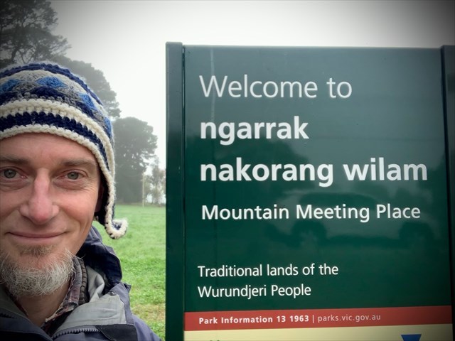
The park's name has been announced as ngarrak nakorang wilam park, with work commencing later this year. The name means 'Mountain Meeting Place' and was chosen by the Wurundjeri Woi Wurrung Cultural Heritage Aboriginal Corporation. The corporation represents Traditional Owners of these lands, the Wurundjeri people, and has been a key stakeholder in planning for this park.
The Cache
Embrace the mystery of life and accept that at times, Life is difficult!
Final coordinates are:
S 37 50.SOUTH E 145 11.EAST
SOUTH = (S x 15) + L
EAST = 3 x (V - C) + L
Check your coordinates below via the checksums or the solution checker.
You are looking for a 1L sistema. BYO pen.
TIP: Easiest access is to leave the path at cache {4} and navigate through the woods
***CONGRATULATIONS to Geo_Seek and jaktembo on the joint FTF***
The Series
👣 GC82M8G The Road Less Traveled {1} Courage, once more
👣 GC7ZT6T The Road Less Traveled {2} See
👣 GC7ZT6W The Road Less Traveled {3} Listen
👣 GC7ZT6Y The Road Less Traveled {4} Love
👣 GC7ZT70 The Road Less Traveled Final {5} Life
Traveller Souvenir - 12 caches found
If you have completed 12 caches along the Healesville Freeway Reserve, comprising The Road Less Traveled Series (5 caches), Roads Go Ever Ever On Series (6 caches) and Magic Spell (1 cache), you might like to add the following souvenir to your profile:
To add the souvenir, go to your profile page and click on the cog icon top right. Paste the following HTML code into the “About” box:
<br /><a href="https://coord.info/GC82M8G" target="_blank"><img src="https://s3.amazonaws.com/gs-geo-images/e0fa7a3d-c5be-482b-926d-d0f54fc47305.png" width="200" height="200" /></a><br />
Check Coordinates
Checksum SOUTH = 17
Checksum EAST = 11
“Gone but not forgotten”
In memory of another cache that was once also here:
GC3732P The Landed Gentry
November 2, 2011 - December 26, 2014