This is an EarthCache and has special requirements for logging it. You cannot log a Found It without responding to the logging requirements set out below.
Only one find claim per Message. Each Geocacher claiming a find must submit an individual response. One team can not lodge a response on behalf of a group of people.
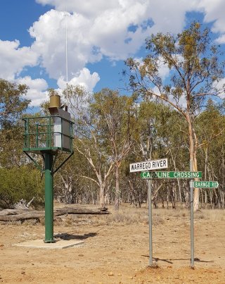
This Earth Cache is located where Caroline Crossing Road crosses the Warrego River. Caroline Crossing is a locality rather than an actual river crossing per se. There is a traditional cache nearby called One River: "Sweet Place" which was the original reason we visited this spot. So why an Earth Cache?
What is the relationship between river systems and geology?
By eroding sediment from uplifted areas (hills), transporting and depositing said sediment thereby creating landforms made of deposited sediment in lower areas, river systems (often called streams) shape the earth’s surface more than glaciers do, more than waves on a beach do, and far more than wind does.
Streams flow downhill due to the force of gravity. The higher the hill, the more gravitational energy there is to drive the stream. Where the slopes are steepest and the hills the highest, the streams will be the most energetic and the rate of erosion will be fastest. Such processes cause much erosion and transportation.
Warning systems are now in place at strategic points along most of Queensland's outback rivers, and this isolated spot is no exception.
Most rocks and minerals are much denser than water. Sufficient energy in the stream is required to dislodge rocks from the earth and move them. The faster a stream flows, the more energy it has and the larger pieces of sediment it can transport. The competence of a stream refers to the maximum size of the pieces of sediment it can move. Faster-moving water has greater competence and can move larger pieces of sediment.
The capacity of a stream is the total amount of sediment it can move. Capacity depends on how fast the stream is moving and its total discharge. As a stream slows down, its competence and capacity are reduced. The stream starts to deposit sediment, beginning with the largest pieces.
Streams transport clastic (rocks composed of fragments, or clasts, of pre-existing minerals and rock) sediment in two ways depending on the size of the particles. The coarser sediment is called bed load and consists of particles too large to be suspended in the moving current of water for an extended length of time. The bed load particles, the largest particles of sediment transported by a stream, spend most of their time on the bottom of the stream channel, rolling, sliding, or bouncing downstream in fits and starts. The finer sediment is called suspended load and consists of particles small enough to be suspended in the moving current of water. Suspended load moves at about the same rate as the flowing water. In a muddy river, the mud is suspended load.
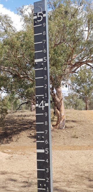
The Warrego River, for the most part of the year (or years) is a dry river system - in geological terns, it is called an Ephemeral streams as it is a watercourses that does not have surface water flowing for the entire year. It is possible to walk the bed of the Warrego River in these lengthy dry periods. But, when the water does flow, it is due to heavy rains.
To log a Found It  on this cache, you need to answer the following questions:
NOTE: Do not attempt this earth cache if the river is flowing!
- Describe the bed load in the river.
- Based upon your observations and answer to the above question, how could you rate the competence of the river in flood times?
- Where can you see evidence of a suspended load carried by the river?
- Take of photo of yourself OR your GPS to show a view of GZ. Include it in your message, but please do not post it in your log, it might give too much away.
When you have your response to the above questions, please, if possible, MESSAGE us, using the link at the top of the page underneath the name of the Cache. We prefer the MESSAGE method, as apparently, we don't respond to emails very well, but messages we do. We will contact you by MESSAGE once your MESSAGE has been received. But you can log your find in the meantime, and just say that you have MESSAGED your answers to the COs.
You may log your Found It at any time, but if there is a problem with your answers, you will receive further correspondence.
Happy Earthcaching!