(English below)
中文
长江 我 是6,380 公里(3,964 mi)长, 成为第三 个最长 世界上的 河流 和 亚洲 最长的 河流 。 它也是 一个国家内 最长的河流 。
不像 黄河 进一步北部, 已 广泛波动北部和山东 半岛 南部 ,长江基本上保持静态 最近( 即 在过去的 1 0 million年 左右 )。 但是,无论是否波动,河流都倾向于从同一个方向流动 - 从山脉到大海。 这使它们成为我们称之为侵蚀的重要因素。 实际上 , 河流中 存在 三种主要类型的 相关过程: 侵蚀,运输和沉积。
侵蚀
水流通过从 床和堤岸 取材来引起侵蚀 。 随着时间的推移,T 他把这条河 更宽,更深,时间更长 的山谷头 。
运输
被侵蚀的材料沿河流运。 运输可分为四个过程: 可溶性或腐蚀性物质在溶液中运输,小颗粒在悬浮液中运输。 在河床中,颗粒可以在称为盐化的过程中短距离运输,因此材料像沙丘一样穿过沙漠。 最后,较大的物体只是沿着床移动,称为牵引。
沉积
沉积是 运输停止 的过程 。 这种情况发生在 水体积更少由 降雨, 更 蒸发,摩擦靠近河岸和 降低的流动速度进一步 降低 下来的河流。 当河流与大海相遇时 ,流速最终会降低 。 沉积的物质也会使河流在 河口 变 长 ,因为 沉积物会使海水变浅。 这最终 结果 S 在具有 从海底 上升 N,在延伸增量的形式 平坦的土地 。
该 Hjulström 曲线
交通中的中心数量因素 是河流的能力和能力。 能力是河流 可以 承载 的最大负荷 , 而容量是河流可以运输的物质总量。 河流的能力 可以通过 河流在 特定点 运输 的 最大粒度 来衡量 。 所述 Hjulström 曲线示出 对于给定的密度 水流 速度和 颗粒大小 之间的关系 。 黑线独立的区域,其中 沉淀 为,运输或沉积: 的 侵蚀曲线表示 侵蚀(拾取)所需的河流 的最小 流速 和不同大小的传输材料(例如,如泥沙或悬浮液中)。 与仅运输材料相比,需要更大的速度来侵蚀材料。 沉积 曲线 在其中不同尺寸的颗粒 开始沉降 的 流动速度 。
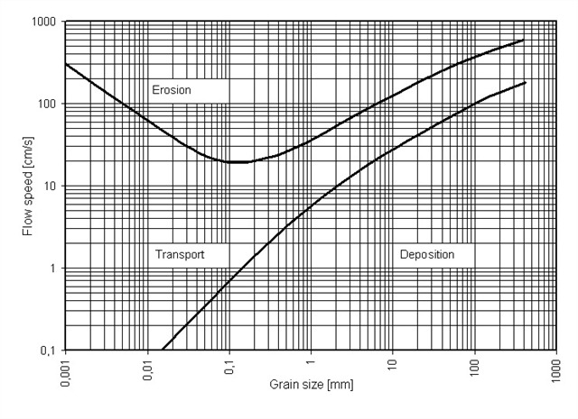
Hjulström曲线 - 资源: http://commons.wikimedia.org/wiki/File:Hjulströms_diagram_en.PNG
在长江口,流速 很低 ,沉积是相关过程,多年来形成了三角洲周围的所有土地(好吧,数百万年)。 然而,最近的数据表明,发展带来了急剧的转变: 三角洲前沿在20世纪60年代和70年代每年积累了大约1.25亿立方米的沉积物,但现在每年的侵蚀量约为1亿立方米。 其原因 在于上游,整个长江流域竖立了大约50,000座大坝,这些大坝阻挡了沉积物。 一个关键的角色扮演三峡大坝,这是在2003年关闭的侵蚀可能会增加,进一步水坝 计划 , 南 到北分水岭建立。 目前大多数侵蚀的水深为5至8米,较浅的区域暂时保持相对稳定。
这个缓存就在这里,因为它是一个特别好的 访问 地点 ,而且 看到我不喜欢的地方是我寻址的主要原因之一。 这个 地方 也是 一个中间 缓存 沙漠-下一个高速缓存大约 两个小时的车程,在上市时间。
以下是您如何记录: g o到 已发布的合作 伙伴 。 这应该很 容易 , 地形评级是 Ë 疗法 是有 原因的 。 N}÷需要涉水 入河或走出冰 ,只是利用现有的结构 。 如果位置似乎 在水中 更远 ,您可能正在使用实时数据进行导航。 出于某种原因,坐标是时常 关闭在中国西部。 如果发生这种情况,请尽可能靠近河流,在张贴的纬度。 在 平台 头Ÿ 欧 看到 相关的 迹象 正侵蚀 。 如果 你 了解中文 ,我 告诉你a)这条河比你强得多,b)在受到挑战时会像对待任何其他沉积物一样对待你。 当您注意到此缓存描述时,您已经知道了。 请找到方向并计算该行文本中的汉字。 作为提示,只有六个方向。 他们是北 北 ,南 南 ,东 东 ,西 西 ,截至 上 ,和下 下 。 标志上 只有一个 字符。 此外, 我可以告诉你 它不是“向上”,因为 它 没有地质 相关性 - 这是一个地球缓存。 不涉及航空或天文学。
当你找到 合适的角色时 ,请在不违反地形等级的情况下向这个方向走。 大约 是行中字符数的 五倍 。 你会发现一块你不应该爬的大石头。
当您找到岩石时,回答以下问题 并通过 电子邮件 发送给我 :
1. 你可以看到河 对岸 ? (是/否)。 E 激发 或猜测 该点处河流的宽度, 平台高于水位的高度,以及灯塔与标志上方向之间的角度。
2. 描述岩石的拓扑结构(即形状),以及它是什么样的岩石。 如果你不知道,做一个有根据的猜测。 它是一种当地的岩石,还是人类从其他地方带来的? 让我知道你为什么这么认为。
3. 什么会 继续 侵蚀 做河岸 ? 一个 再有 人造结构来影响日 是什么?
4. 你可以使用 上面 的 Hjulström 曲线来解释长江从沉积如何去三角洲地区水土流失近年 ?
您可以立即登录 ,如果有问题我会与您联系 。 请 发表 PIC TURE 的您的光临 。 这不是一项要求,您无需在图片中识别,但我们非常感激。 感谢在某种程度上创造它的创意。 并且请 确保 不要发布任何剧透,特别是没有标志或岩石的图片。 我会遗憾地删除它们,但一致性。
有些中国人的习惯,你应该知道的,特别是在黑暗中去的时候(这是 真正的黑 有 在 黑暗 中 ):
他们喜欢通过切换任何灯来扩展电动滑板车
他们喜欢锁定可从任何一侧进入的大门,但需要花一英里才能到达
他们喜欢在人行道上保留一块混凝土块供以后使用
蚊子的习惯不是特别中国人,他们就像其他人一样喜欢吃饭。
奖励:通过 岩石几步(大约40米), 左边 一条废弃的 路径 将带你到一个 隐藏在植被中 的迷失的地方 ,但很容易接近 。 去那里 时要 小心,特别是 在单独 旅行 和/或爬到山顶和/或在黑暗中行走时。 我 绝对到 这种事情,我也知道很多同行 人也有同感。 该地区正在开发中,因此这个地方可能很快就会丢失,请告知我这种情况。
个人注意:我追求跨境缓存的个人挑战,我 只是在它 位于 我们国家与我以前的日志不同的状态 时才 尝试 登录缓存 。 有一些讽刺意味的是,这个缓存 - 这是我的第一个 - 具有非跨越河流的主题。 但是,由于扬子没有记录任何缓存,我认为它遵守规则。 无论如何,如果你跨越日志这个缓存,我可能会给你一个荣誉提名。 条件:先前和下次登录不在中国。
最后一个字(对不起,几个):长江三角洲标志着由纯粹的压倒性缺乏 无论 是清新的空气和水的价值 。 请不要做任何使情况变得更糟,更轻微的活动。 留在小径上甚至不留脚印,只留下记忆,照片和公共交通工具。 南通不值得去任何地方旅行,但如果你碰巧在这里,这个 地球缓存 可能会有点安慰。
English
The Yangtze 长江 is 6,380 km (3,964 miles) long, making it the third-longest river in the world and the longest in Asia. It is also the longest river that never crosses a single state border.
Unlike the Yellow River further north, which has fluctuated widely north and south of the Shandong peninsula, the Yangtze has remained largely static recently (i.e. for the past 10 million years or so). But fluctuating or not, rivers tend to flow in the same direction – from the mountains to the sea. This makes them an essential factor in what we call erosion. Actually there are three main types of relevant processes that occur in a river: erosion, transportation and deposition.
Erosion
The flow of water causes erosion by taking material from the bed and banks. Over time, this makes the river wider, deeper and longer at the valley head.
Transportation
Eroded material is carried down the river. The transportation can be categorized in four processes: soluble or corroded material is transported in solution, small particles in suspension. In the river bed, particles can be transported over short distances in a process called saltation, so the material moves like a dune through the desert. And finally, larger objects are simply moved along the bed, which is called traction.
Deposition
Deposition is the process when transportation ceases. This happens when the water volume decreases by less rainfall, more evaporation, friction close to river banks and reduced flow speeds further down a river. The flow speed ultimately reduces when a river meets the sea. The deposited material also makes the river longer at the mouth, as the sea becomes shallower with the deposit. This ultimately results in flat lands that have risen from the ocean floor, in the form of an extending delta.
The Hjulström Curve
Central quantitative factors in transportation are competence and capacity of a river. The competence is the maximum load a river can carry, whereas capacity is the total volume of material a river can transport. The competence of a river can be measured by the maximum particle size a river can transport at a particular point. The Hjulström curve shows the relationship between water flow velocity and particle size for a given density. The black lines separate areas where sediment is eroded, transported or deposited: the erosion curve shows the minimum flow speed needed for the river to erode (pick up) and transport material of different sizes (e.g. as bedload or in suspension). A greater velocity is required to erode material compared to just transporting it. The deposition curve shows the flow speed at which different sized particles begin to settle.
Hjulström Curve - source: http://commons.wikimedia.org/wiki/File:Hjulströms_diagram_en.PNG
Here in the Yangtse estuary, flow speed is low and deposition was the relevant process, forming all the land in the delta around you over the years (well, millions of years). Recent data, however, show that development brought a sharp turnaround: The delta front accumulated about 125 million cubic meters of sediment in the 1960s and 1970s per year, but now sees an erosion of about 100 million cubic meters per year. The reason for this is that upstream, about 50,000 dams were erected throughout the Yangtse watershed, which hold back sediment. A key role plays the Three Gorges Dam, which was closed in 2003. The erosion is likely to increase, as further dams are planned and the South-to-North-watershed is built. Most erosion is currently at water depths from 5 to 8 meters, with shallower areas remaining relatively stable for the time being.
This cache is here as it is a particularly nice place to visit, and seeing spots I otherwise would not is one of my primary reasons for geocaching. This place is also in the middle of a caching desert – the next cache is about a two-hour drive away at the time of listing.
Here is how you log: go to the posted coordinates. This should be easy, the terrain rating is there for a reason. No need to wade into the river or step out on the ice, just make use of the existing structure. If the location appears to be further out in water, you are probably navigating with live data. For some reason, coordinates are oftentimes off to the west in China. If that happens, go as close to the river as you can at the posted latitude. At the platform head you see an erosion related sign. If you understand Chinese, it tells you that a) the river is much stronger than you and b) will treat you like any other sediment when challenged. As you paid attention to this cache description, you already know that. Please find the direction and count the Chinese characters in that line of text. As a hint, there are only six directions. They are North 北, South 南, East 东, West 西, Up 上, and Down 下. There is only one of the characters on the sign. Also, I can tell you it is not “up”, as it has no geological relevance – this is an earth cache. No aviation or astronomy involved.
When you found the right character, please walk in that direction as well as you can without violating the terrain rating. Take about five times as many steps as there are characters in the line. You will find a large rock you are supposed not to climb.
When you found the rock, please answer the following questions and send them to me by email:
-
Can you see the far bank of the river? (Yes/No). Estimate or guess the width of the river at the point, the elevation of the platform above water level, and the angle between the light tower and the direction found on the sign.
-
Describe the topology (i.e. form) of the rock, and what kind of rock it is. If you do not know, make an educated guess. Is it a local rock, or was it brought from somewhere else by humans? Let me know why you think so.
-
What will continued erosion do to the river bank? Are there man-made structures to influence this?
-
Can you use the Hjulström curve above to explain how the Yangtze went from deposition to erosion in the delta area in recent years?
You can log right away, I will contact you if there is an issue. Please post a picture of your visit. This is not a requirement and you do not have to be recognizable in the picture, but it is really appreciated. Kudos for making it creative in a way. And please make absolutely sure not to post any spoilers, particularly no pictures of signs or the rock. I will delete them with regret, but consistency.
Some Chinese habits you should be aware of, particularly when going in the dark (it is really dark there in the dark):
- they like to range extend electric scooters by switching of any lights
- they like to lock gates that are accessible from either side, but take a mile to get around
- they like to keep a cache of concrete blocks on the pavement for later use
The mosquito’s habits are not particularly Chinese, they like a good meal just like everybody else.
Bonus: a few steps (about 40m) past the rock, a derelict looking path to the left will take you to a lost place that is hidden in the vegetation, but quite accessible. Take care when you go there, particularly when going alone and/or climb to the top and/or go in the dark. I am definitely into this kind of thing and I know many fellow Cachers are too. The area is being developed and so this place may soon be really lost, let me know when this is the case.
Personal note: I pursue the personal challenge of cross-border-caching, where I try to log a cache only when it is located in a state our country different from my previous log. There is some irony in the fact that this cache – which is my first – has a non-border-crossing river theme. However, as the Yangtze does not log any caches, I think it adheres to the rules. Anyway, if you cross-border log this cache, I may give you an honorable mention. Condition: prior AND next log NOT in China.
One last word (sorry, several): The Yangtze delta signifies the value of clean air and water by the sheer overwhelming lack of either. Please do refrain from any activity that makes a bad situation worse, ever so slightly. Leave not even footprints by staying on the trails, and take nothing but memories, photographs and public transport where possible. Nantong is not worth a trip from anywhere, but if you happen to be here, this Earth Cache may be a little comfort.