French and English in the text 😉
Une Earthcache un peu différente des autres ; celle-ci ne vous parlera pas de volcanologie, de minéralogie, de roches karstiques ou encore d’orgues basaltiques. Le focus sera plutôt mis sur un aspect géologique de base de notre TERRE : ELLE EST RONDE !, et de nos jours il n’y a plus beaucoup de monde pour dire le contraire.
An Earthcache a little different from others; it will not speak to you about volcanology, mineralogy, karstic rocks or basaltic organs. The focus will rather be on a basic geological aspect of our EARTH: IT IS ROUND !, and nowadays there are not many people to say the opposite.
En fin d’après-midi, de nombreuses personnes s’arrêtent sur les plages de la côte ouest afin de jouir de la vue du soleil couchant, ceci jusqu’à ce qu’il disparaisse à l’horizon.
Mais à quelle distance se situe exactement l'horizon ? A quelques kilomètres ? A quelques dizaines de kilomètres ? A l’infini ?
In the late afternoon, many people stop for a moment on the beaches of the west coast to enjoy the view of the sunset, until it disappears on the horizon.
But how far is the horizon exactly? A few kilometers? A few tens of kilometers? To infinity ?
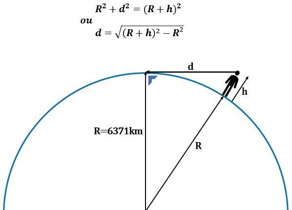
En fait la réponse dépend de la hauteur du point de vision. C’est mathématique.
Considérons un observateur de hauteur h, sur la Terre de rayon 6371 km. A quelle distance d se situe l’horizon ?
La ligne de vision est une tangente à la courbure de la Terre, et donc le fameux théorème de Pythagore s'applique :
In fact, the answer depends on the height of the point of vision. It's mathematical.
Consider an observer of height h, on the Earth radius 6371 km. How far is the horizon?
The line of vision is a tangent to the curvature of the Earth, and so the famous Pythagorean theorem gives us:
Imaginons que le point de vision de l’observateur se situe à 2 mètres de hauteur (2 m = 0,002 km), son horizon se situe alors à une distance d :
Imagine that the viewpoint of the observer is 2 meters high (2 m = 0.002 km), his horizon is then at a distance d:

Avec le même raisonnement, on comprend qu’on peut observer un point qui se situe derrière la ligne d’horizon pour autant qu’il ait la hauteur suffisante.
Les phares maritimes par exemple peuvent être vus à plus de 5 kilomètres par l’observateur en mer.
With the same reasoning, we understand that we can observe a point that lies behind the horizon line if it has sufficient height.
Maritime lighthouses, for example, can be seen more than 5 kilometers away by the observer at sea.
Pour loguer la cache, il vous faut répondre aux questions ci-dessous :
- La ligne d’horizon est-elle une droite ou une autre forme ? Expliquez
- Si on monte au sommet du Pic de la Petite Rivière Noire, le plus haut sommet de Maurice, qui culmine à 828 mètres au-dessus du niveau de la mer, à quelle distance approximative se situe en théorie l’horizon par temps clair ?
- Toujours au sommet du Pic de la Petite Rivière Noire, peut-on théoriquement voir l’île de la Réunion, sachant que le point culminant en est le sommet du Piton des Neiges à 3070 mètres.
- Facultatif : postez une photo de votre horizon, éventuellement pris d’un sommet de l’ile (Le Morne, Le Pouce, le Pic de la Petite Rivière Noire, …) ou simplement pris depuis la plage.
To log the cache, you need to answer the following questions:
- Is the horizon line a straight line or another shape? Explain.
- If you ascend to the summit of Little Black River Peak, the highest peak in Mauritius, which rises to 828 meters above sea level, how far in theory is the horizon on a clear day?
- Still at the top of the Little Black River peak, can we theoretically see Reunion Island , knowing that the highest point is the summit of the Piton des Neiges at 3070 meters.
- Optional: post a photo of your horizon, possibly taken from a summit of the island (Le Morne, Le Pouce, Little Black River peak, ...) or simply taken from the beach.
Envoyez-moi vos réponses par message privé, et pas besoin d’attendre une réponse pour loguer.
En revanche les logs sans message seront supprimés.
Send me your answers by private message, and no need to wait for an answer to log.
On the other hand, logs without message will be deleted.
Amusez-vous ! Have fun !
Note : J’ai volontairement laissé la cache à un endroit très accessible, mais évidemment rien ne vous empêche de monter jusqu’à un sommet pour vérifier tout ceci 😊
Note: I voluntarily left the cache in a very accessible place, but obviously nothing prevents you from climbing to a summit to check all this 😊
