Skip to content

LIMES - CĂLUGĂRENI/MIKHÁZA Traditional Cache

Hidden : 1/1/2019
Difficulty:
1.5 out of 5
Terrain:
1.5 out of 5

Size: Size:   small (small)

Join now to view geocache location details. It's free!

Watch

How Geocaching Works

Please note Use of geocaching.com services is subject to the terms and conditions in our disclaimer.

Geocache Description:


[EN] ROMAN LIMES

     The word limes was used by Latin writers to denote a marked or fortified frontier. This term has been adapted and used by modern historians as an equivalent for the frontiers of the Roman Empire.  Even if it is widely used, nowadays we know that the term limes became common only after the third century, when it denoted a military district under the command of a dux limitis.

     The Roman Limes represented the border line of the Roman Empire at its greatest extent in the 2nd century AD. It stretched over 5,000 km from the Atlantic coast of Scotland, through Europe to the Black Sea, and from there to the Red Sea and across North Africa back to the Atlantic coast. The remains of the limes today consist of remnants of built walls, ditches, forts, fortresses, and civilian settlements. Certain elements of this defensive line have been excavated, some reconstructed, but many were destroyed. It’s an outstanding example of the Roman military organization and illustrates the defensive techniques and geopolitical strategies of imperial Rome.

[RO] LIMESUL ROMAN

     Autorii latini au folosit termenul de limes pentru a defini o porţiune de graniţă marcată sau întărită. Istoricii contemporani utilizează acest termen referindu-se la ansamblul sistemului de apărare al graniţelor Imperiului Roman. Deşi astăzi noţiunea este bine înrădăcinată în conştiinţa publică, termenul de limes s-a răspândit abia după sec. al III-lea d. Hr., când a început să fie folosit pentru a denumi o structură administrativ-militară condusă de un aşa-zis dux militis.

     Limes-ul, ca graniţă a Imperiului Roman, a avut cea mai mare întindere în sec. al II-lea d. Hr., având o lungime de peste 5000 km. Începând de la malul atlantic al Scoţiei, acesta a străbătut întreaga Europă, a atins Marea Neagră și a continuat până la Marea Roşie, a parcurs nordul Africii, pentru a ajunge înapoi la malul Oceanului Atlantic. Urmele limes -ului (ziduri, şanţuri, turnuri de observație, fortificaţii şi clădiri civile) au fost parţial dezvelite, conservate sau reconstruite, însă, în marea lor majoritate, nu au rezistat trecerii timpului. Acest ansamblu impozant de structuri complexe exemplifică într-un mod unic structurile militare, instalaţiile defensive, cât şi strategiile geo-politice ale Romei imperiale.

[HU] RÓMAI LIMES

     A latin szerzők a limes szót a megjelölt vagy megerősített határszakasz megnevezésére használták. A modern kor történészei e kifejezést a Római Birodalom határvédelmi rendszerével tették egyenértékűvé. Habár e megnevezés mára teljesen beépült a köztudatba, a limes, határvonal értelemben, csak a III. század után terjedt el, amikor egy olyan katonai körzet megjelölésére használták melynek az élén egy dux limitis állt.

     A limes a Római Birodalom határaként a Kr.u. II. században érte el legnagyobb kiterjedését. Ekkor több mint 5000 km hosszan húzódott a mai Skócia Atlanti-óceáni partvidékétől, Európán át a Fekete-tengerig, ahonnan a Vörös-tengert érintve Észak-Afrikán keresztül újra elérte az Atlanti-óceánt. A limes maradványainak (falak, árkok, őrtornyok, erődítmények és polgári települések) egy részét napjainkig feltárták, konzerválták vagy újjáépítették, jelentős részük azonban megsemmisült. E kimagasló létesítmény-együttes kiválóan példázza a birodalmi Róma hadászati struktúráit és védelmi berendezéseit, valamint geopolitikai stratégiáit.

The Roman Empire (Map made by the FRE Culture 2000 project)

[EN] THE EASTERN LIMES OF DACIA

     At the moment twelve auxiliary camps are known on the eastern limes of Dacia (Liveziile, Orheiul Bistriţei, Brâncoveneşti, Călugăreni, Sărăţeni, Inlăceni, Odorheiu Secuiesc, Sânpaul, Olteni, Comalău, Boroşneu Mare and Breţcu) and scholarship presumes the existence of two other (Gurghiu and Baraolt). In the vicinity of these camps, civilian settlements (vicus) came into existence, which were the most important religious, economic and cultural centers of the area in the Roman period. The communication between the forts and their supply was achieved through a road (limes road) running parallel to the border, which is known only in short sectors. The control and protection of this border section was achieved through a complex system of watchtowers and outposts as well as ditches and ramparts used to block the valleys. Such towers are documented in the territories of the settlements of Băile Homorod, Ocland, Păuleni, Eremitu, Ibăneşti and Chiheru de Jos.

[RO] LIMESUL ESTIC AL DACIEI

     În prezent, de-a lungul limes-ului estic al Daciei, sunt cunoscute douăsprezece tabere în care au staționat trupele militare auxiliare (Livezile, Orheiu Bistriţei, Brâncoveneşti, Călugăreni, Sărăţeni, Inlăceni, Odorheiu Secuiesc, Sânpaul, Olteni, Comalău, Boroşneu Mare, Breţcu) și avem indicii asupra existenţei altor două (Gurghiu, Baraolt). În jurul acestor tabere militare romane au fost întemeiate aşezări civile (vicus-uri) care au funcționat ca importante centre religioase, economice şi culturale ale regiunii. Comunicarea între tabere şi aprovizionarea trupelor militare a fost realizată print-un drum al limes-ului, paralel cu traseul graniţei, pe care, în momentul de față, îl cunoaștem doar pe porţiuni scurte. Paza şi protecţia sectorului de graniţă a fost asigurată printr-un sistem complex compus din şanţuri şi valuri de pământ, turnuri de pază şi de semnalizare. Astfel de turnuri sunt cunoscute la Homorod-Băi, Ocland, Păuleni, Eremitu, Ibăneşti şi Chiheru de Jos.

[HU] DÁCIA KELETI LIMESE

    Jelenleg tizenkét segédcsapat tábor ismert Dácia keleti limesén (Jád, Óvárhely, Marosvécs, Mikháza, Sóvárad, Énlaka, Székelyudvarhely, Homoródszentpál, Oltszem, Komolló, Nagyborosnyó, Bereck), és kettő létét (Görgényszentimre, Barót) feltételezi a kutatás. A táborok mellett alapított települések (vicusok) az említett régió legjelentősebb vallási, gazdasági és kulturális központjai voltak a római korban. A táborok közti kommunikációt és a csapatok ellátását egy a határral párhuzamosan haladó út (limes út) révén valósították meg, melynek csak rövidebb szakaszait ismerjük. A határszakasz felügyeletét és védelmét völgyzáró sáncok és egy komplex őr- és jelző-torony rendszer révén valósították meg. Ilyen tornyokat ismerünk Homoródfürdő, Oklánd, Székelypálfalva, Nyárádremete, Libánfalva és Alsóköhér határából.
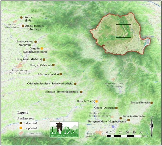
The eastern limes of Roman Dacia (Map made by M. Szabó)

[EN]PROJECTS

    During the research of the roman defensive system (limes) from Mureş County the need to preserve and present the sites belonging to it emerges. In 2012 the Mureş County Museum initiated the ROMAN LIMES ROUTE project. In 2013 the second stage of this cultural project financed by the Administration of the National Cultural Fund (AFCN) and the Mureş County Council started already. The aim of the project is to identify new sites along the limes section found on the territory of Mureş County, and the thorough mapping of the already known sites with the help of field walking, aerial photography and geophysical surveys. The processing of the GIS data allows a more exact definition of the extent of the sites to be protected and their presentation.

     On one hand, our hope is that, through the propagation of the sites pertaining to the limes and the collaboration with the local community the further destruction of these sites can be prevented. On the other, it becomes possible to work out strategies which aim to utilize the limes for touristic purposes. We wish to present the limes in the form of an itinerary, which we plan to familiarize with the visitors through free maps and a brochure as well as through the more detailed information published on the web page of the project. Marked tourist tracks and signposts would guide the visitors to the locations that are more difficult to access; about the sites explanatory boards would furnish information.

     Along the limes section in Mureş County three auxiliary camps are known (Brâncoveneşti, Călugăreni şi Sărăţeni), in the vicinity of which settlements (vicus) were established, where next to the families of soldiers, merchants and craftsmen servicing them had settled. The camps were connected by the limes road thus facilitating the supply and the fast movement of the troops. The duty of the soldiers stationed here was the protection of the border running parallel, which was achieved through a complex system of watchtowers and signal posts but also with defensive ditches. As a result of the project beside the three auxiliary camps five watchtowers will be presented, which can be found in the outskirts of Vătava, Ibăneşti, Chiherul de Jos and Eremitu.

[RO] PROIECTE

    Cu ocazia cercetărilor efectuate pe sectorul de graniţă romană (limes) existentă în judeţul Mureş necesitatea promovării precum și cea a conservării siturilor identificate a devenit o prioritate. În acest scop Muzeul Judeţean Mureş a iniţiat în cursul anului 2012 proiectul TRASEUL LIMESULUI ROMAN. În anul 2013 s-a demarat Etapa a II-a a proiectului cultural finanţat de Administraţia Fondului Cultural Naţional (AFCN) şi de Consiliul Judeţean Mureş . Scopul proiectului constă în identificarea unor noi situri arheologice care au făcut parte din limes precum şi georeferenţierea şi cartarea celor cunoscute cu ajutorul perieghezei,  arheologiei aeriene şi a metodelor de prospecţie geofizică. Prelucrarea datelor în GIS va facilita stabilirea extinderii siturilor, protejarea şi prezentarea lor.

    Prin popularizarea siturilor aparţinând acestui sistem defensiv antic şi implicarea comunităţii locale în conservarea lor se poate preveni distrugerea lor continuă şi se pot elabora strategii de valorificare turistică. Dorim să promovăm  limes-ul din judeţul Mureş sub forma unui traseu turistic pe care să-l prezentăm publicului prin intermediul unei broşuri şi a unor hărţi distribuite gratuit, dar şi prin informaţii detaliate postate pe pagina web a proiectului. Siturile greu accesibile vor  fi prevăzute cu marcaje şi panouri de informare, iar la faţa locului vor fi prezentate prin intermediul unor panouri explicative.

     Pe limes-ul de pe raza judeţului Mureş cunoaştem trei castre auxiliare (Brâncoveneşti, Călugăreni şi Sărăţeni) în apropierea cărora au existat mici aşezări (vicus) unde s-au stabilit familiile soldaţilor, dar şi negustori şi meşteşugari care deserveau nevoile armatei. Taberele au fost legate între ele prin drumul limes-ului, care a asigurat aprovizionarea armatei şi mişcarea rapidă a trupelor. Sarcina soldaţilor a fost aceea de a apăra granița care mergea paralel cu drumul şi a fost îndeplinită cu ajutorul unui sistem complex de turnuri de pază şi de semnalizare, respectiv prin şanţuri şi valuri de apărare. Pe lângă cele trei castre auxiliare, în cadrul proiectului vor fi prezentate publicului patru turnuri de pază care se găsesc pe teritoriul localităţilor Ibăneşti, Eremitu şi Chiherul de Jos.

[HU]PROJEKTEK

     A Maros megyei római határszakasz (limes) kutatása során felmerül a védelmi vonalhoz tartozó lelőhelyek megőrzésének és bemutatásának a szükségszerűsége. 2012-ben a Maros Megyei Múzeum kezdeményezésére elindúlt a RÓMAI LIMES ÚTVONAL projekt. 2013-ban elkezdődött a Nemzeti Kulturális Alap Adminisztrációja (AFCN) és a Maros Megyei Tanács által finanszírozott kulturális projekt második szakasza. A projekt célja a Maros megye területére eső limes szakasz új lelőhelyeinek beazonosítása, illetve a már ismert lelőhelyek alaposabb feltérképezése terepbejárás, légi régészeti és geofizikai kutatások segítségével. Az adatok térinformatikai feldolgozása lehetővé teszi a védendő objektumok kiterjedésének pontosabb meghatározását és bemutatását.

    A limeshez tartozó lelőhelyek népszerűsítése és a helyi közösséggel való együttműködés révén reményeink szerint megelőzhető ezek további pusztítása, másrészt olyan stratégiák kidolgozása válik lehetővé, melyek célja a limes turisztikai hasznosítása. Egy útvonal formájában szándékozunk a limest bemutatni, melyet ingyenesen terjesztett térképek és egy ismertető füzet, illetve a projekt honlapján közzétett részletesebb információk révén szeretnénk az érdeklődőkkel megismertetni. A nehezebben megközelíthető helyszínekhez jelzett turistaútvonalak és irányjelző táblák vezetnék el a látogatót, a lelőhelyekről pedig magyarázó táblák nyújtanának felvilágosítást.

     A Maros megyei limes szakaszon három segédcsapat tábor ismert (Marosvécs, Mikháza és Sóvárad), melyek szomszédságában települések (vicusok) jöttek létre, ahol a katonák hozzátartozói és a szükségleteiket kiszolgáló kereskedők és kézművesek telepedtek le. A táborokat a limes út kapcsolta össze, lehetővé téve a katonaság ellátását és a csapattestek gyors mozgását. Az itt állomásozott katonák feladata volt az ezzel párhuzamosan haladó határ védelme, amit egy komplex őr- és jelzőtorony rendszer, valamint völgyzáró gátak kiépítésével valósítottak meg. A három segédcsapattábor mellett öt őrtorony kerül bemutatásra melyek Felsőrépa, Libánfalva, Alsóköhér és Nyárádremete határában találhatóak.

[EN] TIMEBOX

With the progression of the investigations at Calugareni came the desire to present the results to the general public. Accordingly, one of the subjects of the Student Scientific Competition organised by the Department of Industrial and Agricultural Buildig Design from the Budapest University of Technology and Economics in 2013 was the design of two temporary pavilions which would present in a comprehensive fashion the results of the local arheological investigations. The implementation of the award-winning project by Gergely Sági was completed in the fall of 2015, while the exhibitions housed by the two pacilions were inagurated in May 2016.

One of the main challenges faced by the planners was to figure out a viable method of interaction with the traditional Transylvanian arhitectural environment of the Niraj Valley. The construction that was originally planned as an open structure, its back side adopting the section of a traditional house and afterwards narrowing down from all directions into a tunnel shape, was eventually transformed into a closed structure obtaining a more dynamic form during the subsequent planning work. As such, it received its final appearance, which at first glance might seem unusual, but in terms of its shape derived from the local arhitectural traditions as well as dimensions and the choice of building materials, does fit well into the local cultural environment. The construction work was carried out by the Mures County Museum with the active participation of the local community, therefore allowing the structures to become not only a pshyhical, but also a sentimental landmark within the mental topography of the village. The main obiective of the pavilions is to provide a bridge between past and present, between the former periphery ot the Roman Empire and today's Calugareni, between the architect, the archeologist, the muzeologist, the local, and the vizitor.

[RO] CUTIA TIMPULUI

Pe măsura avansării cercetărilor arheologice de la Călugăreni s-s ivit necesitatea prezentării rezultatelor obținute publicului larg. Ca urmare unul din subiectele Competiției Științifice Studențești organizate în 2013 pentru studenții Universității tehnice și Economice din Budapesta a fost proiectarea a două pavilioane temporare pentru prezentarea rezultatelor cercetărilor arheologice de la Călugăreni. Constucțiile bazate pe proiectul realizat de către Gergely Sági, premiat la competiția studențească, au fost finalizate în toamna anului 2015, iar expozițiile găzduite de aceste pavilioane au fost vernisate în luna mai al anului 2016.

Una din problemele fundamentale cu care s-au confruntat proiectanții vizează explorarea unui mod de interacțiune optim cu mediul arhitectural tradițional din Valea Nirajului. Construcția inițial deschisă, care în spate urmărește secțiunea unei case tradiționale, iar mai apoi se îngustează din toate direcțiile căpătând forma unei pâlnii, a fost în cele din urmă închisă pe parcursul proiectării ulterioare. Forma a devenit mai dinamică, și deși pare neobișnuită, se încadrează în mediul arhitectural și cultural local inclusiv prin prisma dimensiunilor sale și a materialelor de construcții folosite. Executarea lucrării a fost realizată de către Muzeul Județean Mureș cu ajutorul localnicilor, astfel aceste construcții au devenit componente organice ale topografiei mentale ale satului nu doar din punct de vedere fizic, ci și la nivel afectiv. Obiectivul principal al pavilioanelor este crearea unei pinți între trecut și prezent, între periferia de odinioară a Imperiului Roman și satul Călugăreni de astăzi, între arhitecți, arheologi, muzeografi, localnici, și vivitatori.

[HU] IDŐDOBOZ

A mikházi régészeti kutatások során felmerült az eredmények bemutatásának igénye, így a BME Ipartanszékének hallgatói számára 2013-ban meghirdetett Tudományos Diákköri Konferencia (TDK) egyik témája már egy ideiglenes mikházi kiállítási pavilioncsalád tervezése volt, mely érthetővé teszi a látogatok számára a régészeti feltárások eredményét. A dobogós helyezést elnyerő Sági Gergely tervének kivitelezése 2015 őszén fejeződött be és a kiállítások 2016 májusában nyiltak meg.

A tervező számára az egyik alapkérdés az volt, hogy miképpen lehet és kell építészként viselkedni egy olyan hagyományos erdélyi építészeti környezetben, mint a Nyárádmente. A kezdetben nyitott, hátso frontján egy szabályos lakóház metszetét felvevő, majd minden irányból szűkülő tölcsérszerű épület a továbbtervezés során bezárult, tömege mozgalmasabbá vált és végül elnyerte azt a szokatlan, ám alapjaiban továbbra is a helyi építészet világából táplálkozó formát, amely anyagválasztása és léptéke révén jól illeszkedik a kultúrájába. A kivitelezésükre a múzeum és a helybeliek vállalkoztak, így az építmények nem csak fizikailag, de érzlmileg is részei lehettek a falu mentális térképének. A pavilonok legfontosabb üzenete a kapcsolatteremtés múlt és jelen között, az egykori Római Birodalom peremvidéke és a mai Mikháza között, az építész, régész, muzeologus, nyárádmenti és látogató között.

Opening hours/Orar/Órarend

Monday/Luni/Hétfő Closed/Închis/Zárva
Tuesday/Kedd/Marți 09:00-18:00
Wednesday/Szerda/Miercuri 09:00-18:00
Thursday/Csütörtök/Joi 09:00-18:00
Friday/Péntek/Vineri 09:00-18:00
Saturday/Szombat/Sâmbătă 09:00-16:00
Sunday/Vasárnap/Duminică 09:00-16:00

The visitors are kindly asked to contact the following phone number:
Vizitatorii sunt rugați să sune la următorul număr de contact:
Látogatási szándékukat kérjük, jelezzék az alábbi telefonszámon:

0756 617783

For more info see limes or the Info panels located at Calugareni.
Pentru mai multe informații vezi limes sau Panourile informative de la Călugăreni.
Több infóért lásd limes, vagy a Mikházi információs táblákon.

Additional Hints (Decrypt)

[en]yrsg yrt, zntargvp [ro]fgåychy qva fgâatn, zntargvp [hu]ony bfmybc, zátarfrf

Decryption Key

A|B|C|D|E|F|G|H|I|J|K|L|M
-------------------------
N|O|P|Q|R|S|T|U|V|W|X|Y|Z

(letter above equals below, and vice versa)

Advertising with Us