Big Nellie Rocks
History & Geology
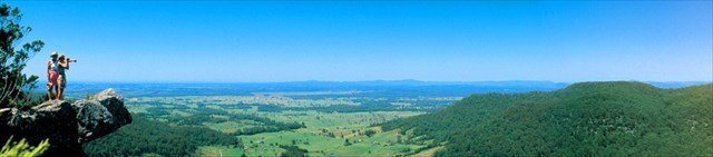
Located on the mid-north coast of New South Wales, between the towns of Coopernook and Wauchope, the Lorne Basin is a nearly circular bowl-shaped formation 35 kilometres in diameter, with Triassic sedimentary rocks (in excess of 200 metres thick) of similar age to those of the much larger Sydney Basin.
The basin floor is composed of Palaeozoic rocks (250 to 550 million years ago) of New England Orogen overlain by Triassic terrestrial sedimentary rocks (from 210 to 240 million years ago). These sedimentary rocks have been intruded by Late Triassic to Early Jurassic (around 200 million years ago) igneous rocks and later by Tertiary igneous rocks (2 to 65 million years ago). Faulting has disturbed the Palaeozoic and Mesozoic sedimentary sequence and the basin floor now has an overall dip of about 4° to the east.
The Lorne Basin is unusual in that it has two circular uplifts. Circular uplifts centred within a circular basin are suggestive of the central uplift zone of a large impact crater. A possible impact origin for the Lorne Basin was first suggested, on the basis of other criteria, by Tonkin (1998). The structure may have been created by a meteor impact some 250 million years ago in the Triassic period. As well as its circular morphology, the presence of glass containing metallic iron and nickel, and Granitoid intrusions is all evidence for the Lorne Basin being the site of impact origin. Meteor impact sites are uncommon; approximately 180 terrestrial impact sites have been confirmed globally. These sites provide us with information about the creation and shaping of our planet and the solar system. Research into the role of impact events in mass extinctions (such as that of the dinosaurs) is on-going, although much of the available literature suggests a strong correlation between the two. The Lorne Basin meteor impact structure (if confirmed) would be the only known impact site in NSW with a degree of surface expression and in this regard would be of state significance. Investigations continue.
The Triassic sediments of the Lorne Basin were deposited by processes associated with rivers and streams. During the Triassic Period, structural movement caused the basement to be uplifted into the Early Triassic rocks to form the circular Black Creek Uplifts and Holey Flat Uplift (the circular uplifts mentioned above). These structures influenced the emplacement of Late Triassic to Early Jurassic igneous intrusions.
Weathering has removed the Triassic cover over the remainder of the Black Creek Uplift but its location is marked by two concentric lineaments about 300m to 400m apart. Their specific location is usually indicated topographically by gullies or saddles in the ridges. Both of these structures predate emplacement of the Brothers intrusions. Late Triassic - Early Jurassic igneous rocks of the South Brother Mountain overlie the eastern rim of the Holey Flat Uplift.
Around Lorne and Milligans Road (just south of Wauchope) there are the deposits of the Milligans Road Formation, composed of sandstone, airfall tuff (consolidated volcanic ash) and minor carbonaceous mudstone. While no identifiable fossil plants have been recovered to confirm age, the airfall tuffs are believed to be associated with the emplacement of Late Triassic to Early Jurassic felsic igneous rocks in the immediate vicinity i.e. North, Middle and South Brother Mountains.
Four faults splay from the Waitui Fault south of Stewarts River and appear to provide conduits for the Big Nellie, Small Nellie and Flat Nellie volcanic plugs which were formed in the Tertiary period after the Brother's intrusions.
Three prominent volcanic intrusions known as Big Nellie, Flat Nellie and Little Nellie composed of tertiary rhyolite, dominate the park. The summit of Big Nellie, which is marginally the highest plug, rises to 560 metres above sea level, Little Nellie has an elevation of 555m, and Flat Nellie 485m. The Nellies are pyroxene-rich trachyte plugs that are the remains of a Tertiary volcanic event where Triassic sediments including conglomerates and sandstones were subject to intrusion by hot, viscous, silica-rich lava.
Source and more information on this area and subject can be found at http://www.geomaps.com.au/scripts/lornebasin.php
Earth cache.
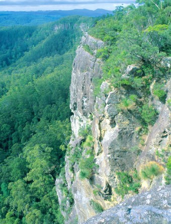
1. Looking along the exposed Heath on the right hand side of the lookout - you will see a large shear cliff.
1a - Can you see any vegetation growing out from this cliff?
1b - If you can see vegetation growing. How does it grow along this sheer cliff? How did the rock formation become available for this growth?
2. After learning that Big Nellie is a Volcanic peak. What is the scientific name of the rock that is formed?
3. The Volcanic rock is said to be from the Tertiary period. Approx how many years ago was this time?
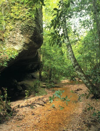
4. Feel free to post photos from the Lookout or the Cave area. (Optional)