Welcome to the 2019 Edition of Cache Across Maryland, hosted by the Maryland Geocaching Society. This is one of ten geocaches placed throughout the "Old Line State" in locations chosen to showcase Maryland's diverse beauty, history and terrain. From the mountains of Western Maryland to the Atlantic Ocean, Cache Across Maryland 2019 will again demonstrate that Maryland truly is “America in Miniature”.
Each of the ten geocaches contains a code which you will use to determine the location of the CAM 2019 Picnic to be held on May 4th, 2019. The code can be found on the inside of the cache container and on the inside front cover of the logbook. Don't forget to record this code! Any geocacher who has completed all TEN of the CAM geocaches and attends the CAM Picnic on May 4th will receive a Certificate of Completion and a Cache Across Maryland 2019 commemorative geocoin in antique copper. We hope you enjoy CAM 2019!
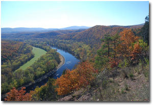
Green Ridge State Forest
 At 47,560 acres, Green Ridge State Forest is the largest contiguous block of public land in Maryland. Green Ridge is located within the Ridge and Valley Province of the Appalachian Mountains. It is rich in both natural and cultural heritage and remains a "working forest" today. It is managed by the Maryland Department of Natural Resources Forst Service to conserve the natural ecological processes while supporting the economy of the region through an active forest management program. The Maryland Forest Service mission is to restore, manage, and protect Maryland's frees, forests, and forested ecosystems to sustain our natural resources and connect people to the land.
The general geographic boundaries of Green Ridge are Town Creek to the west and Sideling Hill Creek to the east; the northern boundary extends to the Mason-Dixon Line; and the southern boundary parallels the Potomac River. Elevations range from 500 feet above sea level on the Potomac River to 2,000 feet on Town Hill. Green Ridge receives the least amount of rainfall in Maryland, averaging 36 inches annually.
In the early 1800s, Richard Caton and William Carroll, in partnership, owned much of the land that is Green Ridge State Forest today. Richard Caton was the son-in-law of Charles Carroll of Carrollton, a signer of the Declaration of Independence. William Carroll was the grandson of Daniel Carroll of Rock Creek, a framer of the United States Constitution. The land was originally patented from vacant lands during the 1820-1840 period for inclusion into various timber and mining interests, primarily the Town Hill Mining, Manufacturing and Timber Company. This business venture was financed by the estate of Charles Carroll of Carrollton. The crumbling stone structure known as the Carroll Chimney, part of the steam-powered sawmill built in 1836, is the only known surviving structure of that period.
In the 1880-1912 era, most of the remaining virgin forest was cut and a period of neglect resulted in numerous wildfires. During the easrly 1900s, the Mertens family of Cumberland attempted to convert the forest into apple orchards and promoted the area as "The Largest Apple Orchard in the Universe".
The orchard was subdivided into 10-acre parcels and sold to individuals as investment properties. Five acres of each parcel was cleared, burned, and planted with apple trees. The remaining five acres had the best trees cut and the poorer trees were left standing. The orchard company went into bankruptcy in 1918. The interests of the corporation were acquired by the State Department of Forestry in 1931.
The first forest management activities at Green Ridge were performed by the Civilian Conservation Corps (CCC) in the 1930s. Their main focus was fire control. Other work consisted of building roads, trails, recreation enhancements, and the management of existing forest for its future timber and wildlife potential.
During World War II, the CCC camp at Fifteen Mile Creek housed German prisoners of war who were required to cut pulpwood in the forest. As the forest grew it became popular with outdoor enthusiasts, especially hunters. It also contributed more and more to the local wood products industry.
Today, Green Ridge is a diverse forest consisting primarily of second-growth, 110-year old even-aged mixed oak forest, with mixed hardwood, bottomland hardwood, Virginia pine and mixed pine forests, in a wide variety of age classes resulting from various silviculture activities beginning in the late 1960s.
Park Regulations/Information:
- Please cache only during daylight hours.
- Forest Headquarters open 8am - 4pm daily.
- Primitive campsites available by permit only.
- Backcountry backpack camping is permitted.
- Regulated hunting available in season and with special restrictions.
- Fishing is available, with proper license only.
- See the Maryland DNR website for further information on permits, seasons, and restrictions.
- Pets are allowed. All animals must be leashed; clean up after your pets.
- No alcoholic beverages.
The Geocache
This geocache is located at the listed coordinates.
You can reach the parking coordinates from the well-maintained dirt road called 15 Mile Creek Southwest off of Interstate 68 at Exit 62. If the dirt road is not passable you can approach on pavement from Old Cumberland Road NE off of US Route 40.
Once at parking you can take the purple trail from the TH for a nice and scenic walk along the river (albeit at a higher terrain). For an easier but less scenic approach, follow the road to GZ.
If you have a handicap pass and the yellow pipe gate is unlocked you may be able to drive close to GZ. If the gate is locked you can still proceed to GZ on slightly better terrain by following the road.
As with any outdoor activity, geocaching has potential risks. It is your responsibility to determine those risks and make your own choices in pursuing a geocache. If at any time you are injured or need emergency assistance, dial 911.