If there is one type of rock most associated with the Yorkshire Dales then it is limestone and it is certainly limestone you will see when you come to visit Troller's Gill. Limestone was formed millions of years ago by the gradual build up of calcium-rich skeletons and the shells of billions of tropical sea-creatures. It is strange to think that when you are standing here, you are actually standing on the bed of what was once a tropical sea.
Classic Yorkshire limestone features include pavements and scars or crags. Here you are visiting a gill. There are many gills in Yorkshire but it perhaps isn't a term you hear all over the country. It is actually a Viking word so a gill is actually their word for a ravine, which is a narrow steep-sided valley. Troller's Gill is actually believed to have come from old norse, or Viking, so the full translation is actually 'The Troll’s Arse Ravine' which I'm sure you agree sounds attractive - I imagine there won't be any hurry to update to the full English translation.
Trollers Gill is dry for most of the year as the beck goes underground and appears again in springs at the foot of the ravine. After heavy rain the stream bed can quickly fill up making the passage up our down the ravine quite tricky. After a sustained period of rain it can be impassable so you might want to avoid visiting when there has been notable rain.
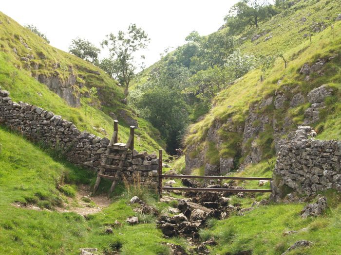
Trollers Gill is a hidden gem that some feel is a worthy rival to the larger Gordale Scar. It isn't as big but it's very atmospheric and very beautiful and the relative lack of visitors makes it more enjoyable. For lovers of geology and limestone you cannot leave disappointed, there's so much to see. There's a permitted path through it and the land is open access.
The EarthCache takes you to one particular place where we want to examine some river erosion. It is very obvious Troller's Gill is only here as a result of the stream eroding the limestone over the years. But how exactly has the water formed the gill - and in particular, how has it formed what you see when you arrive at the listed coordinates?
And finally - this place is full of legends. We've already identified that the Vikings associated trolls with the place, however the ravine is also the legendary home of a barguest, a black spectral hound with large eyes that can turn people to stone. There are also claims Trollers Gill is home to boggarts, imps and pixies. So whilst looking for the geological facts, keep an eye out just in case!
Please follow the paths around to the top or bottom of the gill, don't try and cut across directly to the coordinates as you'll have to climb down the cliff!
Sedimentary Rocks
Limestone is a sedimentary rock. Sedimentary rocks can be formed from particles of sand, shells, pebbles, and other fragments of material. Together, all these particles are called sediment. Gradually, the sediment accumulates in layers and over a long period of time hardens into rock. An example might be millions of years ago a flood caused a layer of sand to be deposited. Then maybe a few years or many years later another flood left another layer of sand. This process continued for millions of years, the lower layers gradually getting squeezed more and more by the heavy deposits above them.
River Erosion
Erosion is the breaking down of material by an agent. In the case of a river, that agent is water. The water can erode the river’s channel and the river’s load. A river’s load is bits of eroded material, generally rocks that the river transports until it deposits its load.
A river’s channel is eroded laterally and vertically making the channel wider and deeper. The intensity of lateral and vertical erosion is dictated by the stage in the river’s course - essentially, in the upper stage of the river’s course (close to the source of the river) there is little horizontal erosion and lots of vertical erosion. In the middle and lower stages vertical erosion is reduced and more horizontal erosion takes place.
Types of River Erosion
There are four key types of erosion that take place in rivers and these are outlined below.

Hydraulic action
The pressure of water breaks away rock particles from the river bed and banks. The force of the water hits river banks, and then pushes water into cracks. Air becomes compressed, pressure increases and the riverbank may, in time collapse. Where velocity is high e.g. the outer bend of meaner, hydraulic action can remove material from the banks which may lead to undercutting and and river bank collapse. Near waterfalls and and rapids, the force may be strong enough to work on lines of weakness in joints and bedding planes until they are eroded.
Abrasion / Corrasion
The sediment carried by a river scours the bed and banks. Where depressions exist in the channel floor the river can cause pebbles to spin around and turn hollows into potholes.
Attrition
Eroded rocks collide and break into smaller fragments. The edges of these rocks become smoother and more rounded. Attrition makes the particles of rock smaller. It does not erode the bed and bank. Pieces of river sediment become smaller and more rounded as they move downstream.
Corrosion / Solution
Carbon dioxide dissolves in the river to form a weak acid. This dissolves rock by chemical processes. This process is common where carbonate rocks such as limestone and chalk are evident in a channel.
Questions to Answer (Logging Requirements)
I've made it a D3 because there are a few questions - but although there's a few, I've made the questions really easy by splitting everything down so many of the questions only need a couple of words to answer and all the information can be found in the listing. Sometimes it's easier to ask more questions with simpler answers than to ask less questions with more complicated answers so please give it a go, I'm sure you'll have no problems. It is a T4 as the stream may flow at times, the terrain is easier when it isn't but the ground is rough and slippy at all times as you are essentially walking on a stream bed.
There is no physical box here, in order to log a find on an EarthCache you must answer the questions below and send them to me via my profile (either email or message centre). I do read all answers and try to reply to them all - however if I'm busy I may not be able to reply immediately so please do not wait for a reply before posting your find. You are not expected to have any previous geological knowledge, your best attempt at the answers is all that is required. Ideally, please send your answers at the same time you submit your log, or within a few days of your visit. If you do not send answers, your log may be deleted.
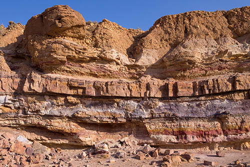
When you arrive at the listed coordinates you are stood in a valley which is here entirely due to river erosion. However, in front of you there is a cliff and the bottom of this cliff has itself been significantly eroded making quite a spectacular sight - you could almost say a cave has been cut into the bottom of the cliff. For the following questions, this is the area I would like you to look at.
Q1 - Firstly, what is it about the direction/path of the water flow that has caused erosion on this side rather than the other side?
Q2 - Given the water has always taken the same direction/path, and thinking about the way this limestone has been formed, why do you think this area at the bottom of the cliff has eroded so much more than the cliff higher up or lower down?
Q3 - Which two of the 4 erosion processes outlined in the lesson do you think are the main causes of the erosion here?
Now take a walk down Troller's Gill to deepest part of the main ravine. It is impressive how quickly the gorge deepens.
Q4 - How high do you estimate the top of the cliff to be from your feet?
Q5 - How far are you from the listed coordinates?
Remain in the deep ravine. For the final question you need to give some through to how this ravine must have formed. Look at the hill, the cliffs above you and think again about the erosion processes in the listing.
Q6 - Does the stream take a straight route through the hillside? Why do you think this might be?
Q7 - Which of the erosion processes outlined are responsible for creating the main ravine - are they the same or different to those you identified earlier?
Q8 - If the stream is currently flowing beneath you, what could potentially happen in the future?
Optionally, please include a photo from anywhere in Troller's Gill as additional proof of your visit, but please don't include the feature mentioned in the first few questions. Thanks.
Thank you for visiting Troller's Gill