Moongalba
Welcome to Moongalba (Myora Springs) on Minjerribah (North Stradbroke Island.)
History
The Quandamooka people (‘people of the bay’) have lived on Minjerribah (‘place of many mosquitoes’) for at least 25,000 years. Moongalba is a place of significant cultural significance to the Quandamooka people, the food rich surrounding land and waters making this location a favoured campsite.
North Stradbroke Island Geology
North Stradbroke Island is the second largest sand island in the world, the largest being Fraser Island. North Stradbroke Island is almost entirely comprised of ancient overlapping sand dunes laid down over bedrock. Bedrock outcrops of rhyolite at Point lookout and Mesozoic sandstone at Dunwich have helped anchor these sand dunes.
The sand in these dunes originated from weathered sedimentary rocks and granite in the mountain ranges in northern NSW. These eroded sediments were transported by rivers to the coast and then picked up by coastal currents before ultimately being deposited on Minjerribah, where winds deposited the sands and built the dunes. The age of sand dunes varies from mid Pleistocene (approximately 300,000 years ago) to recent.
Groundwater Aquifer
Rain falling on North Stradbroke Island recharges a massive aquifer of groundwater, estimated at between 800 and 1300 Giga litres or approximately 1.6 to 2.6 times the volume of Sydney Harbour. This aquifer forms a “central mound” or lens of freshwater in the permeable sand that forms the island.
Since the commencement of groundwater observations in 1965, the maximum observed height of the groundwater mound was 44 metres above mean sea level in 1975, and minimum observed height of 34 metres above mean sea level occurred in 2007. The depth of the groundwater varies from 180 m deep near Mt Hargreave (elevation 219m) to 0 m deep at coastal swamps and springs. Pressure within this massive aquifer prevents saltwater intrusion into the aquifer from the sea and drives groundwater out beyond the coastline.
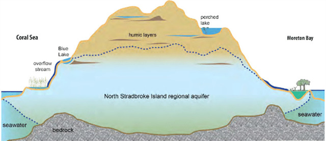
Discharge (estimated at around 130 Giga litres per annum) from the aquifer occurs via groundwater extraction for the Redland Community and sand mining activities as well as groundwater flow into coastal wetlands and swamps, Blue Lake, through evapo-transpiration, submarine discharge and flow into various springs and creeks. One such ground water release point is Myora Springs.
Logging this Earthcache
Waypoint 1
At Waypoint 1, observe the water flowing through the pipe.
Q1. Approximately how many litres per day discharge from the aquifer at Myora Springs?
Waypoint 2
Some of the creekside landscape is manmade, albeit over a long period of time. At Waypoint 2 look across Capembah Creek.
Q2. Describe how the man made mound on the opposite bank was formed.
Q3. Over what period of time did this occur?
Waypoint 3
Q4. At waypoint 3, describe the topography surrounding the springs.
Q5. Why would you expect to find a spring at a location with this topography?
Feel free to log your cache as found after your visit. However, you must send your answers by email or the geocaching message service to me within a reasonable time of logging the cache. I will contact you with any queries or concerns I have about your answers.
References
Leach, LM. Hydrology and physical setting of North Stradbroke Island - Proceedings of the Royal Society of Queensland, Vol. 117, 2011: 21-46. Availability: ISSN: 0080-469X. [cited 30 Dec 18]
A nature guide to North Stradbroke Island – Minjerribah; Barram, & Crew S; Friends of North Stradbroke Island, 2016