The spectacular cliffs at Hartland Quay with their incredibly contorted rock layers do not need any kind of geological knowledge to appreciate how spectacular they look. In addition, at low tide there is plenty of sand, rock pools and rocks to scramble over whilst in wild weather it is the perfect place to appreciate the power of the sea and wind as the waves crash against the cliffs and shore.
Please note, to complete this EarthCache you will need to consider the tide times as it is not accessible at high tide. The feature you need to visit is close to the cliffs so can be visited most of the time, but it will be inaccessible at high tide and immediately around those times so do check. You do need to cross some angled rocks to reach GZ but it shouldn't be too tricky for most.
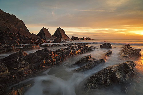
So what is it that makes this place so impressive from a geological point of view? Well, the cliffs all along the Peninsula here consist of some of the most dramatic folded and compressed rocks you will see with Hartland Quay a particular highlight. In reality, the rocks of Hartland Quay are the remains of a mountain range and the cliffs here are famous because they have the power to inspire both non-specialists and the professional geologist but little or no geological knowledge is required to appreciate the hundreds of millions of years of natural history, nor hopefully will you find you need any to complete this EarthCache.
Sedimentary rocks will be found here...
It should be fairly obvious when you arrive here to see the rock is in very well defined layers and this means they are sedimentary. Sedimentary rocks can be formed from particles of sand, shells, pebbles, and other fragments of material. Together, all these particles are called sediment. Gradually, the sediment accumulates in layers and over a long period of time hardens into rock. An example might be millions of years ago a flood caused a layer of sand to be deposited. This might create one layer of the rock you see here. Then maybe a few years or many years later another flood left another layer of sand. Again, another layer is created. This process continued for millions of years, the lower layers gradually getting squeezed more and more by the heavy deposits above them. The thickness of the layer is determined by the amount of sediment deposited, therefore a bigger and longer flood would deposit more sediment creating a thicker layer.
As you can probably imagine, if these rocks were formed by sediment left by water, the rocks when formed would have been flat - or horizontal on the ground. Any rocks you see at Hartland Quay that are not flat or horizontal on the ground have been moved later by geological processes and how this has happened is explained below. But even without considering the angle the rocks are at, Hartland Quay is a superb place to see sedimentary rocks and the layers are extremely clear to see in the best and most spectacular form.
The sedimentary rocks you see before you here were deposited in a shallow sea during the Carboniferous period – about 320 million years ago. The layers are sequences of shales and mudstones representing the remains of sub-marine “avalanches” of sediments called turbidites. At the same time as the sands and mudstones were being deposited at Hartland, coals were being deposited in swamps, forming the South Wales coalfields.
Sedimentary rock is not always consistent and because the rock here at Mouthmill Beach has been formed of shales and mudstones there is a variation in strength. As explained above, each layer is formed at a different time and from a different 'batch' of sediment. This means some layers may be strong whilst some are more weak and therefore more susceptible to erosion forces many years later.
Why do the rocks now look like a giant has been folding them up?
Well, it wasn't a giant, let's be honest. They don't tend to feature in the geological papers. EarthCaches about folded rocks can be tricky to understand but don't be reaching for your paracetamol just yet as I'm going to try and make this as clear as the water splashing about in the sea nearby (which looks lovely by the way).
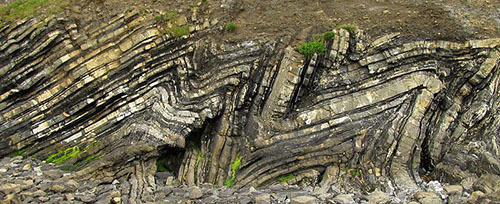
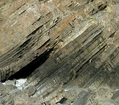
Folded rocks pictured elsewhere
Firstly, imagine that the ground you walk on, also known geologically as the Earth's outer shell, is divided into several plates that glide over the mantle (the mantle is the rocky inner layer above the Earth's core). Now, imagine that those plates once created super continents - and then imagine that those two plates/super continents collided. There's no great speeds involved, the movement is extremely slow but imagine the weight and force they would have. Now that you have got the image of these two plates colliding in your mind, picture Hartland Quay being right in the middle. It's similar to a car crash when all the metal bends and gets compressed - the same happened here to our sedimentary rock and at the time it pushed the rock upwards creating a mountain range, hard as that might be to believe now.

So hopefully that has explained why the layers of rock here are a little bent looking. Devon was at the southern margin of a super-continent called Laurasia, which collided with the super-continent Pangaea – to the South. As these two mega-continents collided during the Variscan Orogeny the rocks at Hartland Quay were buckled and folded, producing the spectacular folds exposed in the cliffs today. The top surface was then later eroded flat which is probably as well or the land would be very different to what it is today, it would have been a more mountain-like atmosphere but we won't go into how that happened!
Measuring the Dip Angle
Where the sedimentary rock layers are no longer flat/horizontal it is quite interesting to measure the dip angle of the rock layer as it demonstrates how much they have been lifted from their original horizontal position. This could be done by estimation but it is much better if you use a tool to obtain a proper reading. Geologists use clinometers and actually it is quite easy to make your own, you can look this up on the world wide web and prepare one before you come. In this more modern age, smartphones have the ability to accurately measure the dip angle and you can download free apps to do this on all types of smartphone.
Looking at Folds in more detail
The geology of folds is very complex, we often look at anticlines and synclines but in cliffs that are as distorted as those here is becomes hard for someone who isn't an expert to be able to identify exactly what they are looking at. Therefore, to keep it understandable here we are only going to consider the types of fold that have occurred here. The diagram below will help to explain the main types of fold that can occur.

- If the two limbs of the fold dip away from the axis with the same angle, the fold is said to be a symmetrical fold.
- If the limbs dip at different angles, the folds are said to be asymmetrical folds.
- If the compressional stresses that cause the folding are intense, the fold can close up and have limbs that are parallel to each other. Such a fold is called an isoclinal fold (iso means same, and cline means angle, so isoclinal means the limbs have the same angle). Note the isoclinal fold depicted in the diagram above is also a symmetrical fold.
- If the folding is so intense that the strata on one limb of the fold becomes nearly upside down, the fold is called an overturned fold.
- An overturned fold with an axial plane that is nearly horizontal is called a recumbant fold.
- A fold that has no curvature in its hinge and straight-sided limbs that form a zigzag pattern is called a chevron fold.
Logging Requirements (Questions to Answer)
The given coordinates bring you to a particular sedimentary rock feature that is quite dramatic. It has been partly formed by erosion but we are not looking at that here as I have a sister EarthCache to this one just a few miles up the coast at Blackchurch Rock which considers the coastal erosional processes. For the purpose of this EarthCache we are interested the sedimentary rocks that form the feature here and the folds you can see in the cliffs all around you. The questions all relate directly to the information provided in the listing so you should be able to answer everything from GZ with no extra reading required. Please ensure you send in the answers at the time or soon after you log your find as logs may be deleted if no attempt at the answers are made.
Questions 1-3 relate to the obvious geological feature you find at the given coordinates. This is a superb example of tilted sedimentary rock with no visible folds.
Q1 - Standing in the hole, how many layers of rock are above you (to the nearest 10)?
Q2 - What is the dip angle of the rock layers here? (Ideally use smartphone app/clinometer)
Q3 - Does the thickness in the layers vary? What is the approximate size of the thickest/thinnest layers? Why do they vary?
Q4 - Look at the material the layers are made from. Does the eroded layer look like it is made from the same material as the remaining layers or does it look different? Do you think there is a reason why this layer may have eroded before the others?
Questions 5-6 relate to the main cliff face making up the Hartland Quay bay, easily visible to the north-east of the given coordinates. There is no need to go any nearer to the cliffs.
Q5 - From the list outlined previously, which is the most prominent type of fold visible in these cliffs?
Q6 - Can you identify any other types of fold in the cliff?
Optionally, a photograph of you or your GPSr in the middle of the feature at the given coordinates would be good additional proof of your visit.
Thank you for visiting Hartland Quay