
Flujo de Lava
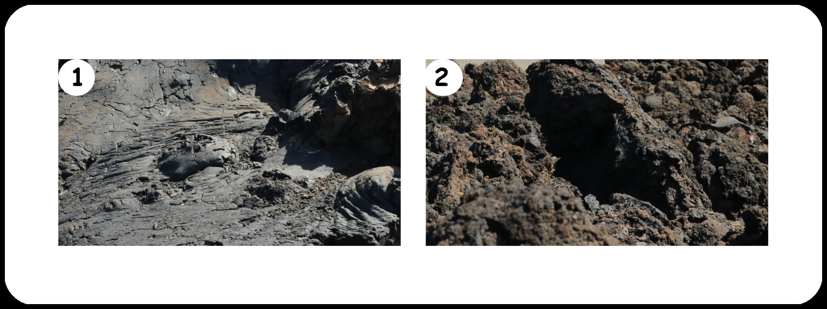
Dado que las Islas Canarias son de origen volcánico, claro que se encuentran rocas volcánicas de diferentes formas y tamaños a cada paso. Hay piedras pómez ligeras, campos de ceniza negra y flujos de lava solidificados con superficies rugosas o lisas, dependiendo de la temperatura y la viscosidad del flujo de lava. La lava se divide a grandes rasgos según los nombres elegidos por los aborígenes de Hawaii en lava pahoehoe (1), que puede traducirse aproximadamente como lava descalza, y lava ʻAʻā (2), que significa áspera y dolorosa.
Aquí usted puede encontrar un bonito pedazo de un flujo de lava que debes investigar para registrar este Earthcache. Por favor, responde a las siguientes preguntas:
.
- 1) ¿Qué tipo de lava encuentras aquí?
- 2) ¿Cuántos metros puedes caminar por la parte intacta?
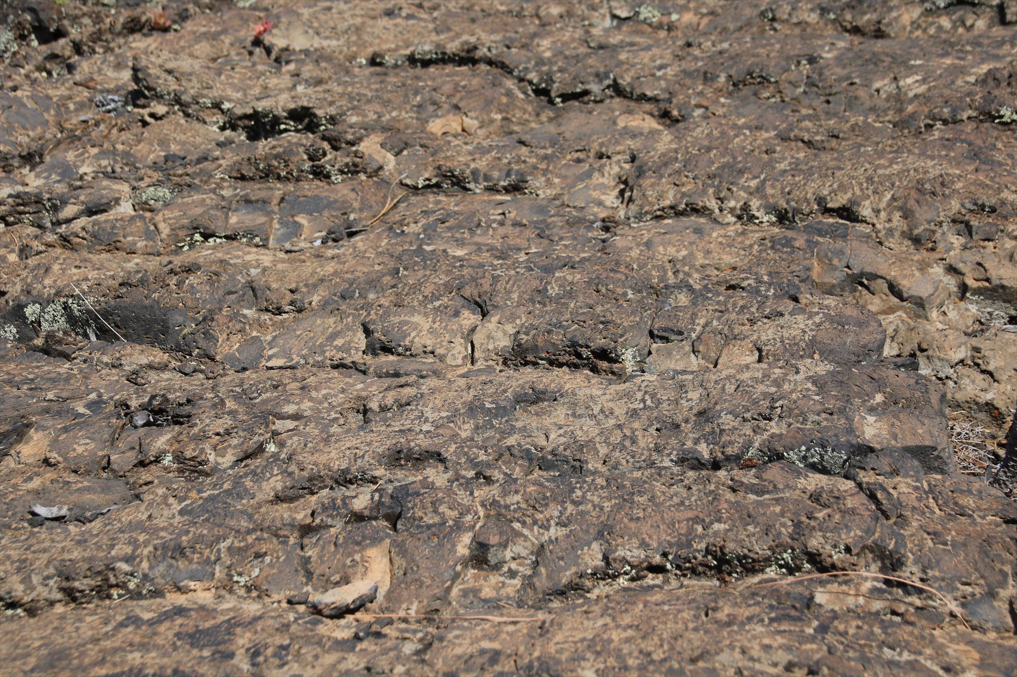
- 3) Cuando vuelvas a la ruta, podrás ver fácilmente las capas (vease imagen abajo) que se han solidificado aquí. ¿Cuántas capas cuentas desde la gran grieta hasta el camino? (No tiene ser exacto.)
- 4) ¿Qué crees, es esto el techo de un tubo de lava? Justifiqua tu opinión.
- 5) Sube una fotografía tuya y / o del tuyo GPS con lava detraz.
Envía tus respuestas (en español, inglés o alemán, por favor) por correo a flinxinflux@web.de o utiliza el centro messages. Puedes registrar tu visita inmediatamente. No tienes que esperar la nuestra respuesta. Te vamos contactar en caso que haya problemas.
---------------------

Lava Flow
Since the Canary Islands are of volcanic origin, you will of course encounter volcanic rocks of various shapes and sizes at every turn.
There are light pumice stones, fields of black ashes and solidified lava flows with rough or smooth surfaces, depending on temperature and viscosity in the lava flow. The lava is broadly divided according to the names chosen by the aborigines of Hawaii into pahoehoe lava (1), which can be translated as barefoot lava, and ʻAʻā lava (2), which means rough and painful.
Here you will find a nice piece of a lava flow you should examine to log this Earthcache. Please answer the following questions:
- 1) What kind of lava is this?
- 2) How many meters can you walk along / on the intact part?
- 3) When you return to the path, you can easily see the layers (see picture below) that have solidified here. How many layers do you count from the big crack to the path? (Doesn't have to be exact.)
- 4) What do you think, is this the roof of a lava tube? Justify your opinion.
- 5) Add a photo of you and / or your GPS.
Send your answers (please in German, English or Spanish) as mail to flinxinflux@web.de or use the message center.
You may log your visit immediately. You don't have to wait for our answer. In case of problems we will contact you.
---------------------

Lava-Strom
Da die Kanaren vulkanischen Ursprungs sind, begegnet man hier natürlich auf Schritt und Tritt Vulkagestein in verschiedener Ausprägung.
Man findet leichte helle Bimssteine, schwarze Aschefelder und erstarrte Lavaströme mit rauhen oder glatten Oberflächen, je nach Temperatur und damit Viskosität im Lavastrom. Die Lava teilt man grob nach den auf Hawaii von den Ureinwohnern gewählten Bezeichnungen ein in Pahoehoe-Lava (1), was in etwa mit Barfuß-Lava übersetzt werden kann, und ʻAʻā-Lava (2), was rauh und schmerzhaft bedeutet.
Hier findest Du ein gut zu betrachtendes Stück eines Lavastroms, das Du untersuchen sollst, um diesen Earthcache zu loggen. Beantworte bitte folgende Fragen:
- 1) Um welche Art von Lava handelt es sich hier?
- 2) Wieviele Meter kannst Du an/auf dem intakten Stück entlanggehen?
- 3) Wenn Du wieder zum Weg zurückkehrst, kannst Du gut die Schichten (siehe Bild unten) erkennen, die hier erstarrt sind. Wieviele Schichten zählst Du vom großen Riss bis zum Weg? (Muss nicht ganz genau sein.)
- 4) Was denkst Du, handelt es sich hier um das Dach einer Lavaröhre? Begründe Deine Meinung.
- 5) Füge ein Foto von Dir und / oder Deinem GPS an Dein Log an.
Sende Deine Antworten (bitte auf Deutsch, Englisch oder Spanisch) als mail an flinxinflux@web.de oder verwende das Message Center.
Du kannst dann unmittelbar Deinen Besuch loggen, ohne auf eine Antwort von uns zu warten. Sollte es Unstimmigkeiten geben, melden wir uns.
Capas - Layers - Schichten:
Fuentes:/Sources:/Quellen:
[1] Wikipedia®
[2] Fahnen und Flaggen von Nationalflaggen.de
[3] Traducción realizada con el traductor/Translated with/Übersetzt mit Unterstützung von DeepL: https://www.deepl.com/translator