Sedimentary rocks can be lifted, folded or even bent creating really eye catching shapes and here on the beach next to Bude Breakwater is a superb and accessible (when the tide is out) example of a rock that is anything but flat - the shape has given it the local name of the Whales Back. There is a sister EarthCache closeby looking at erosion/weathering so please take the opportunity to complete both - they look at very different geology which is why they are two different EarthCaches.
This EarthCache is designed to be completed in the field. There is a little information to read through but it is specially written for the EarthCache so it is easy to understand - you absolutely do not need any previous geological knowledge. The questions will then be really easy to answer as they directly relate to the information in the listing and no further reading or research is required. Therefore if you have the time you can easily complete the whole thing and send in answers from GZ. It really is all very simple. Please do note that the rock is tidal so please ensure you visit when the tide is low as the EarthCache cannot be completed without visiting the rock.
Sedimentary rocks will be found here...
It should be fairly obvious when you arrive here to see the rock is in well defined layers and this means it is a sedimentary rock. Sedimentary rocks can be formed from particles of sand, shells, pebbles, and other fragments of material. Together, all these particles are called sediment. Gradually, the sediment accumulates in layers and over a long period of time hardens into rock. An example might be millions of years ago a flood caused a layer of sand to be deposited. This might create one layer of the rock you see here. Then maybe a few years or many years later another flood left another layer of sand. Again, another layer is created. This process continued for millions of years, the lower layers gradually getting squeezed more and more by the heavy deposits above them. The thickness of the layer is determined by the amount of sediment deposited, therefore a bigger and longer flood would deposit more sediment creating a thicker layer.
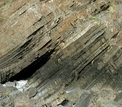
The sedimentary rocks you see before you here were formed when sand and mud layers were deposited in a giant tropical “Lake Bude” 300 million years ago. What you see here today at GZ are exposed alternating beds of sandstone and dark shale.
As you can probably imagine, if these rocks were formed by sediment left at the bottom of a lake, the rocks when formed would have been flat - or horizontal on the ground. As this is no longer flat it means it must have been changed by some kind of geological process. We will look at this process in the next section.
Bude sandstone is grey thick-bedded sedimentary rock composed mostly of quartz sand. Where many sandstones have feldspar as a major component, here at Bude it is clay and silt. It has discontinuous internally massive beds that are 1-5m thick and these have amalgamated into units up to 10m thick. Sandstone is a type of rock that forms when grains of sand are compacted together over significant periods of time so it often has a sandy texture but the grains can vary in size and could be extremely small.
Shale is a specific type of mudrock found here. Shale is a fine-grained, sedimentary rock composed of mud that is a mix of flakes of clay minerals and tiny fragments (silt-sized particles) of other minerals, especially quartz and calcite. The ratio of clay to other minerals is variable. With increased pressure over time, the clay minerals may become aligned, with the appearance of parallel layering. This finely bedded material splits readily into thin layers and is called shale, and this is the distinction from mudstone. Shale is characterized parallel layering or bedding less than one centimeter in thickness. This makes it look like it has many thin sheets and this is what makes it different to other mudstones.
Sedimentary rocks involved in an accident...
It happens every day. Two cars collide and all the metal gets bent into different shapes. Some bends into curves, other bits get sharp folds depending on the pressures of the crash. Well, the same thing happens with the Earth's rocks. You get two continents just gliding along without looking where they going and suddenly they collide - imagine what would have to happen to the rock right on the edge where the impact has happened.
Now you have that image in your mind, lets add in some geology. The ground you walk on is known geologically as the Earth's outer shell and is divided into several plates that glide over the mantle (the mantle is the rocky inner layer above the Earth's core). Now, imagine that those plates once created super continents - and then imagine that those two plates/super continents collided. There's no great speeds involved, the movement is extremely slow but imagine the weight and force they would have. Now that you have got the image of these two plates colliding in your mind, picture Bude being very close to the impact.
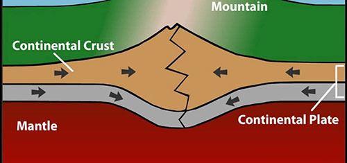
That is the simple reason why this rock before you is the shape you see (it also explains why the rocks in the cliffs all around Bude also look a little folded and bent). Devon was at the southern margin of a super-continent called Laurasia, which collided with the super-continent Pangaea – to the South. As these two mega-continents collided during the Variscan Orogeny the rocks at Bude were buckled and folded. The top surface was then later eroded flat which is probably as well or the land would be very different to what it is today, it would have been a more mountain-like atmosphere but we won't go into how that happened.
Anticlines and Syclines
Anticlines and Syclines are formed during the 'collision'. When the rocks collide there is much pressure - imagine the weight that is in an entire continent of the Earth and as it collides the outer edge has to take all the impact. Even in the shallow crust where rocks are cool and relatively brittle, folding can occur if the stress is slow and steady and gives the rock enough time to gradually bend. If the stress is applied too quickly, rocks in the shallow crust will behave as brittle solids and break. Deeper in the crust, where the rocks are more ductile, folding happens more readily, even when the stress and strain occurs rapidly. - it bent and when rocks bend they often form anticlines and syclines.

The rock you see here clearly did not break, it bent creating folds. The most basic types of folds are anticlines and synclines. Imagine a rug, the sides of which have been pushed toward each other forming ridges and valleys – the ridges are “up” folds and the valleys are “down” folds. In terms of geologic structures, the up folds are called anticlines and the down folds are called synclines.
To be a little more specific, an anticline is a fold that is convex up and has its oldest beds at its core, or the middle of the fold. A syncline is a fold with younger layers closer to the outer edge of the fold. You can remember the difference by noting that anticlines form an “A” shape, and synclines form the bottom of an “S.”
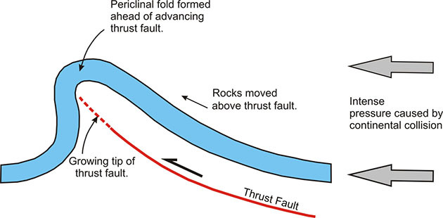
Periclines
In special circumstances, an anticline or a sycline can also be a pericline. They are a little more unusual and it's quite good if you find one. Most people would expect an anticline or sycline to be quite smooth as the diagram above demonstrates and you might have a similar dip angle on both sides. A pericline fold would have steeply dipping or overturned beds on one side and more gently dipping beds on the other side and this would need to be the case at both ends of the feature to be classed as a pericline fold. Periclinal folds are a type of anticline or syncline that have a well-defined, but curved hinge line and are doubly plunging and thus elongate domes.
Measuring the Dip Angle
Where the sedimentary rock layers are no longer flat/horizontal it is quite interesting to measure the dip angle of the rock layer as it tells you a lot about the rock. It is particularly useful to find out if a anticline/syncline is also a pericline. This could be done by estimation but it is much better if you use a tool to obtain a proper reading. Geologists use clinometers and actually it is quite easy to make your own, you can look this up on the world wide web and prepare one before you come. In this more modern age, smartphones have the ability to accurately measure the dip angle and you can download free apps to do this on all types of smartphone. You will enjoy the EarthCache much more if you are able to accurately measure the dip angles here but you can make estimations if you prefer.
Logging Requirements (Questions to Answer)
The given coordinates bring you to the Whale Back Rock. This is intended to be a simple and fun EarthCache - although there is a bit of information to read, it is easily achievable by anyone with no previous geological knowledge required as everything you need is in the listing. Being in a busy tourist place it aims to be good for beginners - if you've never done an EarthCache before please give it a go! You only need to read the information and use your eyes. Then send me your best attempt at the answers - I only ask that you give it a good try. However if you log without sending any answers, you risk your log being deleted.
Firstly, let's look at the sedimentary layers. You should be standing at the listed coordinates which allow you to view the Whale Rock - you should be facing the sea with your back to the breakwater (so you are looking at the end least eroded and best preserved).
1) The 'whale' has a thick skin (e.g. the top outer layer) - estimate the width of the skin, and please briefly describe it. Consider textures, shapes and colours.
2) Now look to the inner layers of the 'whale'. Briefly describe them - focus particularly on differences to what you described in question 1.
3) We know the Whales Back is formed from sandstone and shale layers. Identify which bits of the rock you think are sandstone and which bits are shale.
Now let's look at the shape of the rock and how it was changed when the continents collided long ago.
4) Is the rock an anticline or a sycline?
5) Please walk around the rock and measure the dip angle firstly on the two corners on the landward side, and then on the two corners on the seaward side of the rock (use your judgement where it has eroded). Using a free smartphone app or homemade clinometer is preferred but you can estimate.
6) Based on the information gained in question 5, do you think this is a pericline fold or not? Briefly explain why.
Please feel free to include a photo of yourself or GPSr with any of the features as additional proof of your visit, however try and avoid including any excessive spoilers if possible. Thank you.
Thank you for visiting the Bude Breakwater: The Whales Back EarthCache