A4-TMPT QUADRANT BEARINGS
ABOUT THIS CACHE:
This cache is part of the TRIANGLE MAN PUZZLE TRAIL (TMPT). You can read more about this trail after the section on this specific cache.
The theme for the Triangle Man’s arms (the “A” series caches) will be: Arms, Armor, Armory, Armies, and other such Militaria, etc.
As with all Puzzle Caches the container is not hidden at the above listed coordinates. You must determine the actual coordinates by solving the puzzle.
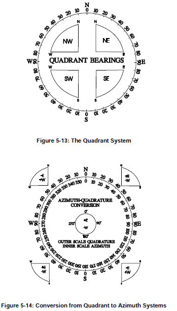
QUADRANT BEARINGS
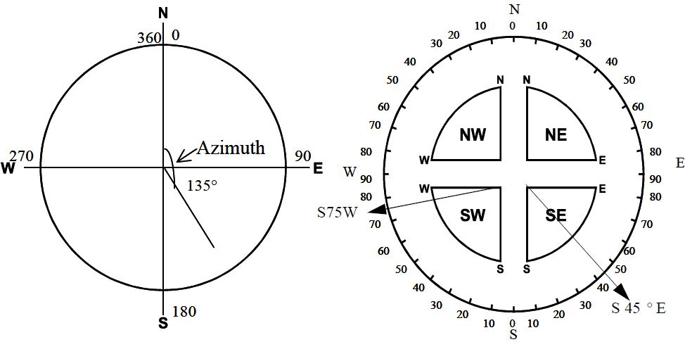
This geocache is about an important navigational skill, which is used by the military, search and rescue teams, navigators, and civilians alike to determine the direction to a given location.
If you do not already know how to take a quadrant bearing, I encourage you to do a little internet research on the topic. Here is a good starting place:
Quadrant Bearings vs Azimuths
It is an easy concept to understand and implement. While not exactly necessary for finding this cache, I hope that you will use this skill, along with a real compass (or the one on your GPS or Geocaching Ap) in finding the direction to this geocache’s log container.
RANGER BEADS

Ranger Beads are a tool used by the United States Army Rangers, and other land navigators to keep up with how far they have hiked. They are easy and cheap to make with para-cord and plastic beads.
They can be used equally well for keeping up with how many meters and kilometers you have hiked, or how many feet and miles you have hiked. While not exactly necessary for finding this cache, I hope that you will make yourself a set of Ranger Beads and use them to determine when you have reached this geocache’s log container. Here are some links which will help you:
How To Make Ranger Beads
Using Ranger Beads
WHERE TO START
Go to N 32 24.272 W 089 42.015
That is where to must be standing when you take your bearing and begin walking
WHICH DIRECTION TO WALK AND HOW FAR TO GO
The location of the container you seek, from the place where you start, is South 2.965 degrees West, 595.052 feet.
ABOUT THE TRIANGLE MAN PUZZLE TRAIL (TMPT):
The Triangle Man Puzzle Trail is a series of 100 Mystery/Puzzle Caches hidden in Scott County, Mississippi.
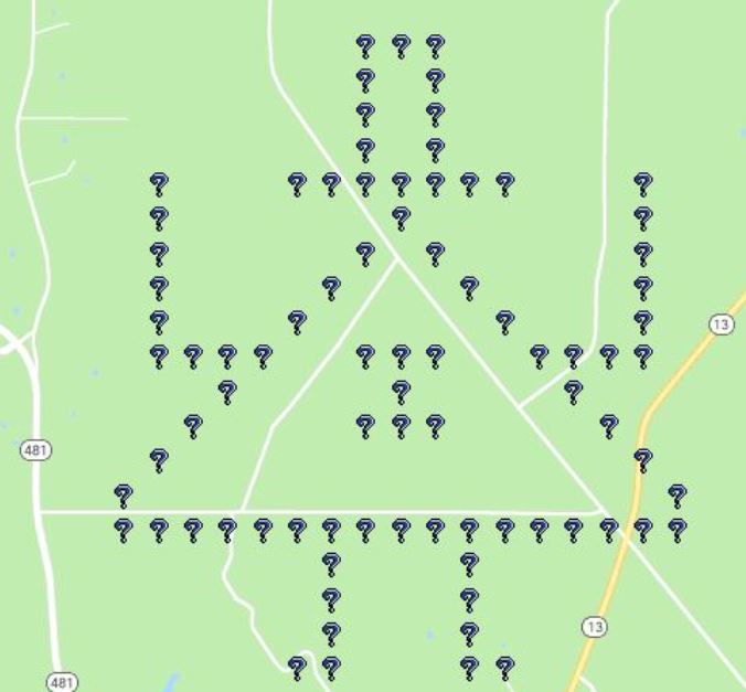
They are divided into six categories. Five of the categories make up the visible parts of the TRIANGLE MAN geoart which can be see on the geocaching.com map. (Actually, the full geo-art will not be visible on the map until I finish hiding all of the individual caches in this series. So until that is done, I have posted below an image for you of what it will look like.) The sixth category is an invisible mystery to be solved after all of the others.
 TRIANGLE MAN PUZZLE TRAIL CATEGORIES:
1. HAT: 16 caches (H1-TMPT, H2-TMPT, H3-TMPT, ...)
2. TRIANGLE: 34 caches (T1-TMPT, T2-TMPT, T3-TMPT, ...)
3. ARMS: 16 caches (A1-TMPT, A2-TMPT, A3-TMPT, ...)
4. LEGS: 10 caches (L1-TMPT, L2-TMPT, L3-TMPT, ...)
5. BOW TIE: 7 caches (BT1-TMPT, BT2-TMPT, BT3-TMPT, …)
6. MYSTERY: 17 caches (M1-TMPT, M2-TMPT, M3-TMPT, ...)
LOCATION: All of the geocaches in the Triangle Man Puzzle Trail (TMPT) are hidden in or around the Beinville National Forest. None of the ones hidden inside the Beinville National Forest are hidden on privately owned in-holdings. They are also all on non-management land, which is open to the public, free of charge and without need of a permit. The ones hidden around (outside of) the Beinville National Forest are hidden on public right-of-way. Forest Road FR 530 is a gated gravel road which runs through this part of the forest and is open for hiking and cycling year round. However, it is only open for motor vehicles from Sept 15 through April 30. During those months you will find that all of the gates (except one) will be open. You will have to figure out on your own which ones are open and which one is always closed.
RATINGS: I have tried to give a good mix of D&T ratings. Some legs of the more remote portions of the trail will by nature become progressively harder because of the distance needed to reach them on foot or bike. In those cases their ratings will become increasingly higher.
Difficulty Ratings reflect not only the difficulty in finding the cache and signing the log book at ground zero, but also the effort needed to solve the puzzle. The amount of effort it takes to solve a puzzle is an extremely subjective quality to attempt to quantify with a definitive number. What one person considers easy, another may find difficult. For that reason, I expect different finders to have differing opinions about these ratings.
Terrain Ratings reflect the physical effort needed to arrive at the coordinates. For caches hidden in areas where it is advantageous to use Forest Road FR 530 I have sought to be fair to all. Therefore I have chosen to use ratings which reflect the effort you would expend if you hunted for those caches during the four months of the year which FR 530 is only open for hiking and cycling. If you hunt for those caches during the eight months of the year when motor vehicle traffic is allowed, you will find the physical effort needed to reach those caches to be less (in some cases a whole lot less) than reflected in the ratings. However, rainy weather (mud) or an occasional fallen tree (across the road) could change that.
ORDER OF ANCIENT AND HONORABLE GEOPUZZLERS:
Verified Finders of all 100 of the caches in the Triangle Man Puzzle Trail are eligible to be inducted into the Order of Ancient and Honorable GeoPuzzlers at the annual Triangle Man Event Dinner. A Verified Finder is a Geocacher who has proven to the cache owner that he actually solved the puzzle himself (as opposed to simply obtaining the coordinates from a previous finder) and has proven to the cache owner that he himself found and signed the paper log (as opposed to being a “Drive-by Geocacher” or “Arm-Chair Geocacher”).
Verification is NOT a requirement for logging this cache online as found!
However, verification IS a requirement for induction into the Order of Ancient and Honorable GeoPuzzlers.
Verification may be obtained by either Method 1 or 2 below:
Method 1. Have the Cache Owner with you when you solve this puzzle and also when you find this cache.
or
Method 2: (Must do both A & B below)
A. In your online log, post a photograph of yourself holding the paper log sheet beside your face. Both your face and your signature, along with the previous finders’ signatures, must be visible and clearly readable.
and
B. Send a private email to the Cache Owner with a detailed explanation of the process you used to solve this puzzle. Give details such as: any math involved, the name of cipher, the keyword, the clues..etc, if applicable.
VERIFIED FINDERS:
MarineTrained
RockThrower
tlbaker
terrybaldridge
mbooda
HHRfan
USEFUL INFORMATION: At the bottom of each geocache page in this series, right after this blurb, I will be placing information, which while not useful for solving the geocache puzzle on the page it appears on, will be very useful in solving other subsequent geocache puzzles in the series. So finding these geocaches in their numbered order could be to your advantage.
???