Aviso: Visitar solo con marea baja
Warning: Visit only at low tide
Español
Localización
El Geoparque de la Costa Vasca es un pequeño territorio encajado entre el mar Cantábrico y las montañas vascas, conformado por los municipios de Deba, Mutriku y Zumaia
A primera vista, el Geoparque destaca por la armonía de las diferentes tonalidades de verde de los pastos y bosques que se suceden desde la línea de costa hasta tierra adentro. Pero el verdadero interés de este lugar se encuentra en sus entrañas. La geología es la verdadera protagonista de un paisaje que guarda la historia de algunos de los episodios más impresionantes de la historia reciente de la tierra.
El Geoparque de la Costa Vasca forma parte de la Red Europea y la Red Mundial de Geoparques desde el año 2010. En noviembre de 2015, Geoparkea fue declarado Geoparque Mundial de la UNESCO, denominación que realza la importancia de los sitios y paisajes geológicos de valor excepcional.
Plegamiento de Punta Aitzandi
La Punta de Aitzandi, formada por el Flysch negro del Cretácico inferior, contiene uno de los mejores ejemplos de pliegue tumbado de toda la cuenca. Se trata de un pliegue de dimensiones decamétricas con una charnela bastante apretada y los flancos muy rectos. El plano axial es prácticamente horizontal. El plegamiento parece estar relacionado con una falla situada unos 100 metros hacia el sur, y se podría interpretar como un pliegue de arrastre, que posteriormente ha sido basculado hasta la posición horizontal actual.
Pliegues
Un pliegue es una estructura secundaria resultado de deformación dúctil heterogénea, la cual se manifiesta como una o varias ondulaciones de sus elementos originales. Cuando esto ocurre, las rocas experimentan una modificación en su geometría, la cual se reconoce cuando los cuerpos rocosos presentan algún rasgo plano o lineal rectilíneo, antes de la deformación,el rasgo previo más común es la estratificación.
Los pliegues se originan por esfuerzos de compresión sobre las rocas que no llegan a romperlas; en cambio, cuando sí lo hacen, se forman las llamadas fallas. Por lo general se ubican en los bordes de las placas tectónicas y obedecen a dos tipos de fuerzas: laterales, originados por la propia interacción de las placas (convergencia) y verticales, como resultado del levantamiento debido al fenómeno de subducción a lo largo de una zona de subducción más o menos amplia y alargada, en la que se levantan las cordilleras o relieves de plegamientos.
Los Factores Que Controlan La Deformación
-Presión y temperatura
-Resistencia de los materiales: Las rocas compuestas de mineralescon enlaces moleculares internos fuertes tienden a romperse por fracturas, mientras que las rocas con enlaces más débiles son más sensibles al flujo dúctil
-Tiempo Geológico
Elementos de un pliegue
Charnela: zona de mayor curvatura del pliegue.
Línea de charnela o eje de pliegue: línea que une los puntos de mayor curvatura de una superficie del pliegue.
Dirección: ángulo que forma el eje del pliegue con la dirección geográfica norte-sur.
Plano axial: plano que contiene todas las líneas de charnela y corta el pliegue.
Núcleo: parte más comprimida y más interna del pliegue.
Flancos: mitades en que divide el plano axial a un pliegue.
Cabeceo: ángulo que forma el eje de pliegue con una línea horizontal contenida en el plano axial.
Cresta: zona más alta de un pliegue convexo hacia arriba.
Valle: zona más baja de un pliegue cóncavo hacia arriba. |

|
TIPOS DE PLIEGUES
Se pueden clasificar atendiendo a diversos factores de forma independiente
Por la disposición de las capas:
Anticlinal:los materiales más antiguos están situados en el núcleo del pliegue.Generalmente tienen forma de bóveda
Sinclinal:son los materiales más modernos los que se sitúan en el núcleo ocentro del pliegue. Generalmente tienen forma de cubeta
Sinclinales y anticlinales suelen aparecer asociados alternándose
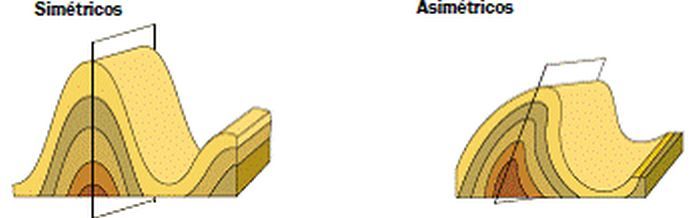
Por su simetría:
Simétricos: el ángulo (buzamiento) que forman los dos flancos con labhorizontal es aproximadamente el mismo. El plano axial suele ser vertical.
Asimétricos: los dos flancos tienen inclinaciones (buzamientos) claramente distintas. El plano axial suele estar inclinado
Por inclinación (vergencia) del plano axial:
Recto: el plano axial es vertical.
Inclinados: el plano axial forma un ángulo con la vertical
Tumbados (acostado, volcado): El plano axial es horizontal y en uno de los flancos la sucesión estratigráfica queda invertida, con los estratos más modernos debajo de los más antiguos
Por el comportamiento de los materiales:
Pliegues armónicos: Los estratos se comportan de forma parecida antelos esfuerzos tectónicos y todas las capas son paralelas entre si
Pliegues disarmónicos: Se producen cuando alternan capas blandas con capas duras que responden de distinta manera a los esfuerzos tectónicos.Las capas blandas o incompetentes se deforman iregularmente entre las capas duras o competentes que dibujan un pliegue regular. En este casose llaman pliegues de arrastre a los que se forman en las capas blandas e incompetentes
Para registrar este earthcache, enviame um correo eletrónico com la respuesta a las seguintes preguntas:
1) Según lo leido, clasifica el plegamiento que tienes ante ti. ( Sinclinal o anticlinal, simetrico o asimetrico y por su inclinación)
2) ¿Cual es el espesor de la mayor capa que forman el pliegue?
3) En el wpt: N 43° 18.171 W 002° 20.669 , viendo de frente el acantilado, al sur y en la base se puede ver un pliegue que destaca sobre los demas.
- Dame su clasificación como en la pregunta #1 y que ángulo forma su plano axial con el suelo
4) Añade una fotografia tuya en el local, u otra en la que se pueda ver algún objeto, o tu nick en un papel
-Si crees que as concluido con exito los objetivos de este Earth Cache, y me ha enviado todas las respuestas solicitadas, puede hacer el log. Luego yo comprobaré que son correctas, y si hay cualquier problema me pondre en contacto para arreglarlo.
-Logs sin respuestas enviadas previamente, seran borrados sin aviso
English (google translate)
Location
The Basque Coast Geopark is a small area wedged in between the Bay of Biscay and the Basque mountains and comprising the municipalities of Mutriku, Deba and Zumaia. At first sight, what makes the Geopark stand out is the harmony of the various tones of green of its meadows and forests that follow one after the other from the coastline and extend inland. But the true interest of this place is to be found in its bowels. Geology is the true protagonist of a landscape that preserves the history of some of the most dramatic episodes in the Earth’s recent history.
The 13 km of cliffs in the Geopark have a spectacular formation of rock layers known as Flysch deposits, which in the manner of a large encyclopaedia show us over 60 million years of the history of the Earth. Geologists and visitors can walk along these cliffs or go on a boat trip and sail across time to discover, for example, the thin black layer that indicates the impact of a giant asteroid and the wholesale extinction of the dinosaurs about 65 Ma ago
Punta Aitzandi folding
Punta de Aitzandi, formed by the black Flysch of the Cretaceous inferior, contains one of the best examples of a fallen fold of the entire basin. It is a fold of HF dimensions with a fairly tight hinge and very straight flanks. The axial plane is practically horizontal. The folding seems to be related to a fault located about 100 meters to the south, and could be interpreted as a fold of drag, which has been subsequently tilted to the current horizontal position
Folds
A fold is a secondary structure resulting from heterogeneous ductile deformation, which manifests as one or several undulations of its original elements. When this happens, the rocks undergo a modification in their geometry, which is recognized when the rocky bodies present some flat or linear rectilinear feature, before the deformation, the most common previous feature is stratification.
The folds are originated by compression efforts on the rocks that do not break them; on the other hand, when they do, so-called failures are formed. They are usually located at the edges of tectonic plates and obey two types of forces: lateral, caused by the interaction of the plates (convergence) and vertical, as a result of the lifting due to the phenomenon of subduction along a zone of subduction more or less wide and elongated, in which the mountain ranges or reliefs of folds rise.
The Factors That Controls Deformation
-Pressure and temperature
-Resistance of the materials: The rocks composed of minerals with strong internal molecular bonds tend to break by fractures, while the rocks with weaker bonds are more sensitive to the ductile flow
-Time Geological
Folds´ elements
Hinge: area of greater curvature of the fold.
Hinge line or fold axis: line joining the points of greater curvature of a surface of the fold
Direction: angle that forms the axis of the fold with the north-south geographic direction
Axial plane: plane that contains all the hinge lines and cuts the fold
Core: more compressed and more internal part of the fold
Limb: halves in which it divides the axial plane to a fold
Pitch: angle that forms the fold axis with a horizontal line contained in the axial plane
Ridge: highest area of a convex fold up
Valley: lowest area of a concave fold up |
|
TYPES OF PLIEGUES
They can be classified according to various factors independently
By the arrangement of the layers:
Anticline: the oldest materials are located in the core of the fold. Generally they have the shape of a vault
Syncline: the most modern materials are those located in the center or center of the fold. They are generally shaped like a bucket
Synclines and anticlines tend to appear alternating
By its symmetry:
Symmetrical: the angle (dip) formed by the two sides with labhorizontal is approximately the same. The axial plane is usually vertical
Asymmetrical: the two flanks have clearly different inclinations (dips). The axial plane is usually inclined
By the axial plane inclination :
Straight: the axial plane is vertical
Inclined: the axial plane forms an angle with the vertical
Lying down (lying down, overturning): The axial plane is horizontal and on one of the flanks the stratigraphic succession is inverted, with the most modern strata below the oldest
For the behavior of the materials:
Harmonic folds: The strata behave similarly to the tectonic forces and all the layers are parallel to each other
Disharmonic folds: They occur when alternating soft layers with hard layers that respond differently to tectonic efforts. Soft or incompetent layers deform iregularly between hard or competent layers that draw a regular fold. In this case they call trailing folds that are formed in the soft and incompetent layers
To log this earthcache, send me an email /message with the answer to the following questions:
1) As read, classify the folding that you have before you. (Syncline or anticline, symmetric or asymmetric and by its inclination)

2) What is the thickness of the largest layer that form the fold?

3) In the wpt: N 43 ° 18.171 W 002 ° 20.669, looking in front of the cliff, to the south and in the base you can see a fold that stands out over the others.

- Give me its classification as in question # 1 and what angle its axial plane forms with the ground

4) Add a photo of yourself at the place, or another in which you can see an object, or your nick on a piece of paper
-If you believe you have successfully completed this Earth Cache goals and has already sent to me all the requirements as requested, Please, feel free to log it as found. Later i will verify the requirements sent and, if necessary, contact you in order to make the necessary corrections to your log.
-Logs without answers, will be deleted without notice.