This earthcache is just off The Cabot Trail, inside the Cape Breton Highland National Park. You will be required to have a valid park pass to visit the earthcache.
To log this earthcache, please don’t stress about answering the questions. Simply send your best attempts in a private message to me, (the cache owner), and then go ahead and log it as found.
You don’t need to wait for my approval. All attempts will be accepted.
Go ahead and have fun learning! 
- [REQUIRED] Please post a photo in your log of yourself or a personal item at the outcrop to prove you visited the site.
- From ground level at GZ, can you see the narrow basalt dykes crossing the exposed upper portions of the cliff?
- Describe the colour of the basalt dykes as compared to the surrounding granite?
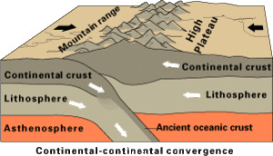
In this area of Cape Breton, Ganderia collided with Laurentia during the Silurian period. Then the microcontinents of Avalonia and then Meguma arrived behind it, squeezing Ganderia against Laurentia as the continent grew.
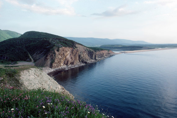
Here you can see evidence of the forces at work during this continental rearrangement. The “great cliff” stretches for 600 metres beside the Cabot Trail north of Petit Étang. There is a visible dark layer of basalt that erupted onto the surface about 375 million years ago when Avalonia collided with Ganderia and then the basalt cooled.
The granite at this site is the oldest, and formed first. Then basalt formed on top of it, followed by brick red sedimentary layers that formed over the basalt.
The basalt magma intruded the 550-million-year old granite body about 375 million years ago and flowed out on top of it. Then the sediments were deposited. Then the granite, basalt, and sediments were thrust together over a different part of the same basalt and red sedimentary rocks. The thrust contact is marked by white calcite veins deposited from water that infiltrated along the fault zone. The older granite was pushed upward and westward over the basalt early in the Carboniferous period. Magma flowed through the older rock formations of granite, on its way to the surface. Today, an immense mass of older pinkish-grey granite sits above the younger basalt.
There are narrow, dark grey dykes slicing at a low angle across the granite near the top of the cliff.
The granite in the upper part of the cliff is shattered by numerous cracks and fractures, from travelling along the fault. Over time, a huge wedge-shaped pile of broken pieces has accumulated along the base of the cliff, in most places obscuring the basalt below it.
The loose material is called scree or talus and is unstable and unsafe to climb.