THE TOTEM POLE
“The Totem Pole is hands-down the world's most spectacular sea-stack, and probably the most spectacular natural stone tower of any kind on Earth. Bound to inspire awe in the hardiest of hard-men, this thing just begs to be climbed." - www.mountainproject.com
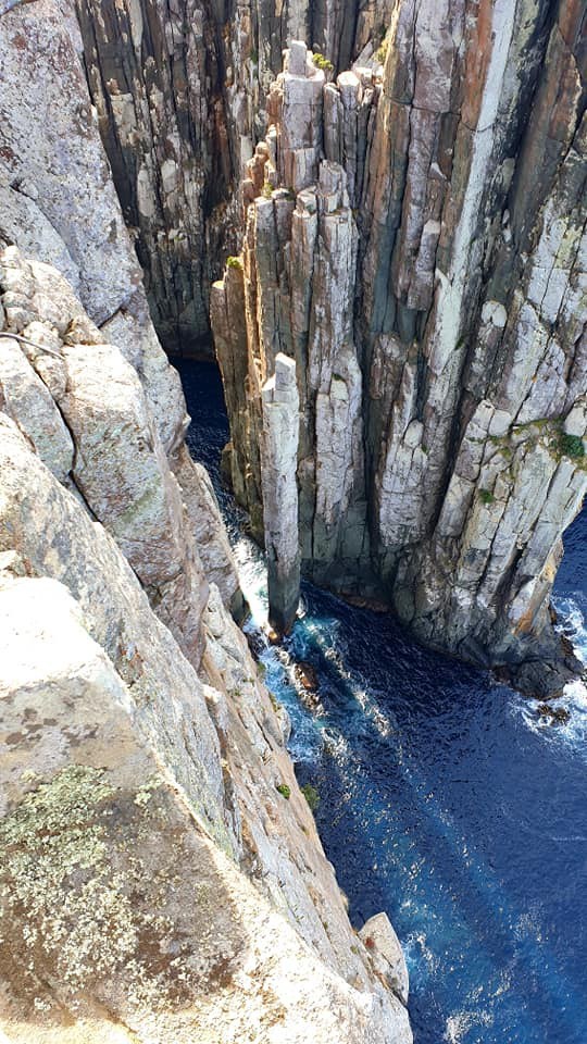
One of Tasmania's most fascinating geological features, the Totem Pole, is an incredible dolerite sea stack located at Cape Hauy in Fortescue Bay within the Tasman National Park, south east Tasmania. Notoriously dangerous and unpredictable amongst daredevil rock climbers, the rock became famous in 1998 following the accident that almost took the life of one of Britain’s leading climbers and mountaineers, Paul Pritchard. Amazingly, eighteen years later and suffering from hemiplegia, Pritchard returned and conquered the climb with the help of his friends and fellow climbers. This incredible feat was filmed and made into a documentary titled ”Doing it Scared”.
In recent years, Cape Hauy has increasingly become a popular destination for tourists with the opening of the Three Capes Track. Those that make the journey here are treated to a breathtaking view at the lookout, however many fail to 'look over the edge' to witness the Totem Pole, and it’s big brother, The Candlestick down below. Alternatively, there are several boat cruises that regularly tour the Tasman Peninsula including Cape Hauy.
SEA STACKS
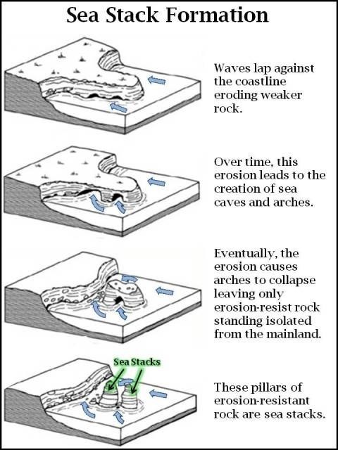
A sea stack is a form that is defined by steep and mostly vertical columns of rock that have been isolated from the coast due to erosion from the winds and waves. In time, erosion causes sea stacks to eventually collapse.
What makes the Totem Pole so special is the fact that geologists estimate that it has been standing tall for roughly about a hundred years. Considering the erosion that the base of the Totem Pole is subjected to, due to the constant action of the waves, some might consider the fact that it is standing at all to be a miracle of nature. With a diameter of only 4 metres, the Totem Pole should have collapsed a long time ago. So what are you waiting for? Get there before it disappears!
DOLERITE
Dolerite, an igneous rock, is exposed over half of Tasmania. The good physical and chemical properties of the rock make it suitable for a wide variety of uses. Crushed rock is used as aggregate in concrete, as road sub-base and in flush seals, as facing stone in building construction, and as armour stone and rip-rap.
Dolerite is composed of two essential and several accessory minerals. The essential minerals are plagioclase feldspar and pyroxene, which together constitute between about 60% and 80% of the total rock composition. The accessory minerals are quartz, orthoclase, chlorite and magnetite. Quartz, orthoclase and chlorite may comprise 20% to 40% of the rock while the magnetite composition may be 2% to 3%.
Tasmania is known for its impressive dolerite columns, formed in the Jurassic period about 185 million years ago by volcanic activity. These rocks, which protrude up to 300 metres above sea level, are what geologists call dolerites.
Dolerites form when volcanic activity pushes magma from the ground, which when cools crystallizes to form small visible crystals in the rock. When the rate of cooling is just right, the rocks shrink causing cracks. These cracks allow the rocks in the interior to cool, resulting in more cracks. Eventually, the result is a large block of rock with long vertical and symmetrical cracks creating five or six sided columns. The columns vary in size between just a few centimetres to over several meters in diameter.
Further information on the formation of dolerites with their distinct elongated shape and hexagonal columns is explained in the nearby earthcache GC6YD79 “The Pillars at the Bottom of the World”.
YOUR TASKS TO LOG THIS EARTHCACHE
In order to log this EarthCache, you must visit the location and answer the following questions:
- Using the information above, briefly explain how you think the Totem Pole was formed
- Do you think the Totem Pole follows the typical formation of a sea stack where an arch or sea cave is created through erosion and then collapses (as in the diagram “Sea Stack Formation” above)? Explain your answer
- Estimate the height and width of the Totem Pole (in metres)
- OPTIONAL – Take a photo of yourself and/or GPS at the lookout
Please then email, or send a message (through geocaching.com), your answers to the above questions. Feel free to log your find in anticipation - we'll let you know if there are any issues. Logs without the emailed answers may be deleted.