Illawarra Escarpment
An Escarpment is an area of the earth where the elevation changes suddenly. In other words, a cliff that separates two level land surfaces, as in the case of the Illawarra Escarpment that separates the lower coastal lands from the higher plateau. Escarpment usually refers to the bottom of a cliff or a steep slope, while Scarp refers to the cliff itself.
Escarpments are formed by one of two processes: erosion and faulting.
Erosion wears away rock through wind or water. One side of an escarpment may be eroded more than the other. Faulting is the movement of the earths crust along a crack called a fault that creates escarpments as it moves pieces of the earth around. Also, one side of an escarpment could be rock from one geologic era, while the other side could be rock from a different geologic era.
Escarpments are found on every continent, even Antarctica. The earth isn't the only place on which you'll find escarpments. Rupes are escarpments on other planets or moons. There are rupes on earths moon, Mercury, Mars, and the rocky moons of other planets. Rupes are created by faulting, erosion, or the impact of a meteorite. Rupes is the Latin word for cliff.
Illawarra Escarpment
The Illawarra Escarpment extends for some 120km and dominates the plains below. It is often regarded as beginning at Stanwell Park, yet it extends farther northward forming the cliffs of the Royal National Park. Along its northern extremity cliffs are of 200 to 300 metres, and near Albion Park the escarpment increases from about 350 to 650 metres, and thereafter remains fairly constant between 650 and 700 metres. To the south the the escarpment heads east until its foothills reach the sea between Kiama and Gerringong. The main escarpment then heads southwest and near Nowra turns westward being traced as far as the junction of the Kangaroo and Shoalhaven Rivers where it becomes indistinguishable in a complex network of canyons and cliffs.
Rocks which form the escarpment were deposited in an area known as the Sydney Basin, at the close of the Triassic period. Hawkesbury sandstone which lie near sea level in the centre of the basin can be traced to elevations of 600 metres near Kiama and Nowra.
It was originally thought the escarpment was a result of large scale faulting with the plateau being uplifted and the lowland remaining at sea level. Individual beds of rock can be traced from the lowland right in under the escarpment without any evidence of faulting. The escarpment we see today is the product of erosion and gravitational movement of debris down-slope that has gone on over an extremely long period of time.
The flow patterns of the streams on the Illawarra plateau follow the fall of the Hawkesbury sandstone draining into the Nepean River system, with the exception of the Macquarie and Minnamurra Rivulets. No river systems have breached the escarpment. This has left the tops of the escarpment to slowly erode.
Erosion
Erosion is the process by which soil and rock are removed from the Earth's surface by natural processes such as wind or water flow, and then transported and deposited in other locations.
The escarpment cliffs and plateau are comprised of durable quartz sandstone with weaker rapidly eroding claystone underneath which undermines the sandstone causing it to break away dropping large pieces of rock at the base of the slopes along with thick layers of material on the lower slopes and foothills formed from landslides.
The slopes extending from the cliffs down to the coastal plain consist of shale, clay stone and rich coal seams, and are covered with vegetation. Lush rainforests are supported by the high nutrient levels of the shale and claystone.
In many places, erosion-resistant layers of rock, known as strata (plural; stratum, singular) protrude forming flat benches.
Streams suck as Barrengarry Creek, Kangaroo River and Gerringong Creek have eroded the rock cutting into the cliffs to form the waterfalls of Belmore Falls, Carrington Falls and Gerringong Falls respectively.
Minnamurra slot canyon is another example of weathering. A large natural amphitheatre carved into the escarpment by the Minnamurra River; and the slot gorge, another example of erosion of a volcanic dyke, approximately 10 metres wide, 50 metres long and 50 metres high.
Types of Erosion:
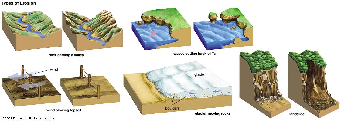
Splash Erosion - Small soil particles are detached and sent airborne through the impact of raindrops on fine ground particles.
Sheet Erosion - Raindrops break apart the soil structure and groundwater moves it down hill as it passes over as a sheet rather than definitive channels.
Rill Erosion - Small, short-lived, concentrated flow paths develop which create a sediment source and delivery system for hill-slope erosion. Areas where precipitation rates exceed soil infiltration rates are more prone to this type of erosion.
Gully Erosion - during or directly following heavy rain water flows in narrow channels and can erode gullies to considerable depths.
Valley or Stream Erosion - Continual water flow alongside land (along a linear feature) creates this type of erosion. It extends downward, deepening a valley, and head-ward, extending the valley into the hillside. This occurs most frequently in times of flooding.
Bank Erosion - Over time, banks of rivers and streams are naturally worn down.
Freezing and thawing - Cold weather causes water trapped in tiny rock cracks to freeze and expand, breaking the rock into pieces.
Wind erosion - Wind erosion comes in two forms: deflation, where the wind picks up and carries away loose particles; and abrasion, where surfaces are worn down as they are struck by airborne particles carried by wind. It can cause significant economic and environmental damage.
Mass movement - is the downward and outward movement of rock and sediments on a sloped surface, mainly due to the force of gravity. Mass movement is an important part of the erosion process, and is often the first stage in the breakdown and transport of weathered materials in mountainous areas. It moves material from higher elevations to lower elevations where other eroding agents such as streams can then pick up the material and move it to even lower elevations. Mass-movement processes are continuously occurring on all slopes; some mass-movement processes act very slowly; others occur very suddenly, often with disastrous results.
Ref: R W Young (1979) The Illawarra Escarpment, University of Wollongong.
Logging Requirements:
Please submit your answers to the questions to me via the above links. Should any clarification be needed I will contact you.
You may log your find immediately, however please be aware that if the logging logging requirements are not met and within 10 days you risk your log being deleted. Thanks.
QUESTIONS
There are an abundance of vantage points throughout the Wollongong area in which you can closely observe the Illawarra Escarpment in order to answer the questions. You do not need to go to the specified reference points. Provide satisfactory answers plus a suitable photo.
1. What type(s) of erosion would likely be attributed to the Illawarra escarpment, explain your reasoning?
2. How can an escarpment and a cliff be differentiated?
3. Please take a photograph of yourself, your gps or a personal item at any location in Wollongong that gives a good view of the escarpment as your background.
A few reference points are listed for those unfamiliar with the Illawarra area. One of the best areas for referencing is between Dapto and Albion Park where you can observe from a distance or get in nice and close.