UPDATE 7/1/2019 & REVISED 8/30/2019: The signs are gone. Go to each stage and click on Informational Sign # in the question section to see it. If you do not have access to a device to see it while you are here, scroll down and read it from description at bottom. This is still a short four stage earthcache. Go to each stage and look at the sign (either where question is asked (photo) OR at bottom of description (text)). HAVE FUN!
The posted coords are for the parking area. The park is open from sunrise to sunset.
Although Siler City has a large area of flood zones, there is one area north of Boling Lane Park that continues to flood and roads are closed during heavy rains. This earthcache will explain about flood zones and how the town and others were trying to help the flooding problem by installing stormwater wetlands and creek buffers.
The stormwater wetlands were constructed not only to alleviate flooding in the park, but also flooding beyond. While on the walking trail, look around and think about where all the water coming into the park has to escape (flow).
Although 'Urban Drainage Basins" is not a problem at the park, the water from the park flowing into the area beyond is. To see the 'Urban Draingage Basin' problem look at the area at N 35 43.246 W 79 28.146. There you will see a large parking lot. The water damaged the parking lot and at the present time (2019) the parking lot has been ground up and it is my understanding that the area will be repaved after drainage for the water has been added.
|
FLOOD ZONE
8 MOST COMMON CAUSES OF FLOODING
(1) Heavy Rains
- Light rainfall is considered less than 0.10 inches of rain per hour.
- Heavy rainfall is more than 0.30 inches of rain per hour. Rainfall amount is described as the depth of water reaching the ground, typically in inches or millimeters (25 mm equals one inch). An inch of rain is exactly that, water that is one inch deep.
(2) Overflowing Rivers
- You do not necessarily need to have heavy rains to experience flooding in your area. For example, if you live along a river and areas upstream from you experience heavy rains, it could lead to a serious overflow where you live. Most larger rivers include a series of dams to help manage large amounts of rainfall, and most river systems are managed by government authorities.
(3) Broken Dams
- Much of America’s infrastructure was built in the 20th century, so it is getting old. When heavy rains come, and water levels rise, aging dams can fail and unleash torrents of water on unsuspecting households.
(4) Urban Drainage Basins
- Many of our cities are made of mostly concrete and other impermeable material. When you have an urban drainage basin that is made of concrete, there is no ground for water to sink into. So, when those drainage basins fill up, it is going to mean flooding for low-lying areas.
(5) Storm Surges and Tsunamis
- Rain is not always the culprit when it comes to flooding. Storm surges related to hurricanes and other storms can lead to significant flooding, as can tsunamis that are sometimes caused by underwater earthquakes.
(6) Channels with Steep Sides
- Flooding often occurs when there is fast runoff into lakes, rivers and other reservoirs. This is often the case with rivers and other channels that feature steep sides.
(7) A Lack of Vegetation
- Vegetation can help slow runoff and prevent flooding. When there is a lack of vegetation, however, there is little to stop water from running off. This can be a bit of a conundrum after a drought.
(8) Melting Snow and Ice
- The snow and ice have to go somewhere when they melt.
 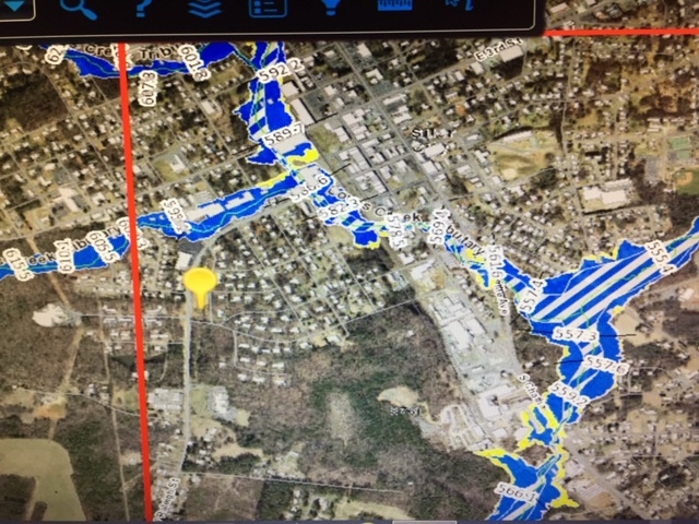 LEFT PICTURE: Flood zone for a bigger area of Siler City, NC
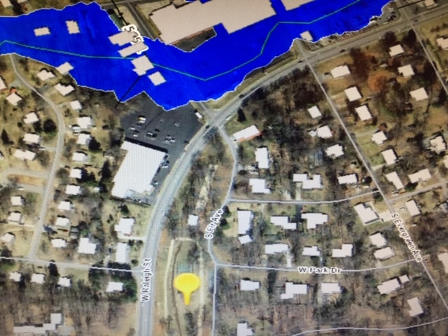
RIGHT PICTURE: Closer up picture of park and area beyond.
(yellow pin is where Boling Lane Park is located in pictures)
LEFT PICTURE: Flood zone for a bigger area of Siler City, NC
RIGHT PICTURE: Closer up picture of park and area beyond.
(yellow pin is where Boling Lane Park is located in pictures)
The reason for the large area of flood zones is that Love Creek and it's tributaries run through Siler City. Although Boling Lane Park is not in the flood zone, the area beyond the park is.
|
STORMWATER WETLANDS
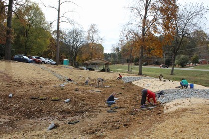
Volunteers planting the wetland.
Note the excavation of the wetlands with gravel for water flow.
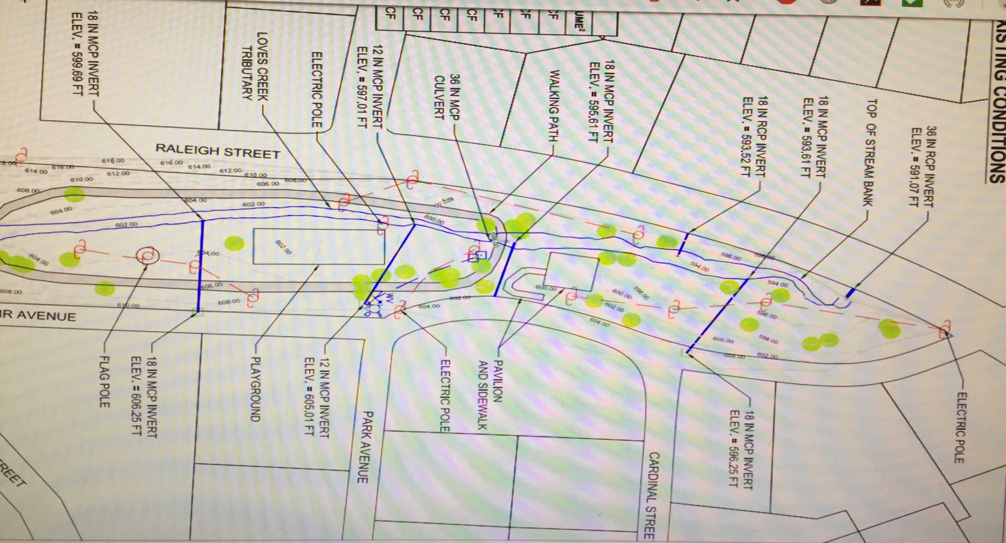 Existing condition at Boling Lane Park drawn by NCSU in August, 2017.
Note Love Creek Tributary running through park.
Existing condition at Boling Lane Park drawn by NCSU in August, 2017.
Note Love Creek Tributary running through park.
In 2017, two stormwater wetlands and a creek buffer were added to the park to help reducing flooding issues in the park while at the same time providing rich new habitat for a wide variety of plant and animals such as birds, amphibians, dragonflies and other aquatic invertebrates.
The new environmental friendly look of Boling Lane Park is a stormwater and community outreach project of the Town of Siler City and the Loves Creek Watershed Stewards, a local stakeholders group with the mission to develop and promote community stewardship of the watershed with the goal of restoring the ecological function of Loves Creek and its tributaries. The funding for the project came from the EPA Non-Point Source Planning 319 grant administered by NC Department of Environmental Quality. The wetlands were designed by NCSU Biological and Agricultural Engineering and the construction and dirt moving for the project was completed by Wright Contracting with oversight from the Town of Siler City and Piedmont Conservation Council. Planting of the wetlands and expanded creek buffers in the park were completed by Biocenosis LLC with the help of over 50 volunteers from the Siler City community, town staff, Chatham Soil and Water Conservation District office, and Jordan Matthew High School Occupational Course of Student students.
|
Using the information in the description and information you find along a .2 mile walking trail, answer the following questions at four stops and email or message me your answers to get credit for the find.
- - - - -
STAGE 1 - N 35 43.122 W 79 28.177 [Click Informational Sign 1]
Question 1: What helps stop stream bank erosion and creates streambank habitat?
- - - - -
STAGE 2 - BRIDGE (built up pavement) - N 35 43.042 W 79 28.170
Question 2: From the 8 most common causes for flood zones above, which ones can you see that caused the flooding problem and why do you think that? There are more than one cause.
[hint for one of them: look east & west.]
- - - - -
STAGE 3 - N 35 43.046 W 79 28.163 [Click Informational Sign 2]
Question 3: What might you see in the park that eat mosquitoes? Look around. Do you see any?
- - - - -
STAGE 4 - N 35 43.070 W 79 28.161 [click Informational Sign 3]
Question 4: Why are wetland plants important? Look around. Do you see any that look like the ones on the sign?
- - - - -
Please post pictures of yourself, the park, wetlands, etc., but do NOT post your answers, so others can come out and enjoy too.
|
A big CONGRATS to Setenta Tres for FTF!
Great job on answers!
|
INFORMATIONAL SIGNS
Sign 1: Stream Buffers - Protect water quality and create habitat
Stream buffers are areas of trees, shrubs, and grasses next to a stream. These plants slow down runoff from rainfall and allow it to soak into the ground. They also provide food, shelter, and shade for fish and wildlife. Plant roots help stop stream bank erosion and create streambank habitat. A healthy stream buffer supports a rich and diverse ecosystem.
Sign 2: Helpful Mosquito Predators - Mosquitoes are rare in a healthy wetland
Healthy wetlands provide abundant habitat for natural mosquito predators like bats, frogs, salamander larvae, fish, damselflies, dragonflies and their larvae and other aquatic insects. A healthy functioning wetland can actually reduce mosquito populations. Mosquitoes usually become a problem in areas that don't support these beneficial species. For example, standing rainwater found in old tires, birdbaths, flowerpots and other containers doesn't attract natural predators, and allows mosquitos to multiply.
Sign 3: Aquatic Plants - The key to a healthy wetland
Wetland Plants can be semi-aquatic or aquatic. Their roots can tolerate being under water unlike many terrestrial plants. Wetland plants are important because they serve as food and cover for aquatic birds, insects, reptiles, amphibians and mammals. They also help improve water quality by removing pollutants from the wetland through there roots.