위 이미지(지형도)와 아래 이미지(단면도)는 울릉도의 이중 화산체를 살펴보기 좋은데 등고선 간격이 넓은 나리분지 가운데 부분에 알봉이 솟아 있는 것을 볼 수 있다. 위 그림과 아래 그림을 비교해서 살펴보면, 단면도에서 AA'와 BB' 중간에 솟아있는 부분이 알봉이라는 것을 알 수 있다.
Two images(Topographic map & Cross-sectional diagram) refer to the double volcanoes of Ulleungdo island. You can see Albong peak in the middle of Nari basin with a wide contour line. When we compare two images, you can notice that the hilltop in the middle between AA 'and BB' in the section is Albong peak.
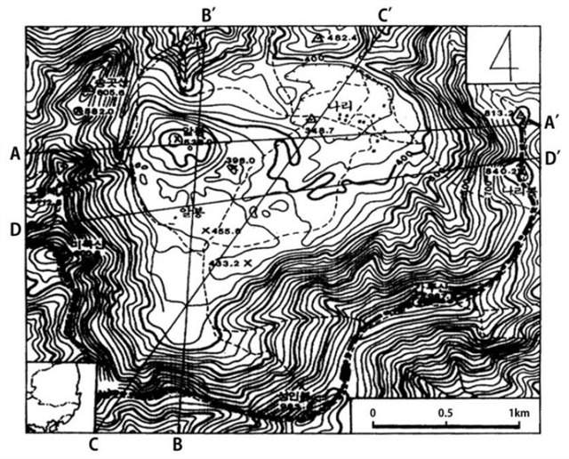
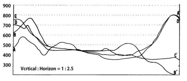
위 단면도를 보면 외륜산과 알봉 사이. 즉, 나리분지의 평평한 부분이 보이는데, 이곳에는 부력, 화산회, 화산력 등이 퇴적되어 있어 마치 충적 선상지처럼 느껴지기도 한다.
In the cross-sectional diagram you can see the flat part of the Nari basin between outer ring and Albong peak. Buoyancy, volcanic ash and lapilli are deposited here, which looks like an alluvial fan.
이와 같이 칼데라 내부는 화구가 함몰된 이후 퇴적된 퇴적물들이 쌓여 있으며 현재 나리분지와 알봉분지의 외곽은 함몰시에 만들어진 급경사의 절벽으로 둘러싸여 있다.
After the collapse of the volcanic crater sediments accumulated inside the caldera. The outskirts of Nari basin and Albong basin are surrounded by steep cliffs formed at the time of volcanic crater collapse.
나리분지와 알봉의 형성과정(Formation of Nari basin & Albong peak)
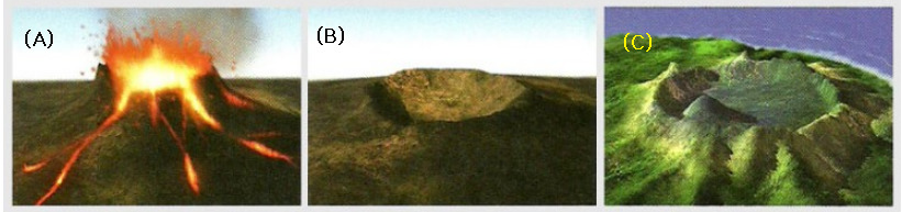
(A) 울릉도 중앙 화구를 중심으로 여러 차레 막대한 양의 용암이 분출하여 화구 주변에 거대한 화산체가 형성되었다. A huge volcanic body was formed around the central crater by repeated eruptions of enormous amount of lava.
(B) 약 1만년 전 대폭발과 함께 지하 내부에 빈 공간이 생기자 화구가 크게 함몰하여 칼데라인 분지가 형성되었다. When a large explosion created an empty space deep underground about 10,000 years ago, the crater collapsed in a large scale and a caldera, Nari basin, was formed.
(C) 이후 약 6300년 전 분지 북서부에서 또 다시 분화 활동이 일어나 화산재와 화산 쇄설물이 쌓여 알봉이 형성되었다. Then another eruption took place in the northwest of the basin about 6,300 years ago, creating a pile of volcanic ash and Pyroclastic material. This way Albong peak appeared.
칼데라의 종류(Types of Caldera)
함몰형 칼데라 : 화산의 폭발 이후 화산 하부의 마그마방이 텅 비면서 화산 화구 아래쪽이 그대로 무너져 내리면서 칼데라가 생성되는 방식이다.
폭발형 칼데라 : 화산의 분출 당시 화산 마그마에 수분이 유입되면서 수증기의 압력으로 폭발성 분화를 하는 경우이다. 분화의 압력으로 산봉우리 부분을 통째로 날려버리는 방식으로 칼데라가 생성된다.
Collapse calderas form when a large magma chamber is emptied by a volcanic eruption or by subsurface magma movement. The unsupported rock that forms the roof of the magma chamber then collapses to form a large crater. Crater Lake and many other calderas are thought to have formed by this process.
Explosive calderas are formed when very large magma chambers filled with silica-rich melt and abundant gas move upwards from depth. Silica-rich magmas have a very high viscosity that enables them to hold gas bubbles under very high pressures. As they rise to the surface, the reduction of pressure causes the gases to expand. When break-through occurs the result can be an enormous explosion which blasts away large volumes of rock to form the caldera. Some of these blasts eject many cubic kilometers of magma and rock.
칼데라호(Caldera lake)
칼데라 안에 물이 괸 호수로서, 호안은 경사가 급하며, 수심이 크고 밑바닥은 대체로 평탄한 것이 많다. 백두산의 천지는 한국에서 유일한 칼데라호이다.
There is a water lake in the caldera, the shore is steep, and the bottom is generally flat and the bottom is mostly flat. Chunji is the only caldera lake in Korea.
[로그하는 방법]
- 전망대에서 나리분지의 외곽을 관찰해 보자. 외곽의 지형적인 특징은 무엇인가? 그러한 지형이 만들어진 이유는 무엇인가?
- 순상화산(楯狀火山, shield volcano)은 점성이 낮은 현무암질 용암의 분출·유동·퇴적에 의해 형성되며 완만한 경사면을 가진 밑바닥의 면적이 넓은 화산이다. 전망대에서 알봉의 특징을 살펴보자. 알봉은 순상화산인가 아니면 반대의 특성을 가진 종상화산(鐘狀火山, tholoide)인가? 그렇게 판단한 이유는 무엇인가?
- 울릉도의 연평균 강수량은 한국 평균과 비슷한 1300mm 정도이다. 따라서 나리분지는 비가 많이 오는 여름철에는 작은 칼데라 호수가 된다. 전망대에서는 다른 계절에도 호수의 흔적을 발견할 수 있다.(진실/오류) 그리고 당신이 관찰한 내용을 설명하세요.
- 나리분지는 화산의 분출로 산봉우리가 통째로 날아가번린 폭발형 칼데라다.(진실/오류)
- 전망대에서 알봉을 배경으로 당신 또는 당신의 GPS를 찍은 사진을 로그에 올려주세요. (선택사항이지만 사진을 올려주시기를 부탁드립니다.)
- 답을 제 Profile에 있는 메시지창을 이용해 제게 보내주세요. 이제 로그하셔도 됩니다. 답에 문제가 있을 경우 제가 메시지를 드리겠습니다.
[How to log]
- Let's observe the outskirts of Nari basin from the observatory! What are the topographical features? Why was such topography created?
- The shield volcano is formed by the eruption, flow and sedimentation of basaltic lava with low viscosity, and it is a volcano with a wide bottom area with a gentle slope. Let's look at the characteristics of the Albong peak from the observatory. Is the Albong peak a shield volcano or a tholoide volcano with opposite characteristics? Why did you think so?
- The average annual precipitation on Ulleungdo island is about 1,300 millimeters, similar to the Korean average.Therefore, the Nari basin becomes a small caldera lake in the rainy summer season. From the observatory you can observe the trace of the lake even in other seasons.(True/False) And explain what you observed!
- Nari basin is explosive caldera where an enormous explosion blasted away large volumes of rock to form the caldera.(True/False)
- Upload the photo of you or your GPS with Albong peak at the cache zone in the background! (The task is optional but I would highly appreciate if you would do so.)
- Please send the answers to me by message on my profile! You may log as 'Found'. If the answer is not correct, I will contact you.
*** Terrain rating : If you are in Ulleungdo island, it would be 1.5 instead of 4.5.
Ref : Ulleung County, Wikipedia, 박희두 1997 울릉도의 자연지리, 이우평 2007 지리교사 이우평의 한국지형산책1
| I have earned GSA's highest level: |
 |