Whilst many features of the Afan Valley's industrial past have gone, several of the bridges remain - each different in their construction and design. Pontrhydyfen, a former coal mining community is distinguished by two large 19th-century bridges that span the valley: a railway viaduct (the Red Bridge) and a former aqueduct known in Welsh as Y Bont Fawr ("The Big Bridge"). Both span exposed bedrock in the river.
(AFTER PROLONGED HEAVY RAIN OBSERVATIONS WILL BE "DIFICULT!!")
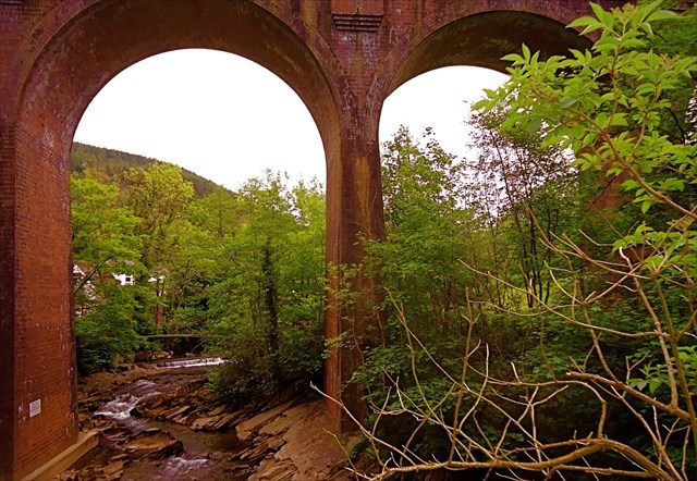
You are standing on a narrow footbridge over the river, near the centre. LOOK BELOW.
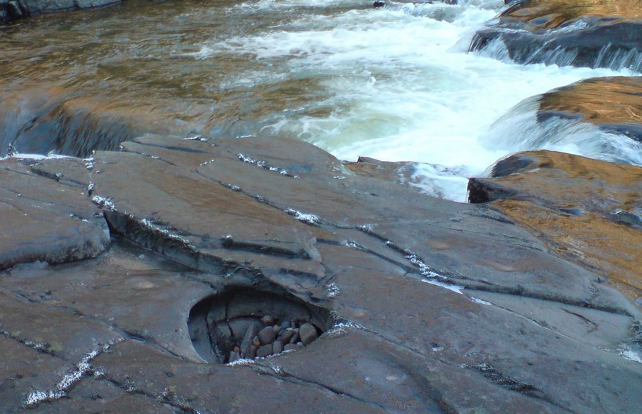
This EarthCache involves the potholes you will see in the river bed, below, similar to this example.
Pebbles will only be able to erode a river’s bed though if the rock the pebble’s made of, is stronger than the rock the river bed is made of.
In the process the stones and pebbles wear away at themselves as well as the bedrock until they are small enough to get out of the hole and they are replaced by other pebbles until the hole fills in, or a pebble breaks through the downstream side of the pothole.
You can only expect to find potholes in rivers that have rocky beds, and most commonly only rivers where the rock is uniform, in this case it’s Pennant Sandstone.

Potholes do not form in rivers whose beds are covered with pebbles, silt or mud, and so will not be found in slow wide parts of the river.
Research articles say that the general trends demonstrate that both the diameter and depth of potholes increase over time but in different rates: deepening is significantly faster than widening.
Geologists recognize two kinds of potholes in bedrock channels - vertical and lateral.
Vertical potholes formed on rock surfaces that were at one time part of the channel's rock floor. These potholes are now exposed because that portion of the channel has been raised above the active river.
Vertical potholes can be several meters deep and across. Viewed from the top, they are almost round and cut nearly vertically into the rock. If you clear the hole of its accumulated debris, you might see at the bottom spoon like depressions separated from each other by water-smoothed ridges.
The second kind, lateral potholes, tell a different story. These potholes cut into the rocky sides of channels or into sides of rocks that stuck out of the channel as mini-islands.
Lateral potholes commonly have an overhanging part and have shallow, simple basins, in contrast to the complex chambers of vertical potholes. Lateral potholes, were once considered remains of a broken vertical pothole.
To claim a find for this EarthCache, you must make a thorough examination of the area around the published coordinates, and provide answers to the questions below to the cache owner via the message or email link in our profile.
Your answers should be sent BEFORE the find is logged.
LOGGING TASKS
1. What are the three key elements required for a pothole to form? Are they still currently present here? Would you expect potholes to continue to form at this site as time goes by?
2. What sort of potholes can you see beneath you?
3. Estimate the diameter of the largest pot hole.
4. What type of pothole is this? (Vertical or Lateral)
5. You are likely to see sediment, stones and other material inside the potholes here. Suggest what differences you would expect between the stones you would find inside a pothole, and the material the pothole is made of?
6. At the coordinates, take a photo of yourself and / or GPS / or a personal identifier
Do not post answers in your log. You are welcome to log the cache before receiving my confirmation email. You should carry out these educational tasks as required by the EarthCaching organization, as a condition of logging the cache.
You need to submit your answers yourself. Group responses will not be accepted.. Logs that do not adhere to these guidelines will be deleted without notification. See http://www.geosociety.org/earthcache
BUT PLEASE DO NOT POST A PHOTO OF THE ACTUAL POTHOLES
FTF Honours to "___welshman 65 ___"
