Please read requirement 2 to log this cache. It is not hard.
We were lucky to receive one of the 4,000 caches and really wanted to put it somewhere special.
The site we chose is very special to us and we hope it will be to all finders in the future.
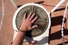
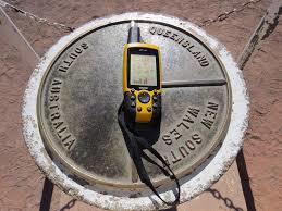
This is where the New South Wales, South Australia and Queensland borders meet, as well as many travelling tourists.
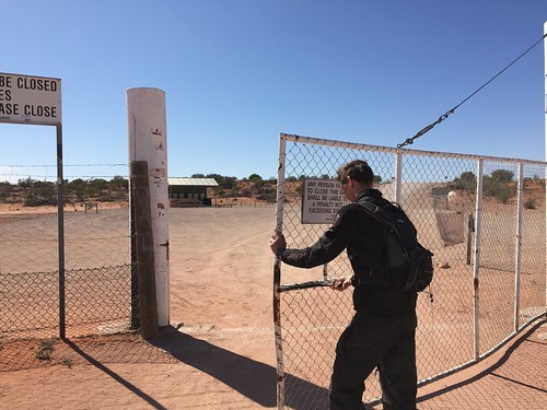
Ensure you shut any gate you pass through! Penalties apply.
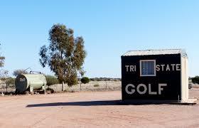 There is camping available and even a golf cource that plays through the three states, golf clubs are available for hire if you didn't bring yours.The roads here are all dirt and at times can be very corrigated but in the dry with care can be transversed by a larger 2 wheel drive. If there has been rain it will be 4X4 only, the roads will be closed if too wet. There is even an airfield within walking distance if you care to take the easy way in.
Things were not as easy back in 1879 when this site was surveyed . The official survey of the 29th parallel was conducted by J. B. Cameron (New South Wales) and G. C. Watson (Queensland) in the period 1879 to 1881, and in John Cameron's own words, this is how the survey went. (un edited)
" Trig Branch
17 January 1881
Sir
I have the honour to transmit the following report of the Colony boundary between New South Wales and
Queensland.
(1) On the 15 September 1879 I commenced by turning the angle from the Meridian line to vanes erected on the “Warrego”, took 78 angles built three concrete obelisks one on east bank of the “Warrego” one five miles west, and one five miles east.
(2) Had great difficulty in crossing creeks with the whole camp. The “Irarah”, Cuttaburra and “Warrego”
being flooded: - “Irarah” being one mile wide and Warrego 20 chains wide. I had to construct two boats one of planks and another of canvas and frame: the latter being the most useful: ferried eight (8) tons with this boat in one afternoon including instruments.
(3) Dense gidyah and mulga scrub between “Warrego” and “Hungerford” (on the “Paroo”) and had to cart water 25 miles on this stage.
(4) Erected latitude stations at the following sites at 54 miles, 76 miles, 156 miles, 210 miles and at 268 miles; built two brick obelisks at “Hungerford” one at 76 miles and one at 76 miles 65 chains.
(5) On the completion of the latitude observations at “Hungerford” Mr. Hely (Officer of Customs) kindly lent me a boat and which after a couple of days spent in repairs enabled us to cross the “Paroo”. The men were obliged to cut the line waist deep in water for over a mile.
(6) At the 85 mile post I and a blackfellow went ahead to look for water between the “Paroo” and the “Bulloo” after three days exploring found none within 25 miles of the line.
(7) At the 100 mile post Mr. G C Watson had instructions from his department to withdraw his party owing to the waterless country ahead; and expense for extra equipage.
(8) I was determined to carry the work out at all hazards and engaged an extra team of six horses and bought two extra horses for my own camp making a total of 14 horses carting water.
(9) At the 108 mile post I started again with blackfellow to explore Westward to Wahpah Creek after traversing 190 miles we only found a little electro plated water on the clay pans left by the recent shower as this would evaporate in a few days with the sun. I sent two men ahead to drain it into small
tanks; Had to cart water 53 miles at this stage. At the 140 mile post I was obliged to go ahead with all the horses by a compass bearing to “Bulloo Downs” 90 miles the nearest known water. I took four men, dray, tank, and buggy to make a track to the water if we found any. At “Bulloo Downs” we were
informed that there was no water except at “Booka Booka” 18 miles north of a point on the line 188 miles from “Warrego”;
On our way back found a little muddy water at the 156 post; at this point one of the hands (Lindsay) got seriously ill with scurvy and had to be carried on a stretcher. I had to send a conveyance with him to “Yancannia” 150 miles being the nearest point to the Wilcannia Hospital: immediately after his
departure the assistant Mr. C V Brown and the Chainman Bryant were laid up, four others including myself just able to move about. I was obliged to chain, run the line, observe at night, help to cart water, and remove camp on account of being so short handed. I sent to “Wilcannia” and “Bulloo Downs” for medicine to cure the scurvy: on the return of the waggon that brought Lindsay to “Yancannia” I had to send it to Depot Glen with the Chainman Bryant about 80 miles. I engaged two fresh hands and continued the line west from Wanpah Creek knowing that there was no water between that creek and the South Australian boundary.
(10) The lessee’s contiguous to the line had to remove their stock to Cooper’s Creek for sustenance and water.
(11) At the 235 mile post we nearly lost all our horses in one night (32) owing to the teamster and blackfellow being unable to find the waterhole. They brought the horses back to camp after having traversed 90 miles. Having 100 gallons of water in camp I divided 50 gallons among the 32 horses with a little oatmeal which enabled them to travel to “Warri Warri” Creek. I travelled 50 miles on my private horse before I found this water, and then only a little by digging in the sand. I was obliged to give the horses a weeks spell to recruit their strength and also cart water to the camp 22 miles with the strongest of the horses.
(12) When at the 250 mile post I sent one of the assistants Mr. B C Boys for mail and beef to “Fort Grey” and to get information re water etc in the dark he (Boys) crossed the track leading to “Fort Grey” and meandered about the Lower Cooper Creek flats for three days and nights without food or water until his horse died, he (Boys) then carried his saddle and mail bag and tracks east and struck a cattle track about 18 miles south of the station: when he got to the station Mr. Crozier kindly attended to him and lent him horses to return to camp with beef and mail.
(13) From this (250 mile post) point to the end we had it very dry the only water being at “Fort Grey “ and no grass for a radius of 8 miles from the Lake.
(14) I intended to erect a stone obelisk at the intersection with the South Australian boundary on account
of there being no stone in the neighbourhood I was obliged to erect a post 8 feet high with large mound.
(15) On completion of the boundary we could not follow our line back to “Barringun” as there was a stage of 134 miles without water and we were obliged to go via “Bulloo Downs” and “Thargomindah” and even by this route there were stages of sixty miles without water.
(16) I think the principal cause of scurvy was bad water for four months we were obliged to drink water that the horses would not drink which we purified with gypsum when we could get it.
(17) Latitude stations were erected at an average of 50 miles, the greatest apparent error appeared at Stations No. 5 “Brindingabba Dam” 2” and at 268 miles = 2”35 the others were less than +_ one second.
(18) Time occupied for the 287 miles 60 chains being (15th Sept 1879 to 30 th Sept 1880) 12 months and 15 days.
I have the honour to be Sir’
Your obedient Servant
J B Cameron
Geodetic Surveyor"
Virtual Rewards 2.0 - 2019/2020
This Virtual Cache is part of a limited release of Virtuals created between June 4, 2019 and June 4, 2020. Only 4,000 cache owners were given the opportunity to hide a Virtual Cache. Learn more about Virtual Rewards 2.0 on the Geocaching Blog.
Due to the large amout of teams trying to armchair log this cache we have changed the requirements to log.
To log this cache all you have to do is email us the
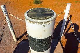
1/. Numbers stamped on the top of the corner post.
2/. In your online log ADD a picture of yourself holding your team name with the post in view OR your GPS and team name on a peice of paper at/on the corner post OR a picture of the post with your team name written in the sand, feel free to be creative.
(As of 01/10/21 any logs without pictures will be deleted)
(Please be carefull not to give anything away if you place your GPS or paper on top of the corner post.)
**Congratulations micaparamedic on the FTF.**