Waterfall Capital of the World
(Virtual Reward 2.0)
(The posted coordinates of this cache are just ONE of the places you may choose to visit to log a find on this Virtual cache)
Seventy-five kilometers northwest of Niagara Falls, on the edge of Lake Ontario, you'll find the Canadian port city of Hamilton - otherwise known as the "Waterfall Capital of the World". And it's not just marketing hype - according to the Smithsonian, due to it's location on the Niagara Escarpment, a rock ridge stretching 725 kilometers in it's Ontario portion, Hamilton is home to more than 100 waterfalls within city limits.
Smithsonian actually reports 156 waterfalls, the most in any city in the world. And if one accounts for the surrounding area, there are even more waterfalls.
One thing is certain - the Hamilton area has A LOT of waterfalls.
Some of the falls are easier to get to than others - some require a bit of a hike and some are very close to parking.
Some have guided tours, self-guided tours, cycling routes to them.
Some have free parking, while others carry a fee.
So to highlight this unique and beautiful little corner of the world, this Virtual Reward cache is dedicated to some of those waterfalls of Hamilton and the surrounding area.
To claim a find, all you need is to take a picture at 5 different waterfalls. Easy right? Here are the rest of the rules,
a) Visit a minimum of FIVE of the twelve waterfalls listed on this cache page, DURING DAYLIGHT HOURS.
You can choose any five, but they MUST BE FROM THOSE LISTED ON THIS PAGE.
b) Go to the coordinate shown below for EACH of your FIVE chosen waterfalls (this is known as the "Picture Spot" coordinate). The pictures for each waterfall on this cache page were taken from the "Picture Spot" coordinate so you have an idea as to the view that should appear in your picture.
c) Take a photo at the "Picture Spot" location for each chosen waterfall with the waterfall visible in the background. The following are acceptable,
i) A picture of yourself with your face visible
ii) A picture of yourself, no face visible, but your GPS OR a piece of paper/a personal item with your caching name visible
d) Post your 5 pictures with your Found Log - no need to send them for confirmation ahead of time. I'll look at your log and if I have any questions, will reach out to you. Only those Found logs with at least 5 pictures will be accepted.
e) You can visit the five waterfalls over multiple days - you do not need to find them all in a day.
Failure to meet ALL of the above requirements, will not be considered as a find.
Please take note of ALL warning signs and postings at the falls and stay at a safe distance. This virtual cache does not require you to go against the rules put in place by the municipalities for your safe viewing and enjoyment of the falls.
Information for each waterfall is listed below along with a picture taken from the "Picture Spot" coordinate.
Enjoy your tour of the waterfalls of the Hamilton area!
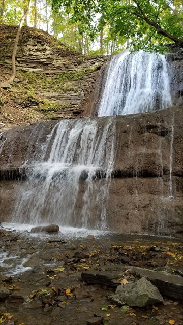
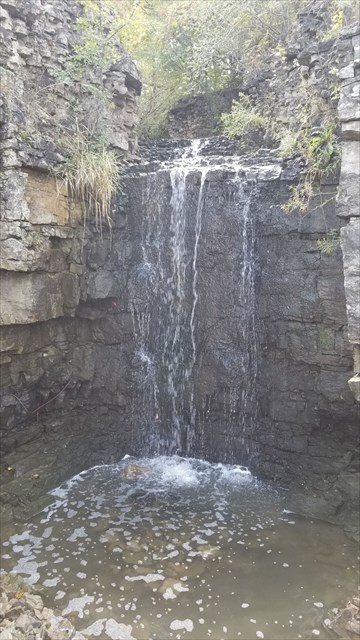
1. Smokey Hollow Falls
(Picture Spot: N43 19.828 W79 53.228)

Smokey Hollow Falls
Also known as Grindstone, Waterdown, or Great Falls. They all describe the same beautiful ribbon waterfall in it's leafy forest setting that flows from Grindstone Creek in Waterdown, Ontario. At 10 metres tall, this isn't the area's biggest waterfall, but this short and fast-flowing waterfall is surrounded by a great section of the Bruce Trail. It has a rugged footpath tracing it's way up and down the ravine formed by the Niagara Escarpment. Once used to power a local sawmill, the falls are now the centre of beautifully rehabilitated park land.
Parking: FREE lot found just off Mill St, close to Highway 5 - N43 19.850 W79 53.228
Picture Spot: Take trail from parking to stairs that lead to the upper viewing platform and stand at these coordinates for your picture - N43 19.828 W79 53.228
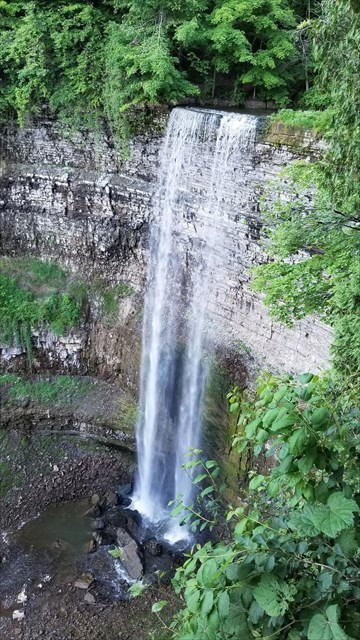
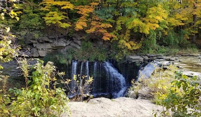
2. The Devil's Punchbowl
(Picture Spot: N43 12.676 W79 45.401)
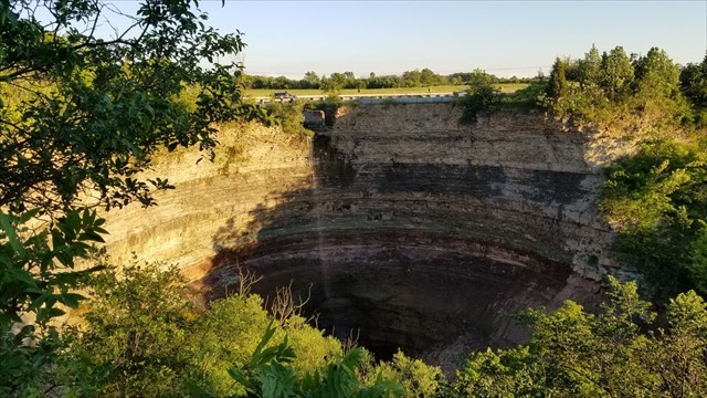
The Devil's Punchbowl
The Devil’s Punch Bowl is one of the Niagara Escarpment’s most amazing sights.
It is a ribbon waterfall, measuring 37 metres (121 feet) in height and has a crest width of 3 metres (10 feet). The creation of the punchbowl occurred at the end of the last ice age by huge melt-water rivers which rushed in torrents over the Stoney Creek Escarpment, thus carving the bowl and gorge. Here you will see colorful layers of stratified rock in a beautiful vertical display. There is a spectacular view of Stoney Creek and Hamilton Harbour from the lookout, not to mention the view down into the seemingly bottomless gorge.
A number of stories circulate as to how the Devil’s Punch Bowl got its name. There is the possibility that it was named for the pails of home brew which, at one time, was bootlegged in the surrounding woods.
While this virtual takes you to the top of the gorge, there are trails to the bottom if you would like to explore the area a bit more.
Parking: There is a fee to park here. It is $8.00/day, or you use an HCA Pass (Hamilton Conservation Authority)- N43 12.679 W79 45.287
Picture Spot: N43 12.676 W79 45.401
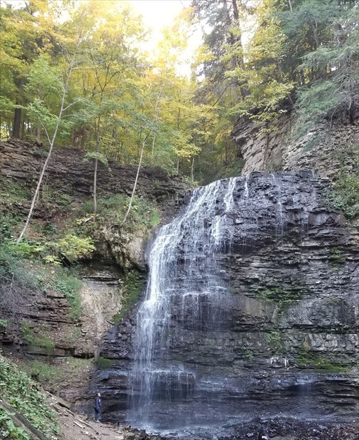
3. Borer's Falls
(Picture Spot: Either N43 17.627 W79 56.202, or,
N43 17.626 W79 56.185)
Borer's Falls
Found in the Borer's Falls Conservation Area in Dundas, Hamilton, is this 15-metre high (49ft) ribbon-style waterfall. It's source is Borer's creek, and it is also known as Rock Chapel Falls. Borer's is a very picturesque waterfall featured on many of Hamilton waterfall postcards over the years. It is named after the Borer family who ran a sawmill for over a century. This mill was the lifeblood of the village of Rock Chapel. The area is a hiker's haven and also an ice-climbing destination in the winter when the weather is cold enough to freeze the falls.
Parking: Metered parking in a lot for Borer's Conservation area, south of the falls off Rock Chapel Road - N43 17.440 W79 56.230
Picture Spot: You have your choice here!
a) You can be adventurous and take a picture at the brink of the falls here - N43 17.627 W79 56.202
b) Or you can position yourself further down the trail behind the viewing railing here - N43 17.626 W79 56.185
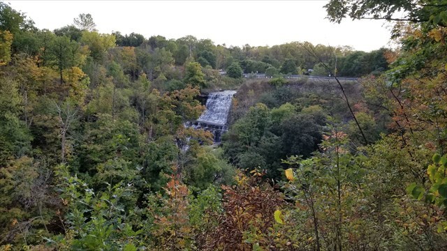
4. Webster's Falls
(Picture Spot: N43 16.553 W79 58.822)
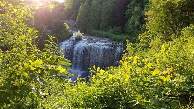
Webster's Falls
Webster's Falls, is the largest waterfall in the region. It is a 22-metre-high (72 ft), 30-metre-wide (98 ft) classical curtain/ plunge waterfall found in the Spencer Gorge/Webster's Falls Conservation Area. Originally the waterfall was known as Dr. Hamilton's falls, after Dr. James Hamilton purchased the land in 1818. The waterfall, and 78 acres (320,000 m2) of the surrounding land, were purchased shortly after by Joseph Webster when his family arrived from England in 1820. The Webster family manor still stands on Webster's Falls Road, and their gravestones have been preserved in a small section of a nearby trail.
The grounds around the falls are landscaped parkland. A cobblestone bridge stretches across Spencer Creek, upstream from the falls. Great place to picnic and spend some time.
Parking:
Depending on the time of year, and day of the week, there are different parking options.
- On weekdays any time of year, OR weekends in November through mid-April, there is a parking lot at the falls that can be used. When the attendant is NOT on duty, there is a $15.50 flat fee to park here. When the attendant is on duty, there is a fee of $10.00 per vehicle PLUS $5.00 per person in the vehicle (over 5 years old). Or you can use an HCA Pass (Hamilton Conservation Authority). This lot can be found at N43 16.610 W79 58.788.
- On weekends or holidays from mid-April through October you cannot park at the lot at the falls. There is parking at Christie Lake Conservation Area, and a shuttle service that runs to Webster's Falls. The shuttle leaves every 15 minutes starting at 9:30am, and the cost for parking and shuttle combined is $10 plus $5 per person. Or you can use an HCA Pass (Hamilton Conservation Authority). There are a few very large parking lots at Christie Lake Conservation Area, and one can be found at N 43 16.940 W 080 01.620.
Picture Spot: N43 16.553 W79 58.822
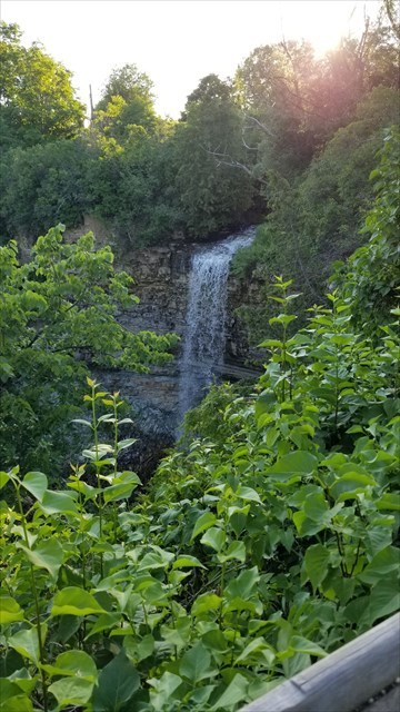
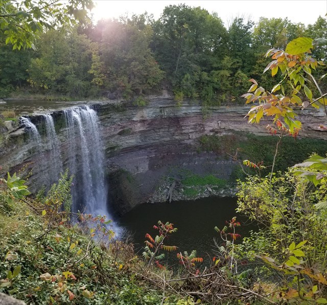
5. Tew's Falls
(Picture Spot: N43 16.846 W79 58.684)
Tew's Falls
Tew's falls is a stunning 41m (135 ft) high ribbon waterfall - the tallest in Hamilton, only a few metres shorter than Niagara Falls! - and my personal favourite.
The source of the falls is Logie's Creek. Also known as Hopkin's Falls and Tunis's Falls, it is best viewed in the springtime as it may dry up in the summer months.
The falls also marks the beginning of an uphill forested hike towards Hamilton’s famous Dundas Peak with stunning valley views.
Parking:
Depending on the time of year, and day of the week, there are different parking options.
- On weekdays any time of year, OR weekends in November through mid-April, there is a parking lot at the falls that can be used. There is a $15.50 flat fee to park here. Or you can use an HCA Pass (Hamilton Conservation Authority). This lot can be found at N43 16.900 W79 58.746.
- On weekends or holidays from mid-April through October you cannot park at the lot at the falls. There is parking at Christie Lake Conservation Area, and a shuttle service that runs to Tew's Falls. The shuttle leaves every 15 minutes starting at 9:30am, and the cost for parking and shuttle combined is $10 plus $5 per person. Or you can use an HCA Pass (Hamilton Conservation Authority). There are a few very large parking lots at Christie Lake Conservation Area, and one can be found at N 43 16.940 W 080 01.620.
Picture Spot: N43 16.846 W79 58.684
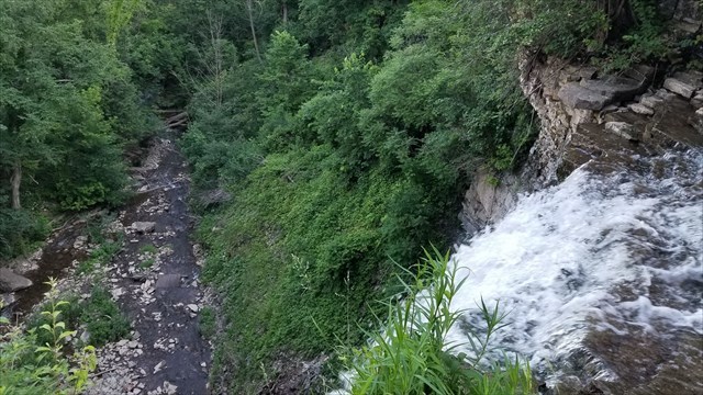
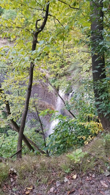
6. Sherman Falls
(Picture Spot: N43 14.292 W79 58.379)
Sherman Falls
Sherman Falls is a 17-metre-high (56 ft) curtain waterfall found in Ancaster Heights, the western end of Hamilton, Ontario, Canada. The watercourse is Ancaster Creek and there is a short rocky trail that follows the stream right up to the base of the falls. It is a very pretty waterfall, with a bridge across the creek that you can stand on to view. It is actually on private land, but the land owner provides permission to access the falls. Alternative names for Sherman Falls include; Smith's Falls and Whitton Falls. It is now apparently known as Farah Falls, after the family name of current property owners.
Parking: It may appear that Parking is free and roadside but unfortunately it is not. There is a paid lot located at 789 Artaban Rd which has a $5 Flat Fee. From here it is about a 450m walk to the falls. - N43 14.459 W79 58.545.
Picture Spot: For this one, you are going to get a little more up-close and personal with the falls - N43 14.292 W79 58.379
7. Tiffany Falls
(Picture Spot: N43 14.290 W79 57.488)
Tiffany Falls
The short walk to this expansive cascade waterfall is a beautiful one through a forested trail and over bridges that crisscross a stream. It’s an easy hike from the parking lot on Wilson Street – making it a great spot for kids and families. There’s also a connection to the Bruce Trail if you’re up for a longer hike.
This 21 metre tall (69 ft) cascade waterfall is stunning in the spring when it’s roaring from the spring melt and also in the winter when it’s frozen in place (ice-climbing is allowed at this location). The waterfall tumbles from a broad valley above the escarpment into a v-shaped ravine below, surrounded by cliffs on either side. The surrounding forest and bedrock is considered a significant natural area, with various species and a canopy that consisting of Eastern hemlock, sugar maple, red oak, American beech and many more species.
Parking: There is a small lot off Wilson Street with a $11 Flat fee. Or you can use an HCA Pass (Hamilton Conservation Authority). N43 14.428 W79 57.637
Picture Spot: N43 14.290 W79 57.488
8. Albion Falls
(Picture Spot: N43 12.076 W79 49.123)
Albion Falls
Albion Falls is almost as wide (18 metres) as it is tall (19 metres) and is one of the most picturesque waterfalls in the region. It is also one of the city’s most popular. The Red Hill Creek in the east end’s King’s Forest tumbles over rock that’s been formed over time into steps and shelves, fanning outwards into a beautiful cascade of rushing water.
Parking: Free lot at N43 12.095 W79 49.128 (this is close to the Picture Spot). For a longer walk, you could also park at this lot: N43 11.988 W79 49.270
Picture Spot: N43 12.076 W79 49.123
9. Upper Princess Falls
(Picture Spot: N43 14.753 W79 55.795)
Upper Princess Falls
Upper Princess Falls are set back in a little limestone cavern and carry Lang’s Creek over a 6.7 metre drop into a deep plunge pool. The falls are considered a complex cascade and ribbon falls, and experiences impressive flow after rain and the winter snow melt.
Parking: Free lot at N43 14.731 W79 55.851
Picture Spot: N43 14.753 W79 55.795
10. Ball's Falls - Upper
(Picture Spot: N43 07.679 W79 23.117)
Ball's Falls - Upper
Set within the breathtaking Twenty Valley, Ball’s Falls Conservation Area offers spectacular scenery and natural beauty. Your visit will begin at the Ball’s Falls Centre for Conservation where you can access trails for both the Upper and Lower Ball's Falls.
Upper Ball's falls are 11 metres high (35 ft) and classified as a Cascade Plunge waterfall.
Also contained in the Conservation area is the lovingly maintained historical village of Glen Elgin - an early mid 19th century industrial hamlet featuring the original Ball family home, an operating flour mill, a lime kiln, a church, black smith shop, carriage shed, and more.
Photographers and nature lovers alike will love the incredibly breathtaking view of the majestic Twenty Mile Creek as it plummets over both the upper and lower falls. The character of the falls changes dramatically with the seasons, ranging from a raging torrent in the spring to a thin veil in late summer.
Parking: There is a fee to park but one can access both the Upper and Lower Ball's Falls from this lot - If there is no attendant, the parking fee is $8 in off-peak, $13 in peak season. If there is an attendant, the parking fee is $13.00 (vehicle and driver), plus $4.50 per adult, to a max of $26.50 per vehicle. From here you have access to the visitor centre to obtain trail maps to the Upper and Lower Falls. Or you can follow the trail signs. N43 08.008 W79 23.140
Picture Spot: N43 07.679 W79 23.117
11. Ball's Falls - Lower
(Picture Spot: N43 08.072 W79 22.999)
Ball's Falls - Lower
Set within the breathtaking Twenty Valley, Ball’s Falls Conservation Area offers spectacular scenery and natural beauty. Your visit will begin at the Ball’s Falls Centre for Conservation where you can access trails for both the Upper and Lower Ball's Falls.
Lower Ball's falls are 27 metres high (90 ft) and classified as a Plunge Classical waterfall.
To access the viewing platform for the falls, you will travel through the historical village of Glen Elgin - an early mid 19th century industrial hamlet featuring the original Ball family home, an operating flour mill, a lime kiln, a church, black smith shop, carriage shed, and more.
Parking: There is a fee to park but one can access both the Upper and Lower Ball's Falls from this lot - If there is no attendant, the parking fee is $8 in off-peak, $13 in peak season. If there is an attendant, the parking fee is $13.00 (vehicle and driver), plus $4.50 per adult, to a max of $26.50 per vehicle. From here you have access to the visitor centre to obtain trail maps to the Upper and Lower Falls. Or you can follow the trail signs. N43 08.008 W79 23.140
Picture Spot: N43 08.072 W79 22.999
12. Felker's Falls
(Picture Spot: N43 12.223 W79 47.424)
Felker's Falls
Felker’s Falls is in a forested escarpment area just steps away from an urban environment. It is a 20 metre (66 ft) ribbon waterfall, and boasts scenic vantage points and trails along it's edge (including the Peter Street Trail, a wheelchair accessible loop trail which winds through the conservation area).
The rock exposures located at Felker’s Falls have been identified as providing important geological information and of educational value. Though the plunge pool at Felker’s is not as large as the one at the Devil’s Punch Bowl, it does provide an interesting look at the rock layers of this section of the Niagara Escarpment.
Felker’s, like many old escarpment river channels, has an upper and lower gorge. The upper gorge eroded to rapids while the lower gorge developed a waterfall due to its composition of a layer of hard limestone over softer rock. These layers are repeated near the base of the falls, creating another small waterfall.
Parking: Free lot beside playground - N43 12.166 W79 47.479
Picture Spot: N43 12.223 W79 47.424 (note that it is a bit hard to see the falls through the trees when there are leaves, but please stay behind the barrier).
Virtual Rewards 2.0 - 2019/2020
This Virtual Cache is part of a limited release of Virtuals created between June 4, 2019 and June 4, 2020. Only 4,000 cache owners were given the opportunity to hide a Virtual Cache. Learn more about Virtual Rewards 2.0 on the Geocaching Blog.