REQUIRED - You must include a photo of one of the three bridges described in the cache page along with your cache log, as well as submitting answers to the four questions below. Non-compliant logs will be deleted.
This virtual cache spans a stretch of heritage trail along the waterfront of the Nechako River for roughly 4 kilometers one-way, and uses the signsboards provided by the Prince George Heritage Commission along the trail.
Ground Zero - Cameron Street Bridge - N 53° 55.575' W 122° 46.027'
The Cameron Street Bridge is located at the site of the first documented river-crossings located along the Nechako River. The location has been in use for a river-crossing continuously since 1910, using a reaction ferry, a wooden swing bridge, a wooden Howe Truss Bridge, and the modern bridge seen here today, built of steel girders (Prince George Heritage Register, date unknown).
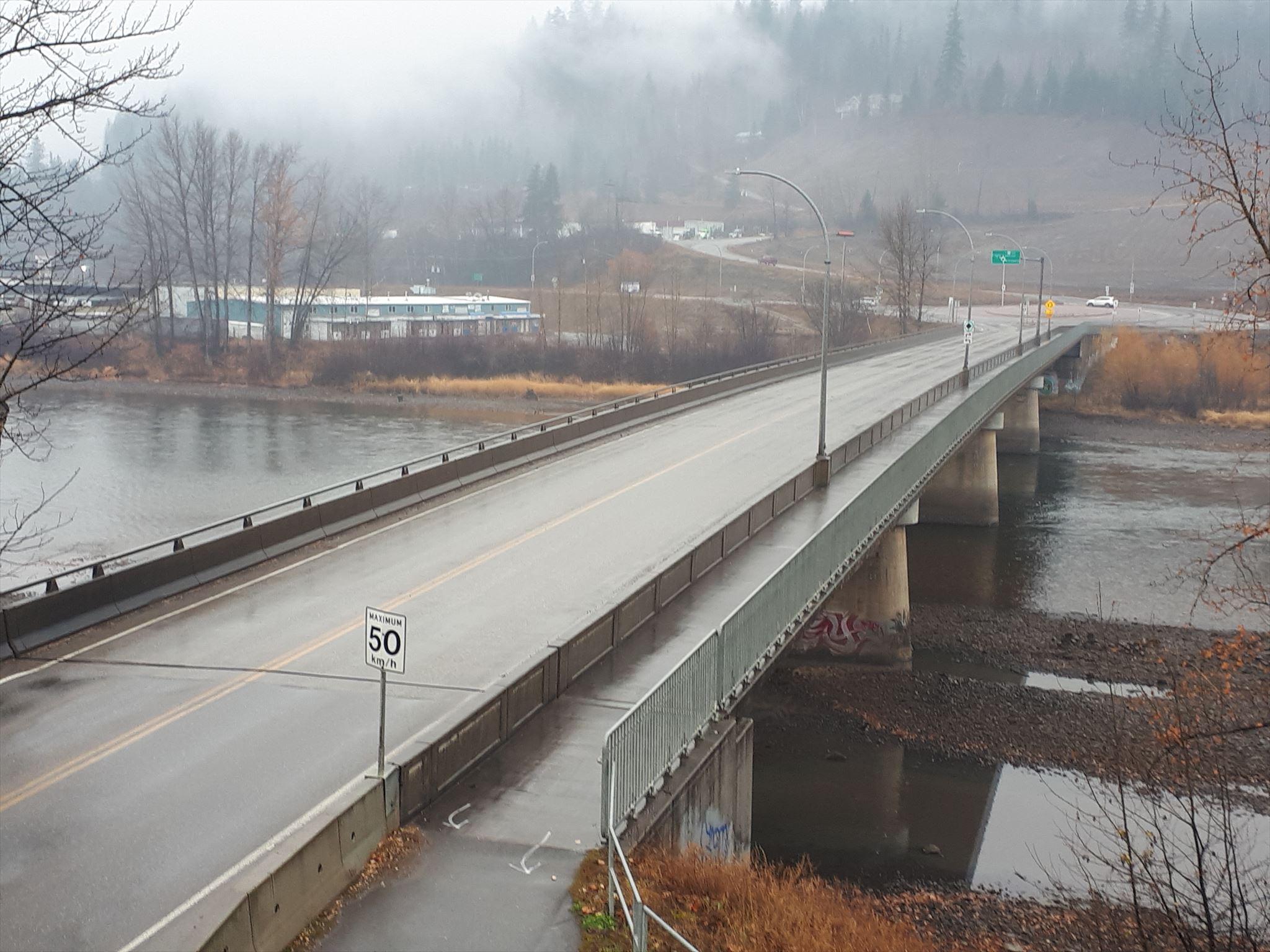
Own work. Taken Nov. 03, 2019.
The crossing plays a fundamental role in the early development of Prince George, as this river crossing connected Central Fort George with the river-routes that allowed exploration of the North. This river crossing opened up a safe access route to the trade routes expanding along the Crooked River and Parsnip River, as well as the Findlay River, and opened up the Peace River, Arctic and Pacific Watersheds (ibid). The location was geographically ideal, allowing a safer crossing than along the faster Fraser River downstream, while starting in the bowl area of the city which permitted easy access (ibid).
As the railroad increased and the sternwheelers decreased their influence, the City of Prince George became a hub for transportation of goods and services to the north and west, and the crossing later facilitated the development of the Hart region of Prince George, until the 1961 building of the John Hart Bridge (ibid).
Interestingly, the City of Prince George has never had a Cameron Street. The location of the crossing was originally in the community of Central Fort George, which was separate and distinct from Prince George. The street connecting to the crossing was known as Cameron Street in Central Fort George; however, in 1953, Central Fort George joined the City of Prince George. Cameron Street was renamed to the City of PG name - First Avenue. The name of the bridge, however, retains the original Central Fort George name (Williams, Bridge name mystery a piece of history, Oct. 6, 2014).
The crossing ran from 1910 to 1921 as a cable-ferry, also known as a reaction ferry and was known as the Nechako Ferry (Prince George Heritage Register, date unknown). The photo below is taken of one of the Heritage Plaque markers along the trail.
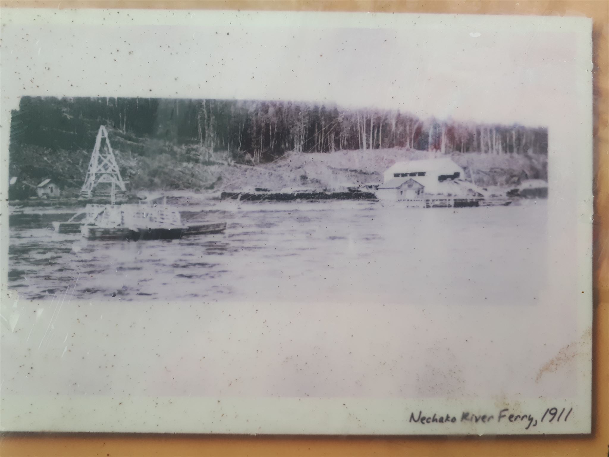
Own work. Taken Nov. 03, 2019.
The first Nechako Bridge operated from 1921 to 1931, and was located on wooden piers. The bridge had a swinging wooden section to allow for boat traffic along the river (ibid).
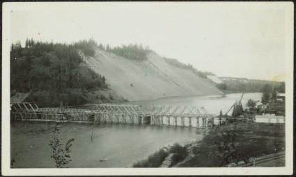
Taken from Northern BC Archives and Special Collections under fair use policies.
After an ice jam destroyed the wooden swing bridge in 1931, the first Cameron Street Bridge was built. Concrete piers were installed, and the bridge built on the piers is a classic example of a wooden Howe truss bridge, shown in the image below. (Prince George Heritage Register, Date unknown.) Vehicle traffic across the bridge was single-lane alternating, using a stoplight at either end to regulate the flow of vehicles across the bridge deck.
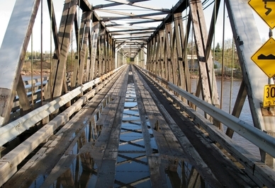
Taken from https://en.wikipedia.org/wiki/Cameron_Street_Bridge#/media/File:Old_Cameron_Bridge.jpg under a non-commercial Creative Commons license.
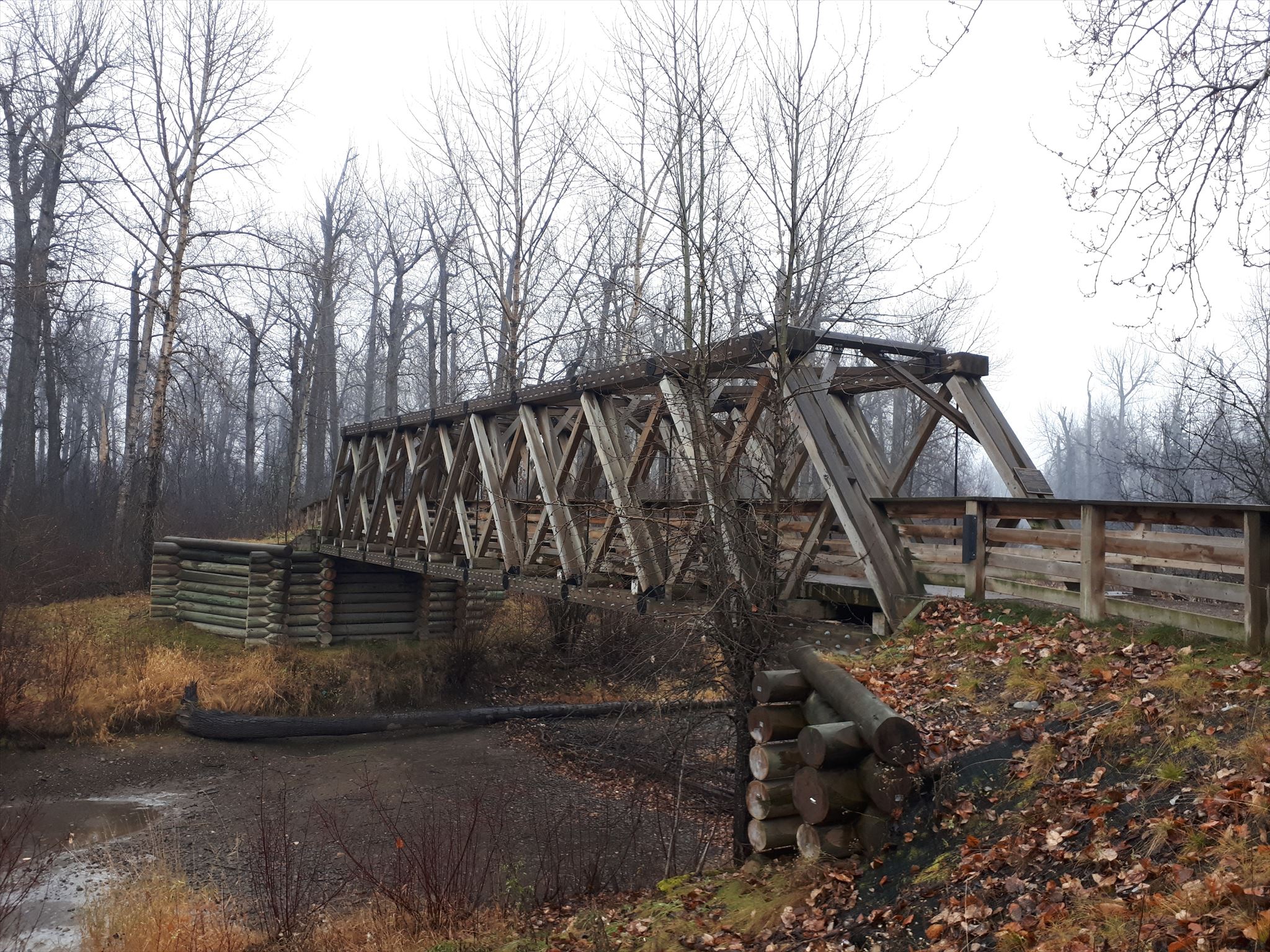
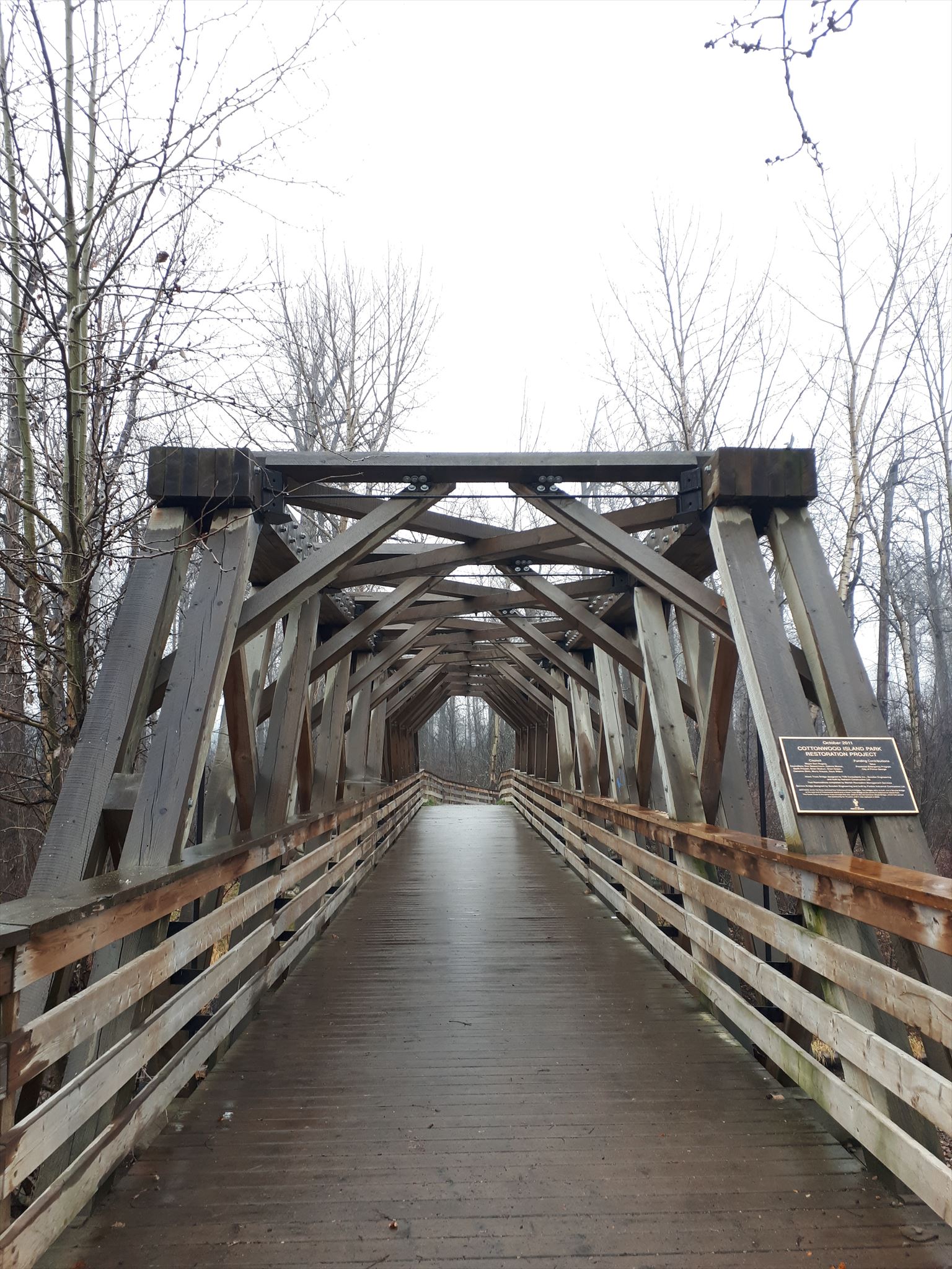
Deterioriation of the bridge trusses was discovered in 2005, which led to the closure of the bridge and the demolition of the wooden truss structures by 2008 (ibid.) By August 2009, construction was completed using steel girders and the new Cameron Street Bridge was built on the same concrete piers. (ibid.) However, the unique design of the bridge caused the City of Prince George to examine different ways to preserve the bridge, such as making the bridge a pedestrian-only bridge (Wikipedia, Oct. 29, 2019). Ultimately, the City decided to replace the bridge with the new structure seen here today; however, a replica Howe truss bridge was built to preserve the memory of this bridge and design. This bridge is located at Waypoint #3, in Cottonwood Island Park (ibid).
Question #1 - The photo at this location shows the ferry near what at the end of where?
Waypoint #2 - Foley's cache - N 53° 55.593' W 122° 44.950'
In 1913, a dock was built at this location for paddlewheelers. The company of Foley, Welch & Stewart built two paddlewheel steamboats at this dock - the Conveyor and the Operator, as well as providing a mooring point for other steamboats such as the Chilcotin. These steamboats acted as the primary means of transporting materials through the region before the railway was complete. Barges from Tete Jaune Cache brought supplies from the end of the railroad to the confluence, which the steamboats then could tow up the Nechako, or steamships carried materials directly up the Fraser from below the Fraser Canyon. The handful of posts and the retaining wall are all that remains of the dock built for these massive ships.
Question #2 - Docks, warehouses and what became known as Foley's Cache?
Waypoint #3 - Replica of Old Cameron Street Bridge - N 53° 55.394' W 122° 43.895'
Own work. Taken Nov. 03, 2019.
The replica of the Old Cameron Street Bridge was built as part of a renovation project for Cottonwood Island Park. During the 2007-2008 winter, ice flows through Cottonwood Island Park destroyed or damaged five of the bridges in the park (Evelyn, 2011). Working with the Heritage Commission, the City of Prince George made the replica bridge the centerpiece of the redevelopment of Cottonwood Island Park (ibid). A truss from the original bridge has been preserved at the adjacent Central BC Railway and Forestry Museum (ibid).
Question #3 - When was funding and resources provided to build the first bridge crossing, and how long had Prince George been a city?
Waypoint #4 - Prince George CNR Bridge (Grand Trunk Pacific Railway Bridge) - N 53° 55.007' W 122° 43.213'
Built by the Grand Trunk Pacific Railway in 1914, the completion of this bridge led to the founding of City of Prince George near the fur trading post of Fort George. (Wikipedia, Oct. 27, 2019)
Considered one of the most significant historic bridges at both the local and national level by historicbridges.org, the Grand Trunk Pacific built bridge is the only example of this engineering design in Canada, and one of only two remaining in North America (Historicbridges.org, 2013). Only four were ever built, with three in US and this one in Canada (ibid). The design is a multi-span through truss bridge, with the truss style being comparable to the old Cameron Street Bridge style. The length of the bridge makes the bridge significant. With one main span and 12 approach spans covering a total length of over 810 meters, this bridge is the longest bridge railway in British Columbia (Elder, 2014).
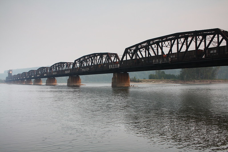
Image taken from cmh2315fl. (Aug. 16, 2010). Historic Grand Trunk Railroad Bridge over the Fraser River in Prince George, British Columbia. Used under a Creative Commons access license.
However, the vertical lift span in the middle is what makes the bridge truly unique (Historicbridges.org, 2013). The vertical lift span makes use of a specialized trapezoid-designed arm with a counterweight balance, so that when released, the counterweight pivots downward, causing the centre span to lift vertically upwards, allowing river traffic to pass under the bridge. Using the trapezoidal arms eliminated the tall towers and cabling systems required in other direct vertical lift systems (Historicbridges.org, 2013).
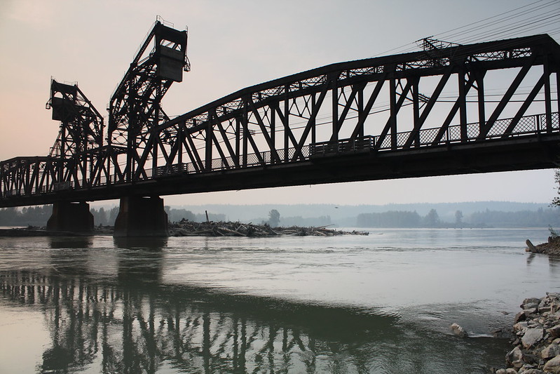
Image taken from cmh2315fl. (Aug. 16, 2010). Sunset at the Historic 1914 Grand Trunk Pacific Bridge in Prince George, BC, Canada Used under a Creative Commons access license.
Historicbridges.org notes the design of the vertical lift structure is that of Joseph Strauss, an American movable bridge engineer who invented and patented this design on Sep. 10, 1912, shortly before this bridge was built (Historicbridges.org, 2013). Prince George columnist Jeff Elder points out the bridge was designed by French engineer Joseph Legrand, citing the notes of bridge historian David Davies, whose research included Legrand's personal notebook. (Elder, 2014).
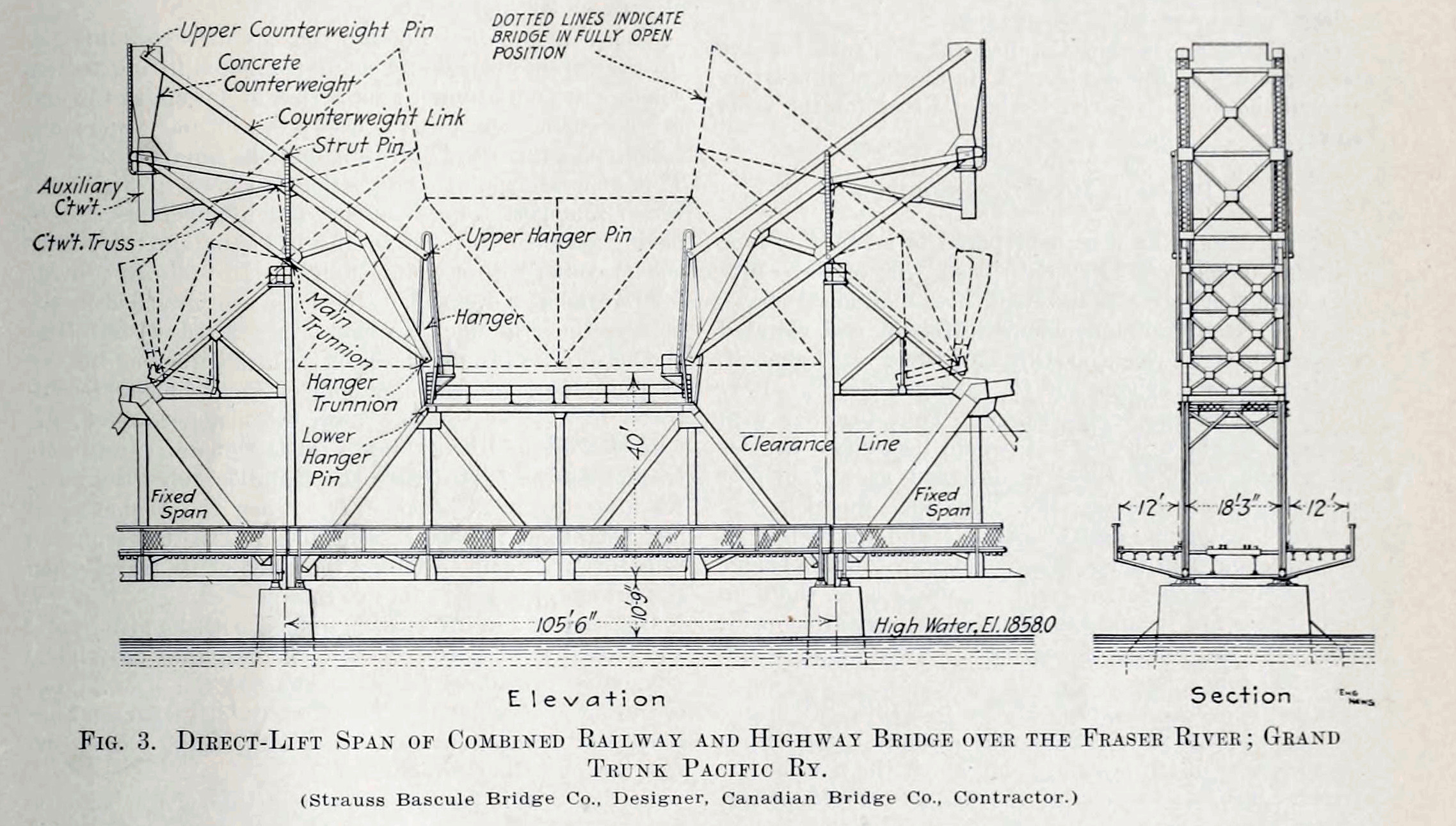
Image obtained from historicbridges.org. Used with permission.
The vertical lift was required to allow sternwheeler boat traffic access upriver, as at the time of building in 1914, sternwheeler ships still used the river. From 1863 until 1921, sternwheelers traveled up the Fraser and Nechako Rivers, requiring access under the Grand Trunk Pacific Railway bridge (Wikipedia contributors, Feb. 13, 2017). Ironically, one of the cargos of the sternwheelers was supplies for building of the railroads which ultimately made the sternwheeler transport obsolete and rendering the need for the vertical lift on the bridge unnecessary.
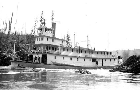
By Frank Swannell - BC Archives #I-57868[1], Public Domain, https://commons.wikimedia.org/w/index.php?curid=4016959
The Grand Trunk Pacific Railway bridge included two vehicle lanes - one on each side of the railway tracks outside the trusses, which was in use from 1915 to 1987. These lanes of traffic were closed upon completion of the Yellowhead Bridge, visible to the South (Elder, 2014). Note that the vehicle lanes are visible in the engineering imagery of the Strauss Bascule Bridge company (Historicbridges.org, 2013), and emphasized in the image below.
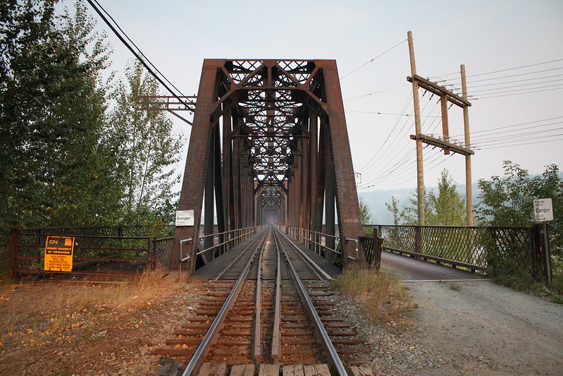
Image taken from cmh2315fl. (Aug. 16, 2010). Grand Trunk Pacific Bridge in Prince George, BC, Canada. The... Used under a Creative Commons access license.
Question #4 - How far below the riverbed do the concrete piers begin and how much do they support? - NB THIS QUESTION CANNOT BE ANSWERED AS OF SEP., 2020 DUE TO DAMAGE TO THE SIGN. PLEASE SKIP UNTIL THE SIGN IS REPAIRED.
To log this virtual cache, answer the following questions and submit the required photo. Logs without answers and the required photo will be deleted.
Question #1 - Ground Zero - The photo at this location shows the ferry near what at the end of where?
Question #2 - Waypoint #2 - Docks, warehouses and what became known as Foley's Cache?
Question #3 - Waypoint #3 - When was funding and resources provided to build the first bridge crossing, and how long had Prince George been a city?
Question #4 - Waypoint #4 - How far below the riverbed do the concrete piers begin and how much do they support? - NB THIS QUESTION CANNOT BE ANSWERED AS OF SEP., 2020 DUE TO DAMAGE TO THE SIGN. PLEASE SKIP UNTIL THE SIGN IS REPAIRED.
Also Required: Include a photo of one of the three bridges that proves you attended the location. The photo must also include a unique identifier, such as you, your GPSr unit, a trackable of yours, or a slip of paper with your name on it. If one photo is being submitted for a group, please include multiple indicators to identify each member of the group. Logs without a photo meeting this criteria will be deleted, as per geocaching.com guidelines. See https://www.geocaching.com/help/index.php?pg=kb.chapter&id=127&pgid=899.
References:
Bourchier, A. (ca 1917). Nechako Bridge, Prince George, BC. Online image. Taylor-Baxter Family Photograph Collection. Northern BC Archives and Special Collections. Accessed Nov. 06, 2019 from https://search.nbca.unbc.ca/index.php/nechako-bridge-prince-george-bc.
cmh2315fl. (Aug. 16, 2010). Grand Trunk Pacific Bridge in Prince George, BC, Canada. Online image. Grand Trunk Pacific Bridge Gallery. Accessed Oct. 31, 2019 from https://www.flickr.com/photos/cmhpictures/4946476603/in/album-72157654414379980/
cmh2315fl. (Aug. 16, 2010). Grand Trunk Pacific Bridge in Prince George, BC, Canada. The bridge was contructed in 1914 and originally carried a lane of traffic on each side of the railroad truss. The lanes are closed to all vehicles except CN Railway maintenance vehicles. Online image. Grand Trunk Pacific Bridge Gallery. Accessed Oct. 31, 2019 from https://www.flickr.com/photos/cmhpictures/4946476603/in/album-72157654414379980/
cmh2315fl. (Aug. 16, 2010). Historic Grand Trunk Railroad Bridge over the Fraser River in Prince George, British Columbia. Pictured in the haze and smoke of area summer forest fires. Online image. Grand Trunk Pacific Bridge Gallery. Accessed Oct. 31, 2019 from https://www.flickr.com/photos/cmhpictures/4946990912/in/album-72157654414379980/ .
cmh2315fl. (Aug. 16, 2010). Old traffic lane for eastbound vehicles. Online image. Grand Trunk Pacific Bridge Gallery. Accessed Oct. 31, 2019 from https://www.flickr.com/photos/cmhpictures/4947055642/in/album-72157654414379980/
cmh2315fl. (Aug. 16, 2010). Sunset at the Historic 1914 Grand Trunk Pacific Bridge in Prince George, BC, Canada. Online image. Grand Trunk Pacific Bridge Gallery. Accessed Oct. 31, 2019 from https://www.flickr.com/photos/cmhpictures/4946555287/in/album-72157654414379980/
Elder, J. (Jun. 6, 2014). Railway bridge an iconic piece of local history. Prince George Citizen. Accessed Oct. 28, 2019 from https://www.princegeorgecitizen.com/news/local-news/railway-bridge-an-iconic-piece-of-local-history-1.1131336
Evelyn, C. (Oct. 3, 2011). Cottonwood Island reno celebrated. Prince George Citizen. Accessed Nov. 02, 2019 from https://www.princegeorgecitizen.com/news/local-news/cottonwood-island-reno-celebrated-1.1082759
Historicbridges.org volunteer contributors. (2013). Prince George Railway Bridge. Accessed Oct. 28, 2019 from https://historicbridges.org/bridges/browser/?bridgebrowser=britishcolumbia/grandtrunkpacific/
Prince George Heritage Register. (Date unknown.) Prince George Heritage Register: The Nechako Crossing. Accessed Oct. 31, 2019 from https://www.princegeorge.ca/Business%20and%20Development/Documents/Heritage%20Properties/HeritageRegister_SOS_NechakoCrossing.pdf
Wikipedia contributors. (Oct. 02, 2019) Cameron Street Bridge. Wikipedia, The Free Encyclopedia. Accessed Oct. 28, 2019 from https://en.wikipedia.org/wiki/Cameron_Street_Bridge.
Wikipedia contributors. (Oct. 28, 2019) Cameron Street Bridge. Wikipedia, The Free Encyclopedia. Accessed Nov. 02, 2019 from https://en.wikipedia.org/wiki/Cameron_Street_Bridge.
Wikipedia contributors. (Jan. 18, 2018). Prince George CNR Bridge. Wikipedia, The Free Encyclopedia. Accessed Oct. 28, 2019 from https://en.wikipedia.org/w/index.php?title=Prince_George_CNR_Bridge&oldid=821115681.
Wikipedia contributors. (Feb. 13, 2017). Steamboats of the Upper Fraser River. Accessed Oct. 28, 2019 from https://en.wikipedia.org/wiki/Steamboats_of_the_Upper_Fraser_River
Williams, A. (Oct. 6, 2014). Bridge name mystery a piece of history. Published in the Prince George Citizen. Accessed Oct. 31, 2019, from https://www.princegeorgecitizen.com/opinion/columnists/bridge-name-mystery-a-piece-of-history-1.1415554
Virtual Rewards 2.0 - 2019/2020
This virtual cache is part of a limited release of Virtuals created between June 4, 2019 and June 4, 2020. Only 4,000 cache owners were given the opportunity to hide a Virtual Cache. Learn more about Virtual Rewards 2.0 on the Geocaching Blog.