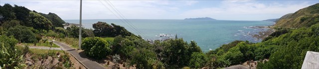
Heading north up SH1 you pass through the small sea side community of Pukerua Bay. In Maori, the words "puke rua" literally mean "two hills". As you exit the residential area and just as you're heading down to the coast, there is a nice layby area off to the side of the road. In here is a viewing platform that provides panoramic views out over the coast sweeping from north looking over Paekakariki and Paraparaumu (away in the distance), west out towards Kapiti Island and around to the south end of the Bay.
The southern terminus of the Escarpment Track is back behind you on the other side of the rail line. The Track is a popular 10-kilometre walkway, constructed as part of the national Te Araroa Trail, and links Pukerua Bay with Paekakariki to the north. The walk features stunning views of the coast and out to Kapiti Island.
Accessing the location
Parking at the lookout can only be accessed when driving north.
If you are driving south, you need to drive past the lookout and either use Te PariPari Road @170m beyond GZ or Toenga Road @315m to park in. Then it's getting back across SH1 - PLEASE be very careful of the traffic - and walking north back to the lookout. It is not recommended to turn right to cross the traffic into the parking area.
Like wise when exiting the carpark, you will need to continue north up to the Fishermans Table so as to be able to turn around and head south. It is not recommended to turn right to cross the traffic to head south.
How to qualify for a smilie  on this cache - Logging Requirements
You need to visit the location and obtain the answers to the following questions. [Questions updated 42 Mar 2025.] Please message or email me your answers. (Please DO NOT post in your found it log.) You can go ahead and log the find along with your photo but if, in my opinion, you haven't obtained the right answers or provided the answers within 5 days of logging the find then I reserve the right to remove/delete your log.
- approaching the lookout there is are some symbols which you walk over in a painted area. Please describe what you observe.
- To the left of the lookout are two information panels. In the large panel there are some words cut out, what are these words? In the small information panel "strategic gateway for ______ ______", what are the two words?
- From the lookout, take a photo of yourself and/or a personal Geocaching item and the view. Upload the photo to your ‘Found it’ log which clearly shows either yourself, your GPS or something obviously geocaching related with the view in the background. (Note: Geocaching logging requirements does not require you to display your face.) It'll be interesting seeing the different conditions the coast experiences.
After you have sent the answers to the above questions please feel free to log a smilie . If I find your answer incorrect or needs modification I will reply.
Virtual Rewards 2.0 - 2019/2020
This Virtual Cache is part of a limited release of Virtuals created between June 4, 2019 and June 4, 2020. Only 4,000 cache owners were given the opportunity to hide a Virtual Cache. Learn more about Virtual Rewards 2.0 on the Geocaching Blog.