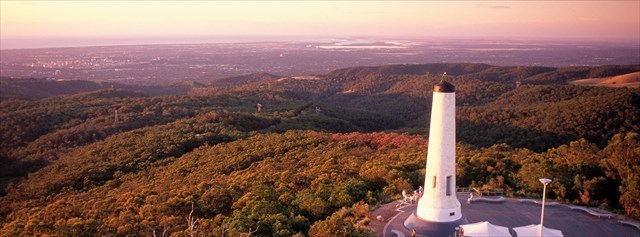
This virtual cache is at the summit of Mount Lofty, which overlooks Adelaide and some of the Adelaide plains. On a clear day you may see Yorke Penninsula and Kangaroo Island. There is car parking, a cafe, visitor centre and gift shop nearby.
Mount Lofty Ranges
Mount Lofty is the second highest peak in the Mount Lofty Ranges. The Ranges stretch from the southernmost point of the Fleurieu Peninsula at Cape Jervis northwards for over 300 kilometres before petering out north of Peterborough. In the vicinity of Adelaide, the Ranges separate the Adelaide Plains from the extensive plains that surround the Murray River.
Mount Lofty was sighted from Kangaroo Island by explorer Matthew Flinders in 1802 while mapping the southern Australian coastline. It was first climbed by a European when the explorer Collet Barker climbed it in April 1831, almost six years before Adelaide was settled.
The stringy bark forests over the back of the Mount Lofty Ranges served as a traditional boundary between the Kaurna and Peramangk indigenous people. The Kaurna regard the 50 kilometers from the Mount Lofty Ranges to Nuriootpa as the body of a giant who was killed there after attacking their tribe. The peaks of the Mount Lofty Ranges and Mount Bonython are jureidla (conserved in the toponym Uraidla), namely his "two ears".
Opening Times
The summit is open all year round, however the gates are closed late at night. See National Parks SA website for the latest information. Vehicle access gates to the car park are open at the following times:
Sunday to Thursday - 6:00am - 11:00pm
Friday and Saturday - 6:00am - 1:00am
Getting Here
By Car: There is car parking for a fee, or if you park close to the main gate there is no fee, and a 5 minute walk.
By Public transport: See Adelaide Metro website for details of buses to catch. Use the journey planner with the destination being Stop 26 Summit Rd Mount Lofty.
Hiking: If you're a keen fit walker, you can head up from Waterfall Gully for a 8km return hike. Allow 1.5 - 3 hours.
To Log This Virtual Cache
To qualify for a find you need to complete the following tasks:
1. Next to the white obelisk (Flinders Column) there are spotlights at ground level. What is the brand name embossed on the silver ring? (6 letters) Message the cache owner with this keyword.
2. Take a picture of yourself or a personal item with the view of Adelaide in the background, and attach it to your found log.
3. Optional. A plaque on Flinders Column has the elevation as 710 meters above sea level. What does your GPS say?
You may log your find immediately, however logs which do not meet requirements 1 & 2 above may be deleted.
Virtual Rewards 2.0 - 2019/2020
This Virtual Cache is part of a limited release of Virtuals created between June 4, 2019 and June 4, 2020. Only 4,000 cache owners were given the opportunity to hide a Virtual Cache. Learn more about Virtual Rewards 2.0 on the Geocaching Blog.