Salpalinja
Salpalinja on 1200 km pitkä puolustusketju Suomen itärajan tuntumassa. Se rakennettiin talvisodan jälkeen vuosina 1940–1941 ja 1944. Linja ulottuu Suomenlahdelta Jäämerelle saakka.
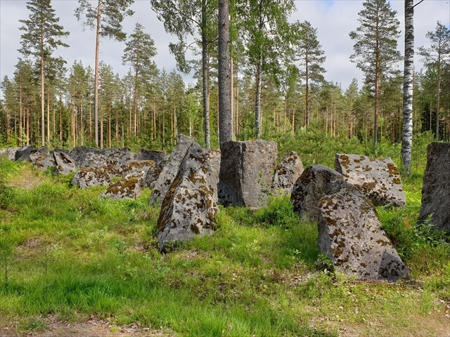
Salpalinjalle rakennettiin mm. 776 betonista tai teräksestä tehtyä linnoituslaitetta, kuten konekivääri- ja majoituskorsuja, puisia kenttälinnoitteita, taistelu- ja yhteyshautoja sekä panssarikiviesteitä. Virolahdelta, Suomenlahden rannalta Luumäen Kivijärvelle asti kivieste on lähes yhtenäinen ja suurimmalta osaltaan nelirivinen.
Salpalinja on yhä Suomen suurin rakennustyömaa. Sitä oli tekemässä enimmillään 35 000 miestä keväällä 1941 ja heitä muonittamassa oli 2 000 lottaa. Salpalinja on yksi vahvimmista ja parhaiten säilyneistä toisen maailmansodan aikaisista puolustusketjuista Euroopan alueella.
Lähteet:
Museoviraston inventointiraportti
Salpalinja museo
Tehtävä:
Parkkipaikan vieressä on 2 kohdetta, joihin on museon lupa.
- Kätkön koordinaateissa on panssarikivieste, jota Salpalinjalla on yhteensä noin 225 km. Yksi estekivi painaa keskimäärin 3000 kg ja niitä on lähes 400 000 kappaletta.
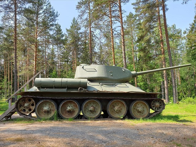
- Viitepisteessä on Panssarivaunu T-34 (-85), joka on sijoitettu Salpalinjan panssariestekivilinjan eteen kertomaan siitä, mihin tarkoitukseen estekivilinjoja rakennettiin.
Osana tämän virtuaalikätkön suorittamista varten näihin kohteisiin saa siis tutustua maksutta.
Tehtävä:
Ota kuva itsestäsi tai henkilökohtaisesta esineestäsi sekä panssarikiviesteen että panssarivaunun vieressä. Voit ottaa joko 2 kuvaa tai yhden kuvan, jossa molemmat kohteet näkyvät. Kasvojesi ei tarvitse kuvassa näkyä.
Liitä kuva(t) lokkaukseesi.
English
The Salpa Line
The Salpa Line is a 1200 km long bunker line on the eastern border of Finland. It was built after the Winter War in 1940 – 1941 and 1944. The line is stretching from the Gulf of Finland to Arctic Ocean.
The constructions of the Salpa Line consist of 776 various concrete or steel fortifications like machine gun and accommodation bunkers, wooden field installations, combat and communication trenches and 225 km of stone anti-tank obstacles - the line of stones is almost uninterrupted from Virolahti, the Gulf of Finland to Luumäki Kivijärvi.
The Salpa Line is still Finland's largest construction site. It was made by a maximum of 35,000 men in the spring of 1941, and there were 2,000 Finnish voluntary auxiliary paramilitary women helping them.
The Salpa Line is one of the strongest and the best-preserved defense lines in Europe from World War II.
References:
Inventory report of Finnish Heritage Agency
Salpa Line Museum
The task:
There are 2 objects next to the parking place with a permission from the museum.
- the cache coordinates: the stone anti-tank obstacle. There is 225 km stone anti-tank obstacles in the Salpa Line. One stone is about 3000 kg and there are almost 400,000 stones.
- the reference point: the T-34 tank, which is placed in front of the Salpa Line stone anti-tank obstacle to tell what purpose barrier lines were built.
As a part of this virtual cache, you can explore these objects without a fee.
Take a picture of yourself or your personal item by the stone anti-tank obstacle and the T-34 tank. You can take 2 pictures or just one with both objects in it. Your face does not need to be shown in the image.
Attach the picture(s) in your find log.
Virtual Rewards 2.0 - 2019/2020
This Virtual Cache is part of a limited release of Virtuals created between June 4, 2019 and June 4, 2020. Only 4,000 cache owners were given the opportunity to hide a Virtual Cache. Learn more about Virtual Rewards 2.0 on the Geocaching Blog.