Important note: This is a virtual cache. There is no physical container hidden in the village, so please do not try to look for one. When visiting the site, please help to preserve this special place by not climbing on the walls and keeping your dog on a lead. Thank you very much and I hope you enjoy your visit!
Welcome to Hound Tor Deserted Medieval Village! In this virtual cache, I will take you on a short tour of the village’s key buildings and highlight some of the fascinating archaeological evidence that provides clues about its past. There has been human activity on the site since prehistoric times, but the structures visible today have been shown to date from the 13th century. First excavated in the 1960s, they include four longhouses, three barns and four other buildings of unknown use. Much of what was originally excavated is still visible today, allowing you to walk around the very buildings that once housed a medieval community all those centuries ago.
Completing this cache will involve a walk across open moorland, which is uneven in places, and a climb up onto Hound Tor. Weather conditions on Dartmoor can change suddenly and unexpectedly, so please go prepared. Phone signal can be quite poor at the village, so make sure you save everything you need.
GETTING THERE
The easiest way to visit the village is to park at Swallerton Gate Car Park (see waypoint), from which the village is just over half a mile away. Follow the main path from the car park up onto the top of Hound Tor and through a prominent passage between two regions of the tor. As you descend down the other side, bear right and follow the wooden fence to a surfaced track, which will take you directly to the village.
LOGGING REQUIREMENTS
To log this virtual cache, please:
- Upload a photo posing in one of the buildings! Alternatively, a picture of your geopet or a piece of equipment (rucksack, GPS, etc.) is also great.
- Keeping to existing paths, head to the posted coordinates, and send me your answers to the following two questions. You don't need to wait for my reply, but please make sure you send your answers before logging a find!
QUESTIONS
The posted coordinates will take you to the remains of a porch, looking into a long, rectangular building. This is an example of a longhouse, where a medieval family would once have lived. This particular longhouse is thought to have belonged to someone of status, and is often referred to as the 'manor house'. Medieval farmers brought their animals into their homes, and so half of this house would have been devoted to a shippen (or cattle shed), with the other half forming the family's living area.
- Stand at the posted coordinates looking into the manor house (you should be facing away from Hound Tor), and see if you can spot the remains of a drainage channel. Based on its position, which side of the longhouse (L/R) would have been occupied by the medieval family, and which by their livestock?
- There is a second entrance to this longhouse, directly opposite the porch at the posted coordinates. However, this entrance is quite different to that of all the other longhouses here at Hound Tor village. Describe how.
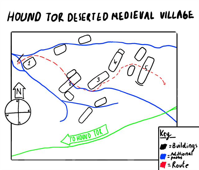
If you're interested in exploring some of the other buildings at Hound Tor village, I have written an optional short tour in the next section. To begin, head to waypoint 1, at the far western end of the village. Many thanks to my sister for her stellar work producing this village map!
TOUR OF THE VILLAGE
The route described in this section is also indicated on the above map of the village. The buildings numbered 1-5 correspond to waypoints 1-5.
The small building at waypoint 1 is not in fact a house, but rather a small barn, which would have contained a kiln, oven, and platform for drying grain. The inhabitants of Hound Tor village are known to have grown cereals, evidenced by the remains of large field systems, analysis of pollen samples, and three examples of grain-drying barns like the one here.
With the small fence behind you, follow the path around to the left of the barn, turn right and then enter the L-shaped building in front of you (waypoint 2). Just like the manor house, this is another example of a longhouse, housing both a medieval family and their animals. The passageway between the two entrances to this house would have formed the boundary between the occupant’s living area and a shippen. Indeed, you can see the remains of a drainage channel on the floor, highlighting where the shippen would have been. The house contains two further rooms – a sleeping quarters and, sticking out to make an L-shape, what is assumed to be a ‘granny flat’ to house a dependant relative. During excavations, the remains of a fallen wattle and daub chimney hood were also found in this building. Little else remains of the village’s rooves, but they are thought to have been supported by laths and wattle, and then thatched with straw.
Now leave this longhouse through the opposite door. Bear left and follow the path eastward, hugging the walls of two more longhouses (waypoints 3 and 4). It is thought that the settlement may have been built in stages, with these longhouses built after the others in order to cope with a rising population. Have a look inside. Once again, these houses would have been divided into two, with half the space used to house livestock. Indeed, excavations at waypoint 3 uncovered a significant stone drainage channel, although this is not visible today. It is difficult to imagine what it would have been like inside, but it must have been extremely noisy and smelly!
With your back to the second of these houses, a path in front of you leads between two smaller buildings and through a porch back into the manor house (waypoint 5). There are a number of clues that this house may have belonged to someone of status - it is larger and grander than the other three longhouses, and there are two small buildings within the boundaries of the garden, which are thought to have housed dependant family members, or perhaps even servants! The Lord of the Manor is often said to have lived here, though there is no direct evidence for this. If you haven't already, remember to answer the questions at this house!
WHY WAS THE VILLAGE ABANDONED?
Having explored the village, one question you may be left with is this – why did the inhabitants pack up and leave? It is impossible to precisely date their departure, but pollen evidence and analysis of the pottery found in the excavations suggest the village had been abandoned by the mid-14th century. There are different interpretations of why this happened, but it is generally thought the villagers were driven out by a change in climate, with a trend towards wetter and colder weather which made cereal production challenging. The presence of barns for drying grain certainly supports this. In addition, the devastating bubonic plague or ‘Black Death’ spread across Britain in the mid-1300s. The plague may or may not have hit Hound Tor itself, but by wiping out a third of the population it significantly changed the country’s social structure, and certainly would have opened up work on other farms down in the lowlands. Perhaps Dartmoor became just too inhospitable to be worth it.
I hope you enjoy this virtual cache! If you have time, I’d highly recommend spending a little longer at the village to soak up the atmosphere. There are several other smaller buildings to explore which are not directly featured in the tour, and archaeologists are occasionally divided over the exact purpose of each of these. There are also some great choices of walks nearby, including up onto the nearby Greator Rocks, which has some fabulous views back over the settlement.
Many thanks to the Dartmoor National Park Authority for their kind permission to place this cache in a Scheduled Ancient Monument.
BIBLIOGRAPHY
Austin, D. 1985, A New Landscape Context for Houndtor, Medieval Archaeology, No. 29.
Beresford, G. 1979, Three Deserted Medieval Settlements on Dartmoor, Medieval Archaeology, No. 23.
English Heritage 2004, Heritage unlocked : guide to free sites in Devon, Dorset and Somerset.
Newman, P., Probert, S., Riley, H. 1995 Houndtor Down – a Survey by the RCHME, RCHME, Exeter.

Virtual Rewards 2.0 - 2019-2021
This Virtual Cache is part of a limited release of Virtuals created between June 4, 2019 and December 31, 2021. Only 4,000 cache owners were given the opportunity to hide a Virtual Cache. Learn more about Virtual Rewards 2.0 on the Geocaching Blog.