lavoir

Nichée au creux de la vallée du Remontalou au sud-est du Cantal, la ville de 1 000 habitants se flatte d'être la plus méridionale des Stations Thermales d’Auvergne. Témoignage du feu ardent qui brûle les entrailles de la terre, 30 sources y jaillissent, dont la Source du Par, qui atteint 82° C, naturellement la plus chaude source d’Europe dont le débit est avoisine 18m3:h ; elle fournit à elle seule la moitié de la production d'eau de la ville
Cette ressource naturelle lui a permis de développer une activité thermale, pivot économique de la commune, mais aussi le premier réseau de chauffage urbain, mentionné dès le XIVe siècle
Chaudes Aigues et la géothermie
coupe schématique de la lithosphère au niveau de l’Auvergne

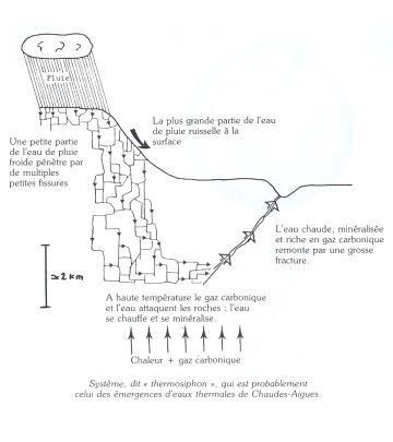
coupe géologique schématique de la région de Chaudes Aigues


.
Comment valider et loguer la cache?
Loguez cette cache "Found it" et envoyez-moi vos propositions de réponses soit via mon profil, soit via la messagerie geocaching.com (Message Center), et je vous contacterai en cas de problème.
A) 120 maisons étaient chauffées grâce à la géothermie depuis le XVè siècle, combien en restent-ils maitenant ?
B) Sur la terrasse du musée de la géothermie (a gauche)se trouve une pierre taillée : à quoi servait'elle ?
C) Expliquez pourquoi l'eau sort à cette température à Chaude Aigues
D) au lavoir:à quelle température sort l'eau ?
pour les réponces vous pouvez suivre le parcourt édité par l'office du tourisme avec ces 14 étapes et au musée de la géothermie
ENGLISH
Nestled in the hollow of the valley Remontalou southeast of Cantal, the city of 1000 inhabitants boasts of being the southernmost thermal resorts of Auvergne. Testimony of the burning fire that burns the bowels of the earth, 30 springs spring up, including the Source du Par, which reaches 82 ° C, naturally the hottest spring in Europe whose flow is close to 18m3: h; it alone provides half of the city's water production
This natural resource has allowed it to develop a thermal activity, economic hub of the town, but also the first district heating network, mentioned since the 14th century
Hot Acute and Geothermal
schematic section of the lithosphere in Auvergne
schematic geological section of the region of Chaudes Aigues
How to validate and log the cache?
Log this cache "Found it" and send me your proposals for answers either through my profile or via the messaging geocaching.com (Message Center), and I will contact you in case of problems.
A) 120 houses were heated thanks to geothermal energy since the 15th century, how many remain there now?
B) On the terrace of the geothermal museum (on the left) is a cut stone: what was it used for?
C)Explain why the water comes out at this temperature in Hot Aigues
D) at the washhouse: at what temperature does the water come out?
for the answers you can follow the route published by the tourist office with these 14 stages and the museum of geothermal energy