Welcome to the Pine Beach Trail at Bon Secour National Wildlife Refuge. To find this cache you will need to walk the trail, making observations and answering questions along the way. Your total hike will be about 3.2 miles (1.6 miles one-way) on a mostly level, hard-packed surface. However, the last ¼ mile of the trail is soft sand. Be sure you have the cache waypoints before you set out, and please be advised that completing this cache may take more than 2 hours. Start in the parking lot and answer the first question, then hike to the posted coordinates on the beach and answer the remaining questions on the way back to your car. Questions to be answered can be found in the cache description as you encounter the relevant landmarks, as well as at the bottom of this page. To log your find, message or email us your responses. Please do not put your answers in your log.
♿ If you are unable to hike the last ¼ mile of the trail (soft sand), please send an email to bonsecour@fws.gov with the subject line “Ancient Dunes Accessibility” for an alternative assignment that can be completed on your computer. Ideally, this should be completed before the rest of the cache. You will still need to visit the Pine Beach Trail at Bon Secour National Wildlife Refuge to answer questions 1, 8, and 9.
Note: This Geocache is placed by the USFWS. Please practice Cache-In-Trash-Out during your visit. We encourage you to bring a trash bag along with you on your visit and pick up any trash you may see along the way. Even this small act can make a huge difference!
Please keep the following in mind as you search for our caches:
- Please stay on the trails as you cache, you will not need to enter any closed areas during your search.
- Please do not disturb, damage, or remove any plants or wildlife. Staying on posted trails should help you to avoid disrupting our preserved natural habitat.
- The Refuge is open from sunrise to sunset. Night caching is not allowed.
- No pets are allowed on the Refuge trails or beaches.
Enjoy your adventure!
As you exit your car at the parking lot for the Pine Beach Trail, take a good look around you.
1. Describe in your own words the types of soils / ground covers (do not dig), the types of plants (size, shape, type of leaves, or names if you know them), and the shape of the land in and around the parking lot. What do you think is natural here, and what has been shaped by people?
Now hike the Pine Beach Trail to the posted coordinates on the beach.
Once on the beach at the end of the trail, turn away from the water to face the dunes.
Coastal sand dunes form as wind coming off the water (in this case, the Gulf of Mexico) pushes sand up the beach. Eventually, some of this sand begins to pile up, creating a small mound or ridge. This high area in turn causes wind hitting it to slow, depositing more grains of sand. Over time, if the area continues to build up, its elevation encourages the growth of plants that further reduce wind speeds with their leaves and anchor the sand in place with their roots. A dune is born!
Dunes are very beneficial to people and wildlife. They provide a shield from the wind, waves, and flooding associated with hurricanes and other coastal weather, and they provide resting and nesting habitat for many species of birds. Here, they are also home to the Federally endangered Alabama beach mouse. Because of the benefits dunes provide, people sometimes encourage their formation. One common method for encouraging the growth of dunes is the use of sand fencing. A fence made of thin wooden slats with gaps between is placed in a zigzag pattern along the beach. As the wind blows through this fence, it slows down and drops the sand grains it was carrying, forming a dune ridge.
2. Visually estimate the height of the first large dune ridge (waypoint W1) and describe in your own words the type of soils / ground covers, the plants, and the shape of the land that you observe here.
It's pretty tall, right? Dunes can grow this tall naturally, but the ridge at W1 was artificially enhanced with the use of sand fencing.
Now begin to hike back toward your car. As you pass the dune ridge you just examined, look around and try to determine the location of the second dune ridge. It may be harder than you think!
3. Using your GPS or another method, measure the distance between the ridge at W1 and what you believe to be the second dune ridge.
Now continue to hike until there is a noticeable change in the plants of the dunes, around waypoint W2.
4. What types of soils / ground covers, plants, and land shape do you see here? What is similar to the first dune ridge, and what is different? Why do you think the plant community has changed so much?
Now continue your hike, stopping to look around at waypoints W3 and W4.
5. Compare and contrast what you observe at these two waypoints. Be sure to notice any differences in elevation (use your eyes, not your GPS) and plant life at the two points.
Now use your GPS or another method to measure the distance between the two dune ridges near these points. Keep in mind that these waypoints are not necessarily on the ridges.
6. Now it is time to check your answer to Question 3. Compare your measurement of the distance between the dune ridges here to the measurement you took for Question 3. Do you think you correctly identified the second dune ridge? It's ok if you did not.
Now continue your hike, and notice along your way the spot where you start to see pine trees growing.
As Little Lagoon starts to come into view, stop and take a seat on the bench at waypoint W5. Think back over everything you have just observed. We hope you’ve noticed that changes in elevation and distance from the Gulf, both easily observable, can have a noticeable impact on life at the coast. However, this is not the full picture. There are other influences that affect the dunes such as wind, salt spray, groundwater beneath the surface, and occasional flooding. These other influences are harder to see and to experience in a quick hike through the dunes, but they have a major impact on dune formation and are largely responsible for the diversity of plants you have just observed.
You should have noticed that different types of plants grow at different elevations in the dunes. One major factor that causes this is occasional freshwater and saltwater flooding. It may be tempting to assume that some of these plants can grow in water and others cannot, but all dune plants require well-drained, dry, sandy soils. Rather, some plants grow faster than others and are referred to by ecologists as “pioneer species.” Pioneer species are the first to move in after a disturbance like flooding or a hurricane. When these disturbances happen often enough, slower-growing plants are never able to establish themselves in an area.
7. Which of the plants you saw in the dunes would you consider pioneer species, and why?
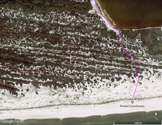
Finally, consider once again the shape of the land you saw as you hiked through the dunes. You should have seen some high ridges – straight and uniform in height – as well as low, rolling, disconnected hills. All of the changes in elevation you saw were the remains of ancient dune ridges. Notice the bands of vegetation and bare areas in the satellite image below, a great demonstration of this ancient dune ridge and trough system.
Now hike back across the lagoon and into the trees. As you begin to enter the trees, stop near waypoint W6 at the bend just beyond the observation tower.
8. You are entering a very different habitat than the one you’ve just explored. What differences do you notice here, especially in the plants and how they grow?
As you hike further away from the Gulf, saltwater plays less of a role in determining what plants are able to grow. Here, most of the water is fresh and delivered by rain. Keep going, and stop to observe waypoints W7 and W8.
9. Compare and contrast the habitats, elevations, and plant communities at these two waypoints.
Although W7 and W8 are less than 300 feet apart, the land and plant communities at these two waypoints are incredibly different. Once again, the changes in elevation you’ve witnessed are the remains of ancient coastal dunes. Even here, 1 mile from the Gulf, these ancient systems create diverse habitats allowing a multitude of plant and animal species to thrive.
We hope you’ve enjoyed learning about coastal dunes and the important habitats they create. Please visit the Refuge office or Gulf State Park to learn more about these habitats and what you can do to protect them.
Questions summarized:
1. Describe in your own words the types of soils / ground covers (do not dig), the types of plants (size, shape, type of leaves, or names if you know them), and the shape of the land in and around the parking lot (waypoint P1). What do you think is natural here, and what has been shaped by people?
2. Visually estimate the height of the first large dune ridge (waypoint W1) and describe in your own words the type of soils / ground covers, the plants, and the shape of the land that you observe here.
3. Using your GPS or another method, measure the distance between the first and second dune ridges.
4. What types of soils / ground covers, plants, and land shape do you see at waypoint W2? What is similar to the first dune ridge, and what is different? Why do you think the plant community has changed so much?
5. Compare and contrast what you observe at waypoints W3 and W4. Be sure to notice any differences in elevation (use your eyes, not your GPS) and plant life at the two points.
6. Now it is time to check your answer to Question 3. Compare your measurement of the distance between the dune ridges near W3 and W4 to the measurement you took for Question 3. Do you think you correctly identified the second dune ridge? It's ok if you did not.
7. Which of the plants in the dunes would you consider pioneer species, and why?
8. At waypoint W6, you are entering a very different habitat than the one you’ve just explored. What differences do you notice here, especially in the plants and how they grow?
9. Compare and contrast the habitats, elevations, and plant communities at waypoints W7 and W8.
Sources:
Coastal Dunes: Geomorphology - nature.com
Google Earth historical imagery
For more technical information about coastal dunes and how they form, we recommend that you also complete GC3NM64 “The Dunes of Alabama” at nearby Gulf State Park.
Created by 2019 SCA Refuge Intern Elliott Fackler, AKA facklere