Notice: "Cache seekers assume all risks and responsibilities involved in seeking this earthcache."
Warning: This is an agricultural area where many long-haul trucks full of wheat, corn, onions, potatoes, carrots, sugar beets and other commodities are busy going down the road. Most of us locals are accustomed to these trucks. If you don’t feel safe or comfortable stopping alongside the road or in a pullout to observe the geology, “Don’t Stop”. Don’t let earthcaching control you, but rather you control earthcaching. “Just because it is there, doesn’t mean you have to stop!”
“For your safety, even though the shoulder may be wide enough to stop and make observations, please park in the designated parking pullout and walk to the final. The road does get busy at times. If you feel uncomfortable with the suggested parking location, find a wider spot down the road and walk back.”
Chandler Butte
Chandler Butte at 2080 feet is located on the northern rim of the Horse Heaven Hills near the town of Kiona, Washington. It was named after G. G. Chandler who was a General Agent of the Northern Pacific railroad in 1887. The butte is part of the Yakima fold and the Columbia River Basalt Group. The Butte is an anticline fold and was created from tectonic uplift pressure some 15 million years ago.
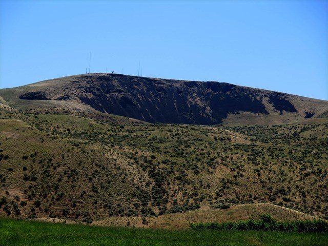
Chandler Butte: Ice Age Landslide
At the end of the last ice age, 13,000 years ago, waters eroded and undercut the northern slope of the butte from the massive glacial floods when the Lake Missoula ice dam broke. This undercut, destabilized the slope and created a translation slide (straight line without turning) to the north down to the Yakima River. From way point 1. all the distinctive features of a landslide are present.
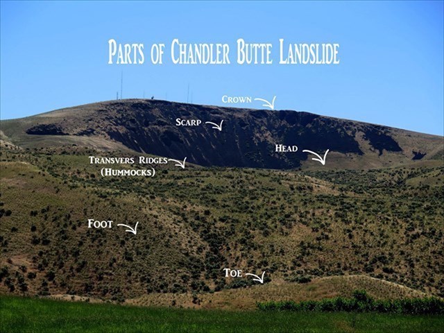
Please refer to the “Parts of Chandler Butte Landslide” image as you make your observation from waypoint 1.
Crown: The highest point where the material is displaced from.
Scarp: The steep exposed rock or soil remaining after the slide.
Head: The top of the slide below the exposed rock or soil usually flat or shelf in appearance.
Transverse Ridge: The debris mounds that cross the slide. They are also referred to as hummocks.
Foot: The portion of the slide which covers the original soil or rock surface.
Toe: These are the bulges over the ground surface at the bottom of the slide.
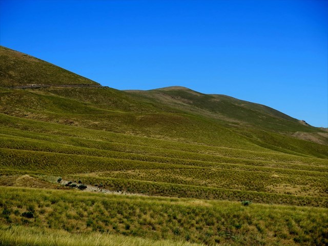
McBee: Ice Age Landslide
There are several other ice age slides east and west on the associated northern ridge of Chandler Butte. Mcbee road and slide is named after Edward McBee who had a homestead on top of the ridge in 1898. This slide is not as defined as Chandler Butte, but at waypoint 3, the center of the slide, hummocks are accessible for closer observation.
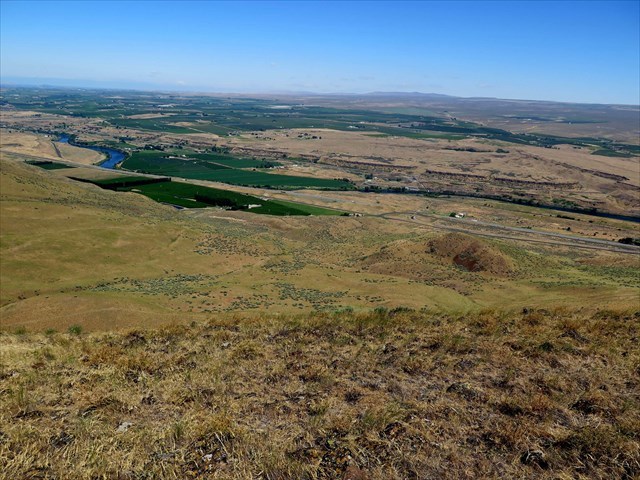
Chandler Butte: Summit and Crown
From the crown, a view of the reverse slope of the transverse ridge is available. These oblong/elongated slopes on the backside of these ridges are created from the slowing and building of the slide material on the original surface.
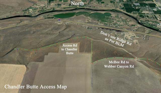
Google Earth: Chandler Butte Access Map
To access this Earthcache.
Note: An AWD, 4x4, or high clearance vehicle is recommended or hike the last 1/2 mile to summit.
1. Waypoint 1: Chandler Butte Landslide Toe
Located on W Yakitat Rd off of Interstate 82, Exit 93
2. Waypoint 2: Horse Heaven Hills BLM sign and Bottom of McBee Landside
From Kiona, WA and interstate 82 take exit 96 on to south Webber Canyon Road.
Turn west onto N McBee Road
3. Waypoint3: Center of McBee landslide
After observation continue up McBee road to the ridge. Continue on McBee Road across the ridge.
As per BLM, don’t take the short cut across the ridge road on the left at the top of ridge.
4. Waypoint 4: Access Road to BLM lands and Chandler Butte
Turn North on Access road at the provide coordinate and provided map.
5. Waypoint 5: Please park in the designated parking area
Open gate, close gate and hike to the BLM boundary sign. From this point and to stay off communication towers private land, hike north at the same elevation as you travel around the summit of the Butte to the final observation point above Chandler Butte landslide.
To Log this Earthcache.
1. At waypoint 1: Chandler Butte Landslide Toe
What is the technical term for “Hummock” as used in the description image of the parts of a landslide and describe the basalt landform in the gully south of your location.
2. At waypoint 2: Horse Heaven Hills BLM sign and Bottom of McBee Landside
How would you compare the size of the McBee landside to Chandler Butte landslide?
3. At waypoint 3: Center of McBee Landside
There are several large boulders in the area of this slide. Are any of these boulders glacial erratic or are they just local basalt (volcanic rock)? Glacial erratic are non-native rocks moved to this location by glacial icebergs and usually come from bedrock material such as granite.
4. At the posted coordinate Chandler Butte Earthcache
Are there any portions of the landslide crown or scrap visible?
Optional: Upload a photo to the page of local wildlife, unique vegetation or geology in the area.
Place by permission and conjunction of Outdoor Recreation Planner: BLM Spokane District Office Spokane Valley, Washington.
BLM provide information:
Chandler Butte and Horse Heaven Hills are a mix of public (BLM) and private lands. Visitors need to be aware of property boundaries and to avoid trespassing on private land near communication Towers and farms. Webber Canyon Road to McBee Road is the best road to access the east side of Chandler Butte and associated Ridges. Don’t access Chandler Butte across ridge road as noted on provide map. Please note that other roads in the area may not be public (BLM or county) roads, and access is by permission only. There are a number of roads and trails that crisscross BLM-managed lands on the south and west side of the Chandler Butte. Please stay on existing roads and trails and practice Tread Lightly principles:
-travel responsibly
-respect the rights of others
-educate yourself with maps and information
-avoid sensitive areas
-do your part to model appropriate behavior
For addition information on Ice Age Floodscapes, visit:
Ice Age Floods Institute
Reference Guild Book:
Bjornstad, Bruce. On the Trail of the Ice Age Floods: a Geological Field Guide to the Mid-Columbia Basin. Keokee Co. Pub., 2011.