MARMITAS DE GIGANTE EN VALDEASCAS
GARGANTA DE VALDEASCAS
A unas 2 horas de Madrid y algo menos de 1 hora de Ávila tenemos este impresionante paraje perteneciente a Navarredonda de Gredos que es una de las entradas a la llamada Plataforma de Gredos, el punto de partida de muchas rutas de senderismo por la zona.
Aunque se puede visitar en cualquier época del año, es en verano cuando más turistas atrae la garganta debido a la subida de las temperaturas y la posibilidad de poder bañarse y tomar el sol aunque también son un espectáculo en primavera por la cantidad de agua que proviene de las cumbres de Gredos, pero al bajar casi convertida en “hielo” bañarse es solo para los más valientes.
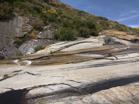
Las pozas están sobre una formación granítica que crea espectaculares saltos de agua. Estos saltos crean grandes pozas y multitud de zonas de baño junto a rocas erosionadas por el agua y el paso del tiempo.
SITUACIÓN GEOGRÁFICA
La Garganta de Valdeascas se encuentra en el pueblo abulense de Navarredonda de Gredos. El camino que parte a la garganta está junto a una zona recreativa que hay pasado el Camping de Navagredos, junto a un pinar. El coche puede dejarse en la zona recreativa para luego tomar un sendero que hay junto a una valla que remonta el río. Como a unos 15 minutos comienzan aparecer las pozas.
Por tanto, hay que dirigirse al municipio de Navarredonda de Gredos. Junto a la gasolinera parte una carretera asfaltada con una pendiente pronunciada y sinuosas curvas que nos lleva hasta el Camping Navagredos. Dejaremos estas instalaciones a nuestra izquierda. En una bifurcación de caminos, tomaremos el ramal asfaltado de la izquierda. Pasaremos junto a un antiguo molino que en época estival se convierte en bar. Unos metros más adelante veremos un área recreativa protegida por un frondoso pinar. Aquí podríamos estacionar el coche y continuar a pie, aunque también es posible acercarse hasta el Campamento de Valdeascas y dejar el coche en las inmediaciones.
Una vez estacionado el coche, continuamos a pie por una pista forestal amplia y que no entraña ninguna dificultad. Tras caminar unos 10 minutos nos encontraremos en la Garganta de Valdeascas o del Jabalí. A partir de aquí, el camino ya se convierte en un sendero estrecho señalizado por el PR-2 (Puerto de Peón) con marcas blancas y amarillas y con hitos de piedra.
El sendero va un poco alejado de las pozas y marmitas naturales que forman pequeñas piscinas naturales, pero es posible descender hasta ellas y continuar por la orilla del río. Durante todo el recorrido veremos pequeños saltos de agua y cascadas que van formando un hermoso espacio natural. Precisamente éste es uno de los principales atractivos de esta ruta donde encontraremos numerosas pozas y cascadas de aguas cristalinas, muy frecuentadas en verano para darse un buen chapuzón. Las pulidas rocas graníticas permiten utilizarlas a modo de tobogán y son muchos los que se lanzan a las pozas a través de ellas.
La mejor época para hacer esta pequeña ruta es en verano, para así poder bañarnos en las marmitas, o en primavera, fecha en la que florece el piornal, tiñendo los montes de un amarillo intenso y símbolo de la Sierra de Gredos. Es un recorrido sencillo y agradable que se puede realizar con niños de corta edad. Eso sí, cuidado con las piedras que resbalan y mucho.
Además, es el paseo ideal para completar el día después de realizar la ruta a la Laguna Grande de Gredos o la visita al Pinar de Navarredonda. ¡No os lo perdáis!
MARMITAS DE GIGANTE
La Garganta de Valdeascas está formada por rocas graníticas que se han pulido por la acción de la erosión, formando grandes lajas de piedra. Además, el agua, el viento y el hielo han excavado pozas y marmitas que son ideales para el baño en época de estío, aunque el agua está fría pero es muy limpia y cristalina.
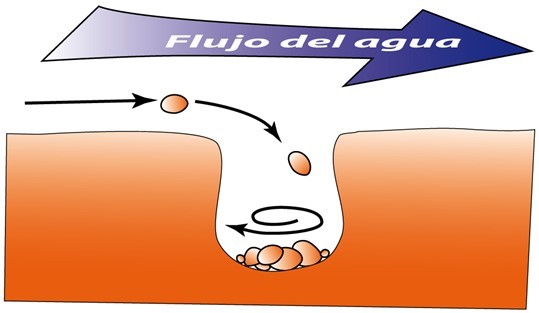
Las Marmitas de Gigante, también denominadas kettles o sumideros glaciales, son accidentes geológicos de origen fluvial que consisten en la formación de concavidades circulares debidas a la erosión producida por las piedras que arrastra el agua del río que las hace girar debido a las corrientes, horadando poco a poco el fondo del río.
Estas cavidades de forma más o menos esférica se generan cuando uno o varios fragmentos de roca quedan atrapados en algún hueco del lecho. Gracias a la acción giratoria que produce la corriente, los fragmentos golpean contra los bordes del hueco y van redondeando y haciendo más profunda la cavidad. Los fragmentos deben tener una dureza parecida o mayor que la de la roca en la que se genera la cavidad, por lo que generalmente se trata de fragmentos erosionados de la propia roca.
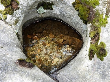
Marmita de gigante inactiva en el Alberche que nos permite ver los fragmentos de roca que la originan.
Las marmitas de gigante, que en ocasiones superan el metro de diámetro, suelen generarse en los cursos altos de los ríos, donde las corrientes tienen velocidad y energía para erosionar fragmentos de tamaño suficiente para que ejerzan como abrasivo. Además, es en los cursos altos de los ríos donde se suelen encontrar lechos rocosos con la dureza necesaria (generalmente granitos y areniscas) para que se generen estas concavidades.
El caché:
Para registrar este caché deberás contestar a las siguientes preguntas:
Cuestión 1. Explica con tus palabras qué es una marmita de gigante y cómo se forman.
Cuestión 2. ¿De qué tipo de roca están formadas las marmitas de gigante de la Garganta de Valdeascas?
Las coordenadas iniciales te sitúan delante de la zona donde se encuentran las marmitas de gigante en esta Garganta de Valdeascas.
Cuestión 3. Desde tu posición: ¿cuántas marmitas de gigante puedes ver?
Observa ahora la marmita de gigante que se encuentra más cercana a tu posición, la que se encuentra justo debajo de la formación rocosa de la siguiente foto:
Te damos las coordenadas más exactas de esta marmita por si tienes dudas: N 40º 19.438 W 005º 08.059.
Cuestión 4. ¿Qué diámetro tiene esta bien formada marmita de gigante: 3 m, 10 m o 20 m?
Cuestión 5. Observa el agua que gira en el interior de esta marmita, ¿hacia dónde gira el remolino de agua que se encuentra en su interior, en sentido horario o anti-horario?
Cuestión 6 (opcional). Hazte una foto con las marmitas de gigante de fondo y envíala junto con las respuestas a las demás cuestiones sin revelar ninguna de las respuestas a las preguntas planteadas.
IMPORTANTE: Para registrar este Earthcache, por favor, enviadnos un mensaje con las respuestas a las preguntas anteriormente formuladas. Si no se cumple esto, el log podría ser borrado. No es necesario esperar a nuestra respuesta de aprobación para hacer el “found”, pero sí es necesario enviar las respuestas.
AGRADECIMIENTOS: Muchas gracias a ASGATO por traernos con tus cachés a este precioso lugar y gracias a todos los excursionistas que nos acompañaron a la hora de idear este Earthcaché.
English version
KETTLES (GIANT POTS) IN VALDEASCAS
GARGANTA DE VALDEASCAS (VALDEASCAS GORGE)
About 2 hours from Madrid and a little less than 1 hour from Ávila we have this impressive place belonging to Navarredonda de Gredos which is one of the entrances to the so-called Plataforma de Gredos, the starting point of many hiking trails in the area.
Although it can be visited at any time of the year, it is in summer when more tourists visit this zone due to the rise in temperatures and the possibility of bathing and sunbathing, although they are also a spectacle in spring due to the amount of water that comes of the summits of Gredos, but when descending this water almost become "ice" so bathe is only for the bravest.
The pools are on a granite formation that creates spectacular waterfalls. These jumps create large pools and a multitude of swimming areas next to rocks eroded by water and the passage of time.
GEOGRAPHIC SITUATION
The “Garganta de Valdeascas” is located in the Avila town of Navarredonda de Gredos. The path is next to a recreational area (Camping of Navagredos), next to a pine forest. The car can be left in the recreational area and then take a path that is next to a fence that goes up the river. About 15 minutes later the pools appear.
So, you have to go to Navarredonda de Gredos. Next to the gas station there is a paved road with a steep slope and winding curves that takes us to Camping Navagredos. We will leave these facilities on our left. At a fork in the road, take the asphalted branch on the left. We will pass by an old mill that in summer becomes a bar. A few meters further on we will see a recreational area protected by a leafy pine forest. Here we could park the car and continue on foot, although it is also possible to get close to the Valdeascas camp and leave the car nearby.
Once the car is parked, we continue on foot along a wide forest track that does not involve any difficulty. After walking about 10 minutes we will find ourselves in the Valdeascas or Jabalí Gorge. From here, the road becomes a narrow path marked by the PR-2 (Puerto de Peón) with white and yellow markings and stone landmarks.
The trail goes a little away from natural pools and pots that form small natural pools, but it is possible to descend to them and continue along the riverbank. Throughout the tour we will see small waterfalls that form a beautiful natural space. Precisely this is one of the main attractions of this route where we will find numerous pools and waterfalls with crystal clear waters, very popular in summer to take a good dip. The polished granite rocks allow them to be used as a slide and many are thrown into the pools through them.
The best time to do this small route is in summer, so we can bathe in the pots, or in spring when the bignonia blooms, dyeing the mountains of an intense yellow and symbol of the Sierra de Gredos. It is a simple and pleasant tour that can be done with young children. But, important, be careful with the stones that slide and a lot.
In addition, it is the ideal trip to complete the day after making the route to the Laguna Grande de Gredos or the visit to Navarredonda pine forest. Do not miss it!
KETTLES OR “GIANT POTS”
The “Garganta de Valdeascas” is formed by granite rocks polished by the erosion action, forming large stone slabs. In addition, water, wind and ice have dug pools and pots that are ideal for bathing in summer, although the water is cold but is very clean and crystal clear.
The kettles or “giant pots” are geological accidents of fluvial origin that consist of the formation of circular concavities due to the erosion produced by the stones that drag the water of the river that makes them turn due to the currents, drilling little by little the bottom of the river.
These cavities of more or less spherical shape are generated when one or several fragments of rock are trapped in a hole in the bed. Thanks to the rotating action produced by the current, the fragments strike against the edges of the hole and round and deepen the cavity. The fragments must have a hardness similar to or greater than that of the rock in which the cavity is generated, so it is usually eroded fragments of the rock itself.
Giant pots, which sometimes exceed one meter in diameter, are usually generated in the upper courses of rivers, where the currents have speed and energy to erode fragments of sufficient size to exert as an abrasive. In addition, it is in the upper courses of the rivers where rocky beds are usually found with the necessary hardness (usually granites and sandstones) to generate these concavities.
The cache:
To register this cache you must answer the following questions:
Question 1. Explain with your own words what a kettle is and how they are formed.
Question 2. Of what type of rock are the kettles of the “Garganta de Valdeascas” formed?
The initial coordinates place you in front of the area where giant pots are found in this Garganta de Valdeascas.
Question 3. From your position: how many kettles can you see?
See now the kettle that is closest to your position, which is just below the rock formation in the following photo:
We give you the most exact coordinates of this kettle: N 40º 19,438 W 005º 08,059.
Question 4. What is the diameter of this well-formed kettle: 3 m, 10 m or 20 m?
Question 5. Look at the water that spins inside this kettle, where does the whirlpool of water inside it rotate, clockwise or anti-clockwise?
Question 6 (optional). Take a picture with the kettles in the background and send it along with the answers to the other questions without revealing any of the answers to the questions posed.
IMPORTANT: To log this Earthcache, please send us a message with the answers to the questions previously formulated. If this is not true, the log could be deleted. It is not necessary to wait for our approval response to make the "found", but it is necessary to send the answers.