Long Quarter Branch:
Long Quarter Branch is a stream located in Baltimore County, Maryland. It is part of the Chesapeake Bay watershed. It begins in an aquifer near Locustvale Road in Towson and feeds into Loch Raven Reservoir at N 39°25.660, W 076°35.633. It is surrounded by urban development on all sides. Long Quarter Branch is completely dependent on runoff from precipitation and an underwater aquifer. It flows south to north.
For this Earthcache, We're going to use a few simple definitions.
Sediment
Sediment is a natural material that is broken down by weathering and erosion and is transported by wind, water, or ice, and/or by the force of gravity acting on the particles. Sand and silt can be carried in suspension in river water and on reaching the sea bed deposited by sedimentation and can eventually become Sandstone or other sedimentary rock. Sediments are often transported by water but can also be transported by wind or glaciers. Beach sands and river channel deposits are examples of fluvial transport and deposition.
Types of Sediment By Size (Largest to Smallest):
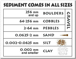
Boulders
A boulder is a rock with a size greater than 10.1 inches in diameter. While a boulder may be small enough to move or roll manually, others are extremely large and unmovable. Usually, a boulder is described to be too large for a person to move.
Cobbles
A cobble (sometimes called a cobblestone) is a rock having a particle size of 2.5–10.1 inches in diameter, or larger than a pebble and smaller than a boulder.
Pebbles
A pebble is a rock with a particle size of 0.07-2.51 inches in diameter.
Gravel
Gravel is a loose aggregation of rocks. Gravel is classified by particle size and includes size classes from granule- to boulder-sized fragments.
Sand
Sand is a natural granular material composed of finely grained rock and mineral particles. It is defined by size, being finer than gravel and coarser than silt. For the purpose of this Earthcache, we will ignore silt and clay.
Sediment Transport
Sediment transport is the movement of particles (or sediment), due to a combination of gravity acting on the sediment, and/or the movement of the fluid in which the sediment is caught. Sediment transport due to fluid motion is found in rivers, oceans, lakes, seas, and other bodies of water, due to currents and/or tides. Transport can also be caused by glaciers as they flow and on terrestrial surfaces by wind.
Stream Beds
A stream bed is the bottom of a stream, river, or creek, and is in the confine of the normal water flow. The lateral confines are known as the stream or river banks during all stages but the flood stage. Under certain conditions a river can branch from one stream bed to multiple stream beds, also known as stream or river bifurcation. A flood occurs when a stream or river overflows its banks and flows onto its flood plain (during flood stage.) The bed is the part of the channel up to the normal water line, and the banks are that part above the normal water line, hence why the “disappear” during flooding. However, because water flow varies, this differentiation is subject to local interpretation. Streambeds can range in width from a few feet for a creek, to several thousand for the largest rivers in the world. The stream bed may or may not contain flowing water at any time as some only carry water occasionally. Streambeds may cut into bedrock or through sand, clay, silt, or other unconsolidated materials commonly resulting from earlier stream depositions.
Beds are usually what is left once a stream is no longer running and the beds are usually well preserved even if they get buried because the walls made by the stream are usually hard walls while soft sand and debris usually fill the bed. Dry stream beds are also subject to becoming underground water pockets, or buried stream beds, and flooding by heavy rains and water rising from the ground and may sometimes be a huge part in the rejuvenation of a stream.
Erosion
In geology erosion is the action of surface abrasion, such as water flow or wind, that removes soil, rock, or other dissolved material from one location on the Earth's crust, and then transports it to another location, which is not to be confused with weathering which involves no movement of material. This process is caused by the activity of erosive agents like water, ice and glaciers, snow, wind, etc. In accordance with these agents, erosion is sometimes divided into glacial erosion, water erosion, snow erosion, and aeolic or wind erosion. The breakdown of rock or soil into sediment is referred to as physical or mechanical erosion. This contrasts with chemical erosion, where the soil or rock material is removed from a rock or other surface, by its dissolving into a solvent, which is usually water, followed by the flowing away of that solution. Eroded sediment may be transported just a few millimetres, or thousands of miles.
Armor
Armor is the association drawn between the of surface pebbles, rocks or boulders with stream beds or beaches. Usually armor occurs naturally, however, there is a man made form called riprap, when shorelines or stream banks are fortified for erosion protection with large boulders or sizable manufactured concrete objects. Geological modeling shows that stream armor usually sits in a flood stage environment of a stream or river. Bed armor is most often transported through entrainment, and more specifically suspension and saltation. Both of these processes involve moving the sediment near or around the bed of a river or stream. When a sediment is entrained it is being moved downstream through the forces of the water around it, and once it settles it begins to create a layer on the bed of the river or stream. This layer of sediment changes the hydrology of the river around it, and once this layer on the bottom is formed it affects the hydraulics of the river. This layer of sediments on the bed of the river can act as barrier to the incoming flow, and depending on the size and distribution of the grains, can create new legs of streams or rivers or cause the stream to otherwise meander.
How to log this Earthcache:
Any "Found It" logs without the complete requirements being sent in via email or message, will be deleted. Please answer to the best of your ability. I'm very lenient with answers as long as I can tell you actually visited the site. The GZ is in a suburban neighborhood, so please be mindful and respectful to the neighbors. Whenever possible, try to send the answers first.
1. Include the GC code of this Earthcache along with the names of all visitors. One set of answers is ok for a group, but include everyone in your group with the answers.
2. What types of sediment do you see in the stream?
3. How deep do you guesstimate the stream to be at the small pool right below you at the time of your visit? What is the predominant color of the sediments?
4. Do you think the armor in the stream is natural? Why?
5. Post a picture of yourself at the GZ. Your face doesn't need to be in the picture. You can alternatively take a picture of something that identifies you or your group (i.e. a piece of paper listing all your geo nicknames with the GZ in the background). Per the latest Earthcache guideline revision, this is no longer optional, it is now required to be able to claim your find.
Information courtesy of The Encyclopedia Brittanica; Wikipedia, and personal knowledge of geological sciences.

————————————————————————————————————————————————————
Just to clear the air: yes, two Geocachers claimed the find first and met one requirement, but did not send the rest of the answers. A second cacher found and met all requirements the next day. I waited an extra day and sent one of the first finders a reminder that I needed the answers sent. I received no response. It’s not fair then that the first person to meet all requirements is not credited as FTF when he followed the rules. Hence why logs were deleted. FTF is reserved for the first finders to meet all requirement on virtual, Earthcaches and Challenge caches, not the first on site. This is why Groundspeak discourages competition for FTF’s.
Please note that ALL requirements must be met per Groundspeak’s rules. Groundspeak doesn’t let me ask for answers first on new Earthcaches, which would solve the problem, so I will wait as much as 48 hours to receive your answers. But I do delete logs for those who don’t meet requirements and this is clearly stated on the Earthcache page. I don’t want to be the bad guy and delete anyone’s log, but if I’m forced to then I have no choice. Please understand that cache owners are responsible for keeping the integrity of the cache. That sometimes means we have to wear the black hat when all we do is keep things fair to everybody.