.
.
¿Qué es y cómo se forma un acantilado?
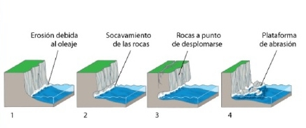
Diremos que un acantilado es un accidente geográfico caracterizado por presentar una pendiente o vertical pronunciado, casi siempre se encuentran conformados por rocas muy resistentes a la erosión, como son las rocas sedimentarias. Se originan debido a la acción erosiva de las olas, las que van socavando la base del terreno. El material de la base va dando origen a una “muesca” o caverna que desestabiliza las partes superiores del acantilado, que terminan cayendo y así este va retrocediendo. Los factores abióticos para su formación son entre otros: la fuerza de oleaje, el viento y la acción química del agua salada, que destruyen y desgastan la roca.
.
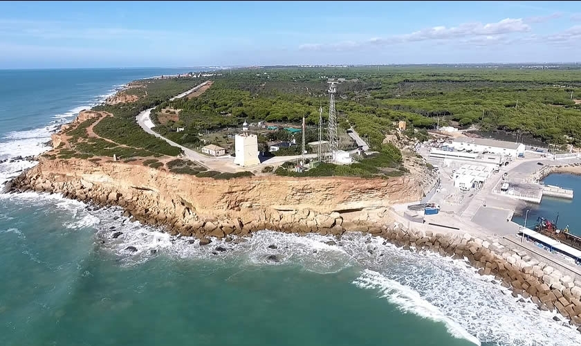
En Conil de la Frontera encontramos impresionantes acantilados desde la preciosa playa de Fuente del Gallo, hasta aproximadamente el vecino pueblo de Chiclana.
Este maravilloso litoral acantilado de forma bastante uniforme es de color anaranjado o enrojecido y según la época del año puede estar interrumpido por llegadas de corrientes de agua como el río Roche, el arroyo de la Cala del Aceite, el arroyo del Quinto y el arroyo del Pradillo.
Tal y como decimos, anualmente, el mar y las lluvias socavan el acantilado, sus rocas más bajas se erosionan por los oleajes de los temporales y las rocas más cercanas caen, vuelcan o ruedan hacia las calas o playas, convirtiéndose en sedimentos que formarán nuevas arenas, en una tarea continua de hacer y deshacer, de cambio y evolución, convirtiéndose pues, los acantilados de Conil en acantilados activos.
Los estratos de la zona nos muestran su origen marino ya que podemos encontrar fósiles y estructuras sedimentarias de esta índole.
Los fósiles, todos de animales marinos, nos indican que hace 5-3 millones de años, este territorio se encontraba sumergido, aunque no a mucha profundidad, pudiendo ésta ser variable. Al parecer el Océano Atlántico llegaba más al interior de la tierra, observándose una elevación paulatina del continente hasta el Cuaternario actual, y una apertura del Estrecho de Gibraltar, que se produjo al final del Mioceno.
En cuanto a las estructuras sedimentarias nos referimos diferentes estratificaciones cruzadas, se habla de sedimentación de barra litoral o de zona de influencia de oleaje y mareas.
Detallando, observamos que la zona más completa para conocer que pasó en el Plioceno en el litoral gaditano, se sitúa cerca de Cabo Roche, entre el Faro y la urbanización del mismo nombre, se trata de un tiempo y una zona en el que el mar se retiraba y la tierra emergía.
Existen diversas zonas diferentes dentro del acantilado según su formación y estructura, encontrando desde arcillas, arenas finas bioturbadas, rodolitos, microconglomerado con pequeños cantos de cuarcitas, marmitas gigantes, fósiles pequeños, de concha fina y de medios algo profundos, etc.
Los fósiles más espectaculares y abundantes son los rodolitos, poco comunes en la península ibérica; otros fósiles que se pueden encontrar son los moluscos bivalvos, los ostréidos, los pectínidos,... También son frecuentes las colonias de briozoos, restos de caparazones de erizos, dientes de tiburón,...
Los acantilados de Conil, un paraíso para los amantes de la Geología.
.
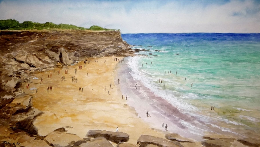
Os queremos enseñar los acantilados desde la preciosa Cala del Tío Juan Medina. Se trata de una cala en la que se pueden apreciar perfectamente todas las partes del acantilado, así como distinguir facilmente los estratos que lo forman. Recordaos antes de continuar que no debéis correr riesgos innecesarios y respetar las indicaciones en todo momento.
El caché:
Para firmar este Earth-Caché tenéis que responder a las siguientes preguntas y enviarnolas por email:
1- Al acercaros a las coordenadas, con el Atlántico a vuestra espalda y mirando hacia la izquierda. ¿Cuantas cavernas se pueden apreciar?
2- En las coordenadas, nos encontramos con una caverna, ¿qué altura dirías que tiene?
3- Los estratos del acantilado en general, ¿qué dirección presentan: horizontal u oblicua?
4- ¿Es uniforme la coloración de los estratos? ¿Donde se situan los más claros arriba o abajo?
5- En los estratos más claros se aprecia claramente un tipo de fósil que no se presenta en los oscuros, si lo conoces dinos su nombre, si no lo sabes, dinos a que se parece.
Os agradeceríamos que en vuestros registros incluyeseis una foto desde la cala (sin mostrar spoilers), o mejor aún desde el faro, que bien merece vuestra visita por las impresionantes vistas.
No es necesario esperar la respuesta del propietario para hacer "Found", una vez enviadas las respuestas, las comprobaremos y si hay algún problema, nos pondremos en contacto con vosotros.
Esperamos que os haya gustado tanto como a nosotros.
🌍🌎🌏🌍🌐🌎🌏🌍🌎
.
English Version
.
.
What is it and how is a cliff formed?
We will say that a cliff is a geographical feature characterized by presenting a steep slope or vertical, almost always are formed by rocks that are very resistant to erosion, such as sedimentary rocks. They originate due to the erosive action of the waves, which are undermining the base of the land. The material of the base is giving rise to a "notch" or cave that destabilizes the upper parts of the cliff, which end up falling and thus it goes backwards. The abiotic factors for its formation are among others: the strength of waves, the wind and the chemical action of salt water, which destroy and wear out the rock.
.
In Conil de la Frontera we find impressive cliffs from the beautiful beach of Fuente del Gallo, to approximately the neighboring town of Chiclana.
This wonderful coastal cliff is fairly uniform in color orange or red and depending on the time of year can be interrupted by the arrival of water currents such as the Roche River, the creek of the Cala del Aceite, the Quinto stream and the stream of the Pradillo.
As we say, annually, the sea and the rains undermine the cliff, its lower rocks are eroded by the waves of the storms and the nearest rocks fall, overturn or roll towards the coves or beaches, becoming sediments that will form new sands, in a continuous task of doing and undoing, of change and evolution, thus becoming the cliffs of Conil in active cliffs.
The strata of the area show us their marine origin since we can find fossils and sedimentary structures of this nature.
The fossils, all of marine animals, tell us that 5-3 million years ago, this territory was submerged, although not at a great depth, this being variable. Apparently the Atlantic Ocean reached more into the interior of the earth, observing a gradual elevation of the continent until the current Quaternary, and an opening of the Strait of Gibraltar, which occurred at the end of the Miocene.
As for the sedimentary structures, we refer to different cross-stratifications, we speak of sedimentation of the coastal bar or of the zone of influence of waves and tides.
Detailing, we observed that the most complete area to know what happened in the Pliocene on the Cadiz coast, is located near Cape Roche, between the Lighthouse and the urbanization of the same name, it is a time and an area in which the sea it retreated and the earth emerged.
There are different areas within the cliff according to their formation and structure, finding from clays, fine bioturbated sand, rhodoliths, microconglomerate with small quartzite songs, giant pots, small fossils, fine shell and somewhat deep media, etc.
The most spectacular and abundant fossils are rhodoliths, rare in the Iberian Peninsula; Other fossils that can be found are the bivalve molluscs, the ostréids, the scallops. . . There are also frequent colonies of bryozoans, remains of shells of urchins, shark teeth. . .
The cliffs of Conil, a paradise for lovers of Geology.
.
We want to show you the cliffs from the beautiful Cala del Tío Juan Medina. It is a cove in which you can perfectly appreciate all parts of the cliff, as well as easily distinguish the strata that form it. Remember before continuing that you should not take unnecessary risks and respect the indications at all times.
The cache:
To sign this Earth-Caché you have to answer the following questions and send them by email:
1- When approaching the coordinates, with the Atlantic at your back and looking to the left. How many caverns can you see?
2- At the coordinates, we find a cave, how tall would you say it is?
3- The strata of the cliff in general, what direction do they present: horizontal or oblique?
4- Is the coloration of the strata uniform? Where are the clearest up or down?
5- In the clearest strata a type of fossil can be clearly seen that does not appear in the dark ones, if you know it, tell us its name, if you do not know it, tell us what it looks like.
We would appreciate that in your records you include a photo from the cove (without showing spoilers), or better yet from the lighthouse, which is well worth your visit for the breathtaking views.
We hope you liked it as much as we did.
It is not necessary to wait for the response of the owner to make "Found", once sent the answers, we will check them and if there is any problem, we will contact you.
🌍🌎🌏🌍🌐🌎🌏🌍🌎