The lake of Tanganyika is the second largest lake in Africa and the sixt largest and second deepest lake in the world. It is located in central Africa within the countries of the Democratic Republic of Kongo, Tanzania, Saambia and Burundi. Its inflows come from Lufubu, Malagarasi and Ruzizi; its outflows go into the Lukunga. The lake has a surface of 42893 square kilometers,is 673 kilometers long, 72 kilometers wide and up to 1470 meters deep. Only the lake of Baikal contains a larger amount of fresh water. The deepness of the lake implies that fossils can be found in the lowest layers of rock.
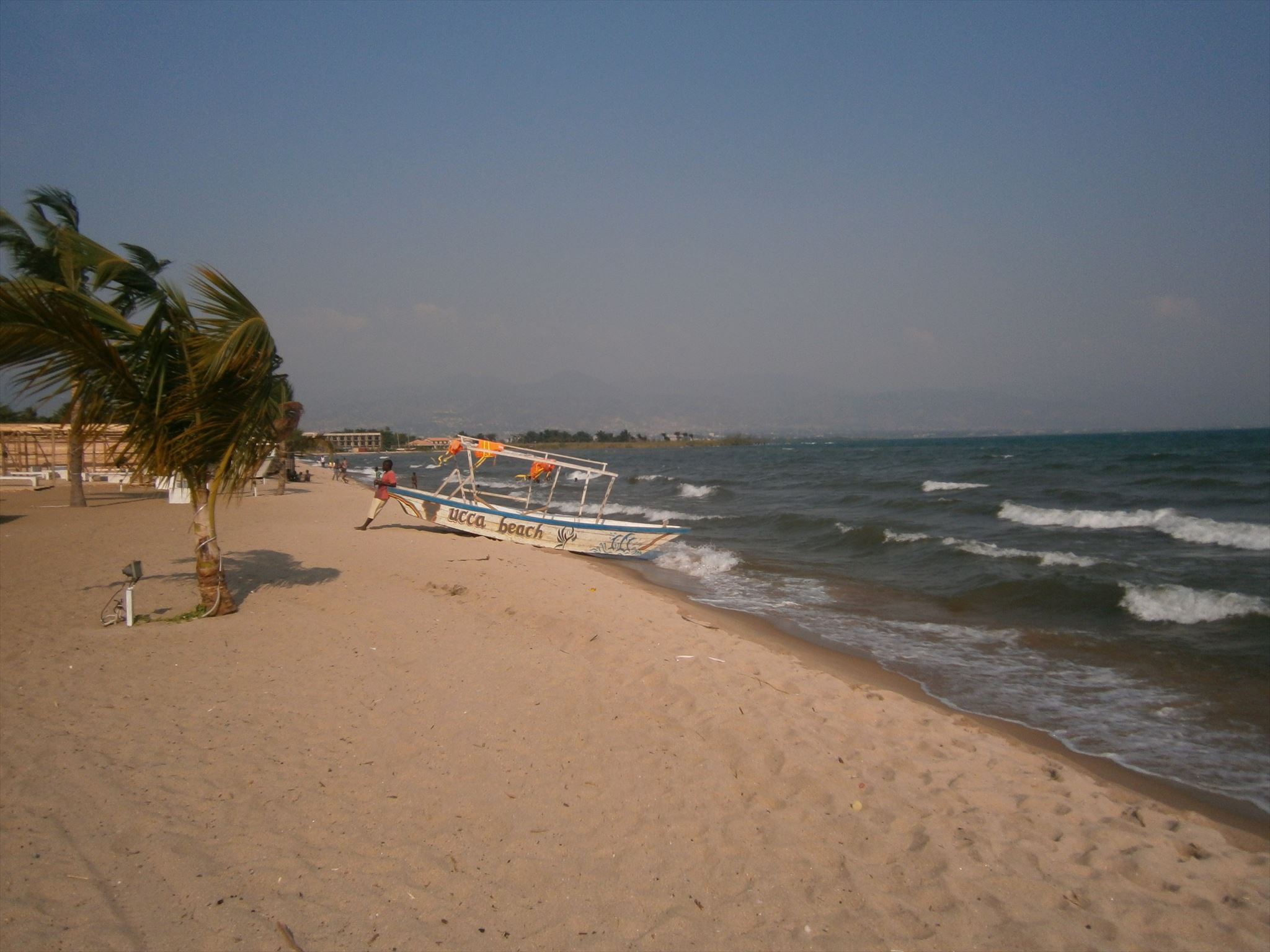
The lake of Tanganyika is the result of continental drifts; specifically the drifting apart of the east and central African plate. In the ciurse of millions of years this drift created a gigantic break, where some parts were filled with water and besame some of the oldest lakes on our planet. Continental drift, volcanos and erosion created further bizar landscapes above and under water: For some parts, the shores of the lake of Tanganyika fall hundreds of meters. At other parts, huge boulders that are up to 10 meters high can be found at the shores. Sometimes, these boulders even create whole islands. The rivers that flow into the lake left their traces and created sand surfaces that remind of the dessert. One of these sand surfaces is the subject of our excursion today.
The weathering creates rock an minerals disintegration into small particles, which leads to an increasing surface. This is a main driver for the weathering.
In general, we distinguish some kind of alteration:
- frost wedging
- rapid changes in temperature
- pressure reliefs
- salt wedging.
Contrarily, chemical weathering describes the conversion of primary minerals to secondary weathering produsts. In general, the following factors induce chemical weathering:
- solution alteration
- hydrolyse
- acid impact
- oxidation.
In general, reactions of minerals only occur on the surface of stones. Chemical weathering therefore increases with an increasing level of physical decay. This relies on the fact that the overall surface increases with a higher amount of broken pieces.
Furthermore, biological weathering describes the process of mineral and stone destruction by organisms (root wedging).
Frost wedging relies on another crucial characteristics of water. In general, water has its lowest expansion at +4 degree Celsius. From this focal point on, its expansion increases with a decrease of temperature. When freezing, water increases its volume up to 10 percent. Thus, in the case where water is filling stone cracks until 90 % of the possible volume, it will exceed the volume of the cracks. Hence, the stone pressure increases and finaly results in stone explosions. Stones and minerals which can easily be split are particularly vulnerable for frost wedging. Those are for example mica, feldspat and quarz. In combination with firm rocks, frost wedging leads to rubble, slack coal, sand, silt and coarse clay. The impact of frost wedging is particularly strong in regions with volatile changes between frost and mild temperatures.
But let's go back to the decomposition on the spot ! To describe the kind of soil you see, a simple test with your hand can already provide some insights. Take some soil (about half a fistful), spread it on your hand and make a little bit moist (not wet!). The following criteria might help you to evaluate the soil:
- granularity
- characteristics of the soil when you knead it and roll it out on your hand
Evaluation of the share of sand:
- sand grains are visible
- it crunches when rub it betweeen your hands
- it trickles in dry condition
- no lumps
- it does not stay in shape you press it in your hand
Evaluation of the share of silt:
- no grains are visible
- does not crunch ehen you rub it between your hands
- no lumps
- it does not stay in shape when you press it in your hand.
Evaluation of the share of clay:
- very sticky, in wet condition very slobbery
- the friction surface is shiny
- clumps can not be squashed in wet condition
- high plasticity in wet condition.
Moreover, the decomposition product also differs depending on its origin. If it consists mainly of volcanis rocks, a higher amount of magnetic reactions occur based on the higher share of iron. Parts of the sand are drawn on by the magnet (magnetic test). Calcareous and sedimentary deposits show a blueish till violett color under UV-light.
To log this earth cache, please send the answers to the following questions to my account. You do not need to wait for a log approval. If something is not correct, I will contact you soon.
1. Go to the listing coordiantes and do the previously described test with your hands. What are your resultats ?
2. Use the material you found to do a megnetic test. What do you see ?
3. What do you observe when you examine the material under UV-light ?
4. Use the results from question 2 and 3 to deduce the kind of original rock. What is your result ?
5. Observe the water surface in southwestern direction. Strikes the shore because of tectonic plate movement steeply sloping or are there other indication ? If yes, in which distance of meter ?
Note 24.06.2025: There is a construction site in the access area.Therefore the following information, provided thanks the last visitor, scarneck: Access from the street to the Hotel Eden at S3 21.125 E29 19.326. Passage through the wall from Eden to GZ at S3 21.256 E29 19.298. In case of flooding, alternative GZ S3 21.205 E29 19.256.
DerTanganjikasee ist der zweitgrößte See in Afrika und der sechstgrößte sowie der zweittiefste See der Erde. Er liegt in den Staaten Demokratische Republik Kongo, Tansania, Sambia und Burundi in Zentralafrika. Zuflüsse sind Lufubu, Malagarasi und Ruzizi, der Abfluss erfolgt über den Lukuga. Der See hat eine Fläche von 42893 Quadratkilometern, eine Länge von 673 Kilometern, eine Breite von bis zu 72 Kilometern und eine maximale Tiefe vob 1470 Metern. Lediglich der Baikalsee hat ein höheres Süßwasservorkommen. Die enorme Tiefe bedeutet auch, daß es sich in den tieferen Schichten des Sees um fossiles Wasser handelt.
Der Tanganjikasee ist das Produkt der Kontinentalverschiebung, also das Auseinanderdriften der ost- und der zentralafrikanischen Platte. Eine Bruchlinie von gigantischem Ausmass hat sich hier im Lauf von Jahrmillionen aufgetan, wobei sich einige Bereiche mit Wasser gefüllt haben und mittlerweile zu den ältesten Seen unseres Planeten gehören. Kontinentalverschiebung, Vulkanismus und Erosion haben über und unter dem Wasser bizarre Landschaften geformt: So fallen die Steilufer des Tanganjikasees mancherorts hundert Meter tief ab, anderswo liegen runde, bisweilen zehn Meter hohe Granitblöcke (Boulders) wie deplaziert in der Landschaft herum oder bilden ganze Inseln. In den See mündende Flüsse haben sich tief in die Landschaft gegraben, und das eingeschwämmte Sediment formt riesige Sandflächen unter Wasser und sandwüstenähnliche Küstenstreifen. Um einen solchen Küstenstreifen geht es bei unserer Exkursion.
Die physikalische Verwitterung bewirkt den Zerfall der Gesteine und Minerale in kleine Partikel, damit verbunden ist eine Vergrößerung der spezifischen Oberfläche, die eine wichtige Voraussetzung für die chemische Verwitterung ist.
Die physikalische Verwitterung wird verursacht durch
- Frostsprengung
- Temperaturwechsel
- Druckentlastung
- Salzsprengung.
Bei der chemischen Verwitterung handelt es sich um die Umwandlung von Primärmineralien zu sekundären Verwitterungsprodukten. Die chemische Verwitterung wird verursacht durch
- Lösungsverwitterung
- Hydrolyse
- Säurewirkung
- Oxydation.
Das wichtigste Element bei der chemischen Verwitterung ist das Wasser. Reaktionen und Umsetzungen des Mineralbestandes finden nur an der Oberfläche von Gesteinen statt. Die chemische Verwitterung nimmt mit Fortschreiten des physikalischen Zerfalls zu, da die Größe der Oberflächen mit zunehmender Zahl der Bruchstücke wächst. Bei der biologischen Verwitterung handelt es sich um von Organismen gelieferte Minerale und Gesteine destabilisierende Agenzien sowie Krafteinwirkung (z.B. Wurzelsprengung). Frostsprengung beruht auf einer bedeutenden Eigenschaft von Wasser. Dieses hat seine geringste Ausdehnung bei +4 Grad Celsius, während es sich bei höheren Temperaturen ausdehnt. Beim Gefrieren dehnt es sein Volumen bis zu 10 Prozent aus. Dringt Wasser in Risse oder Klüfte des Gesteins und füllt dieses zu mehr als 90 % aus, übersteigt bei Gefrieren des Wassers sein Volumen das der Hohlräume. Es kommt zu einer Erhöhung des Drucks im Gestein, bis dieses gesprengt wird. Besonders anfällig für Frostsprengung sind Gesteine und Minerale mit guter Spaltbarkeit, wie z.B. Glimmer, Feldspäte und Quarz. Aus festem Gestein entstehen dadurch Schutt, Grus, Sand, Schluff und Grobton. Eine besonders intensive Frostsprengung tritt in Regionen auf, wo es zu einem häufigen Wechsel zwischen Frost und milderen Temperaturen kommt.
Doch nun zum Ergebnis dieser Zersetzung vor Ort: Dem hier vorliegenden Boden ! Als Feldmethode zur Abschätzung der Bodenart dient die sogenannte Fingerprobe. Es wird eine nicht zu kleine Bodenprobe (etwa eine halbe Hand voll) auf der Handfläche schwach angefeuchtet (nicht zu nass!). Aus der - Körnigkeit - Knetbarkeit - Ausrollbarkeit lässt sich die Bodenart bestimmen.
Sandanteil:
- Sandkörner sind sichtbar
- knirscht beim Reiben zwischen den Fingern
- rieselt im trockenen Zustand
- keine Klumpenbildung
- angefeuchtete Handpressung möglich
Schluffanteil:
- keine Körner sichtbar
- knirscht nicht bei Reiben zwischen den Fingern
- keine Klumpenbildung
- angefeuchtete Handpressung nicht möglich.
Tonanteil:
- stark klebrig
- Reibeflächen glänzend
- Klumpen lassen sich im trockenen Zustand schwer oder gar nicht zerdrücken
- in feuchtem Zustand erhöhte Plastizität.
Auch das vorliegende Zersetzungsprodukt unterscheidet sich je nach dessen Herkunft. Handelt es sich ursprünglich um ein vulkanisches Gestein, so treten aufgrund des höheren Eisengehaltes magnetische Reaktionen auf. Teile des Sandes werden von dem Magneten angezogen (Magnetprobe). Bei kalkhaltigen, sedimetären Ablagerungen ist unter UV-Licht bisweilen eine bläuliche bis violette Verfärbung zu beobachten.
Um diesen Earthcache zu loggen sende bitte die Antworten auf folgende Fragen an mein Profil. Eine Logfreigabe braucht nicht abgewartet zu werden. Sollte etwas nicht stimmen, werde ich mich melden:
1. Führe bei den Listingkoordinaten die beschriebene Fingerprobe durch. Was sind deine Beobachtungen?
2. Mache mit einer Probe des vorgefundenen Materials die Magnetprobe. Ergebnis ?
3. Wie verhält sich das Material bei UV-Licht ? Ergebnis ?
4. Um welches Ursprungsgestein handelt es sich als Schlußfolgerung der Ergebnisse von 2. und 3. ?
5. Beobachte die Wasseroberfläche in südwestlicher Richtung. Fällt hier das Ufer aufgrund der tektonischen Entwicklung steil ab oder gibt es andere Anzeichen ? Wenn ja in wie viel Meter Entfernung ?
Hinweis 24.06.2025: Im Zugangsbereich befindet sich eine Baustelle. Deshalb folgende Hinweise Dank des letzten Besuchers scarneck. Zugang von der Straße zum Hotel Eden bei S3 21.125 E29 19.326. Durchgang durch die Mauer vom Eden zu GZ bei S3 21.256 E29 19.298. Bei Hochwasser alternativer GZ S3 21.205 E29 19.256.