Before You Begin:
Please be aware, this is a T5 earthcache, which means you will require special equipment - in this case a boat. You should expect to pay the $5 parking/boat launch fee unless you find somewhere else to put your boat in the water.
Also be advised that the D4 rating of this earthcache is based on the fact that you will be asked to make observations on site, read through the description of this earthcache for comprehension, and answer questions noted below to indicate your understanding of the topic.
Yes, this is like school. No, you don't HAVE to do any of it. But then don't log it if you don't answer, OK? Thanks.
GZ for this earthcache places you at a location in Nicomen Slough where under normal water-level conditions you will be able to make some key observations to help you understand the geology of the area, as well as the geological concepts around slough development.
What is Nicomen Slough?
From Wikipedia:
"A slough is a type of wetland, usually a swamp or shallow lake, often a backwater to a larger body of water.[Water tends to be stagnant or may flow slowly on a seasonal basis.
"In North America, "slough" may refer to a side-channel from or feeding a river, or an inlet or natural channel only sporadically filled with water."
"A slough can form when a meander gets cut off from the main river channel creating an oxbow lake that accumulates with fine overbank sediment and organic material such as peat. This creates a wetland or swamp environment. One end of the oxbow configuration then continues to receive flow from the main channel, creating a slough." 1
From the DFO's "Fraser River Action Plan":
"Nicomen Slough is a north shore tributary flowing west into the Fraser River, approximately 10km east of Mission, BC. Nicomen Slough and other sloughs in the area (i.e. Zaitscullachan Slough, Quaamitch Slough, and Mud Slough) are remnant side channels of the Fraser River. The upper ends of most sloughs are accreting and have been isolated by dykes. Most of the riparian vegetation along the dykes has been eliminated. Most of the slough flows through a broad, dyked channel across agricultural land. The mean annual flow of the Nicomen Slough is 15.65 m3/s. Excellent gravel deposits are distributed throughout the slough. However, backflooding during peak Fraser River discharges coupled with reduced flows have resulted in the deposition of a thick layer of silt over most of the slough bottom." 2
How Did Nicomen Slough Develop?
As mentioned above, Nicomen Slough is a side-channel to the Fraser River.
At some point after the last Ice Age (~20,000 years ago) the river was continuing to erode and meander through the softer depositions left behind in the Fraser Valley. During this process, the river created a number of side channels. Some became oxbow lakes some became marshland, and some became sloughs.
As a slough is created by the closing in of an old river channel and is much like the formation of an oxbow lake. The key difference is that in a slough formation there is generally a much more deposition of sediment and organic materials that cut it off from the main water source (river). Another key difference is that where an oxbow lake is formed when a significant meander of the river is "short-cut" and subsequent deposits isolate it, a slough often remains open to the original water source at one end, and may have numerous smaller tributaries, such as the case with Nicomen Slough.
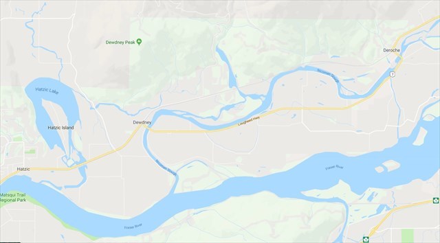
An excellent comparison of these two geological developments can be seen in comparing nearby Hatzic Lake with Nicomen Slough, in this graphic from Google Maps. You can see how the oxbow lake formation of Hatzic Lake is much more dramatically cut off from the main river than Nicomen Slough. Note that it is arguable and accepted that Hatzic Lake has not 100% completed changing from a slough to oxbow lake, but is much closer to complete oxbow lake formation, and once it has completely cut off from the Fraser it will certainly be such.
From the 1940s to the 1980s, a number of significant human interventions took place that formed the look of the slough we see today. Those included cutting the north end of the slough off from the Fraser River, industrial and agricultural developments to the land on and around the Nicomen Island area created by the slough, and the building of the dykes to manage seasonal flooding impacts.
Between thousands of years of natural forces at work, followed by a few decades of human intervention, we see before us the original side-channel slough as modified by man, and if we make some careful observations we can see the results of the original (and ongoing) geological processes.
This has created a situation where the north end of this Fraser River side-channel has accreted (slowly filled in) by a combination of man-made and natural processes. The Nicomen Slough does however have a significant number of tributaries along its length feeding water into it, which empty into the Fraser River just a short distance from the boat launch/parking coords.
The rate of flow of the water through the slough can vary seasonally due to various factors including the flood state of the Fraser River into which Nicomen Slough enters at it's south-west end, and the rate of flow of water from the multiple tributaries that empty into Nicomen Slough.
A slow rate of flow will contribute to more sediment deposition, smoother/gentler banks on the shorelines, and increased meanders. A faster rate of flow would move sediment away, cut sharper banks, and result in "straighter lines" in the path of the waterway.
Many factors, geological and human-caused have contributed to the appearance of Nicomen Slough as we see it today, but the very core and key aspects of the difference between how sloughs and oxbow lakes form are at the heart of the matter.
Here at Nicomen Slough we see the results of a side-channel losing it's upper primary connectivity to the main river source, and developing its own unique geology; observable at both macro and micro scales.
Your Tasks:
To complete this earthcache you will need to make observations per the questions below at two locations - the parking coordinates (the Nicomen Slough Boat Launch) and at the earthcache coordinates, which are approximately 4.5 km up-slough. At the earthcache coordinates you will be able to see deposition strata in the slough bank, and you should be able to lower your paddle per the instructions to estimate water depth and the texture of the slough-bottom.
Complete these tasks and submit your answers prior to logging a find on this earthcache .
Questions:
Stage 1/Boat Launch:
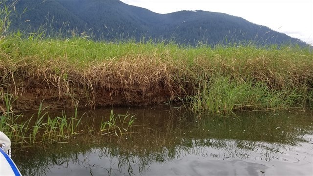
1. Describe the shoreline here, in particular the grade/angle of the shoreline relative to the water. Feel free to include mention of any vegetation or geological aspects.
2. Estimate the width of Nicomen Slough at this location.
Stage 2/Up-Slough:
3. Measure or estimate the depth of the slough at the given coordinates. On our visit we were able to do this by holding our paddle vertically until it touched bottom.
4. Describe the material at the bottom of the slough at this location, to the best of your ability - note that you may not be able to see it clearly, but you should be able to make some observations by using the vertical paddle method from question 3.
5. Observe the immediate shoreline here, and describe it. In Particular, the grade/angle of the shoreline relative to the water. Feel free to include mention of any vegetation or geological aspects. Also note the width of the slough at this location.
6. Note the shoreline (banks) stratified deposition. Estimate how many layers you can see.
7. Based on what you've learned about sloughs, and this slough in particular, provide your opinion as to why the shorelines are different at the two different locations.
8. Based on your observations, and your learnings in this earthcache description, speculate on why Nicomen Slough and Hatzic Lake formed differently - one being a slough and the other an oxbow lake.
9. *OPTIONAL* include a photo in your logs of you or your group at GZ.
References:
1. Wikipedia - Sloughs - Hydrology.
2. Lower Fraser Valley Streams Strategic Review Lower Fraser Valley Stream Review, Vol. 1
Fraser River Action Plan
Habitat and Enhancement Branch, Fisheries and Oceans Canada
360 - 555 W. Hastings St.Vancouver, British Columbia
http://www.dfo-mpo.gc.ca/Library/240006.pdf