TRADITIONAL CACHE HIDDEN ON THE SIDE OF A QUIET COUNTRY ROAD AT THE BOTTOM OF A HILL.
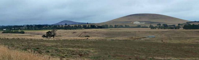
Birch Hill is a highly distinctive landscape, features a dense collection of rounded volcanic rises that are complemented and joined by numerous mullock heaps left over from the gold mining era. The area enclosed by this large site includes several large named scoria hills and cones, (Birch Hill, Mount Moorookyle, Powlett Hill, Stewart Hill & Kelly Hill, Clover Hill, Woodhouse Hill, Cattle Station Hill) and two unnamed volcanoes. It is selected as representative of the numerous smooth, steep, domal hills that are typical of the Central Hills and Plains lava fields between Creswick and Maryborough. The area lies adjacent to Mount Kooroocheang (formerly Smeaton Hill) which is treated as a separate site. This region has the highest concentration of scoria volcanoes in the Newer Volcanics Province and comprises a geological and geomorphological unit unique in Australia. The selected area lies over a deep lead system and there are strong visible reminders of nineteenth century mining endeavours in the form of shafts, mine head structures, pump houses and mine tailings (dumps). This type of mining activity was a direct consequence of the volcanism as the gold-bearing alluvial gravels had been buried by lava flows and volcanic ejecta.
SOURCE: DPCD South West Victoria Landscape Assessment Study | Significant landscapes