이곳 바닥의 암석은 왜 가마솥을 엎어놓은 것처럼 생겼을까?
이곳은 화강으로 시냇물이 흘러 들어가던 작은 계곡이 있던 곳입니다. 이곳에도 한탄강을 따라 오래전에 흐르던 용암이 흘러들어 왔었습니다. 다른 계곡의 현무암보다 더 천천히 식은 용암은 다른 지역보다 약간 더 큰 주상절리를 만들었습니다. 오랜세월 동안 하천의 물이 흐르면서 암석의 약한 사이가 먼저 깎이게 되어 지금처럼 마치 솥을 엎어놓은 듯한 모양을 가지게 되었답니다. 깎인 모양을 보면 한쪽이 더 완만한 모양을 보여줍니다. 물이 어느 방향으로 흘렀는지 알 수 있을까요?
교동가마소의 지질·지형적인 특징으로는 용암 가스튜브가 있습니다. 가스튜브는 용암이 식을 때 용암내의 가스가 용암외부로 빠져나간 통로라고 생각하시면 되는데요. 교동가마소의 현무암에서는 이러한 가스튜브가 정말 많이 보입니다. 또한 하나의 용암덩어리에서 안쪽은 괴상의 용암이고 외부는 미쳐 빠져나가지 못한 가스기공이 남아 있는 것을 볼 수 있습니다.
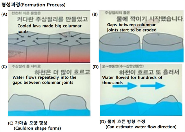
Why do the rocks on the floor look like cauldrons?
It was a small valley where streams flowed into the river. Here too, lava flowed long time ago along the Hantan River. Lava, which cooled more slowly than the basalts of other valleys, created a somewhat bigger columnar joints than any other area. For a long time, as the water of the rivers flowed, the fragile parts of the rocks were eroded first, and it became looked like cauldrons those had been turned upside down. When you look at the cut shape, one side looks more gentle. Can you tell which direction the water has been flowing?
Another geological and topographic features of the Kyodong cauldrons pond are lava gas tubes. The gas tube is a passage through which the gas in the lava flows out of the lava when the lava cools down. In the basalt of Kyodong cauldrons pond, you can oberserve a lot of gas tubes. In addition, you can observe some rocks that only one side of them have gas pockets.
[로그하는 방법]
- 이곳의 주상절리는 한탄강의 다른 지역보다 크기가 크다. (1) 그 이유는 무엇인가요? (2) 이것이 가마솥 모양의 침식과 관련이 있을까요? (3) 왜 그렇게 생각하나요? (4) 이곳 주상절리의 크기는 얼마나 되나요?
- Waypoint에 있는 암석과 주변의 다른 암석들의 침식상태를 관찰하고 (1) 물은 어느 방향으로 흘렀었는지를 판단하세요. (A에서 B 또는 B에서 A) (2) 이 암석에서 A와 B 사이의 거리는 얼마나 되나요?
- 주상절리에서 기공이 있는 부분은 용암이 식는 과정에서 깊은 안쪽에 위치했던 부분이다. (진실/오류)
- 교동가마소를 배경으로 당신 또는 당신의 GPS를 찍은 사진을 로그에 올려주세요. (선택사항이지만 사진을 올려주시기를 부탁드립니다.)
- 답을 제 Profile에 있는 메시지창을 이용해 제게 보내주세요. 이제 로그하셔도 됩니다. 답에 문제가 있을 경우 제가 메시지를 드리겠습니다.
[How to log]
- Columnar joints here are bigger than those at the other parts of Hantan River. (1) What is the reason? (2) Is this related to cauldron-shaped erosion? (3) Why do you think so? (4) What is the size of the columnar joints here?
- Observe the erosion status of the rock at Waypoints and other rocks around that! (1) Which direction did the water flow? (A to B or B to A) (2) How far is the distance between A and B in this rock?
- The part of the columnar joints with air pocket is assumed to have been formed deep inside the lava. (True/False)
- Upload the photo of you or your GPS with Kyodong cauldrons pond at the cache zone in the background! (The task is optional but I would highly appreciate if you would do so.)
- Please send the answers to me by message on my profile! You may log as 'Found'. If the answer is not correct, I will contact you.
Ref : Pocheon City
| I have earned GSA's highest level: |
 |