|
Welcome to Zanzibar. Zanzibar is an island of coral origin. They form coral limestone. Today we look to the interior of the island, where this limestone created a beautiful limestone karst cave. Welcome to the next sequel to the Geocache AGT series.
GEOLOGY CAVE
This sacred, circular cave is lined with pools so clear and still that it's hard to tell where the water begins.
Remarkably pristine pools, some more than eight feet deep, line the cave’s perimeter. The stillness of the water reflects a backdrop of stalagmites and stalactites, making it difficult to discern where the water ends and the cave wall begins.
Once the eye has adjusted, it’s possible to spot several openings that lead deeper underground. To date, these subterranean portals have yet to be explored.
Kuza Cave is a geological formation with a long, fascinating history. The Jambiani area, where the cave is located, was and still is characterized by countless underground rivers that snake beneath a relatively flat landscape. Some 250,000 years ago, the constant erosion of these underground rivers flowing between two hard layers of limestone caused the upper layer to weaken and buckle. From this collapse, Kuza Cave was born.
The new access to the revealed river created an easily accessible source of fresh water, which attracted animals and humans alike. Bones found strewn about the cave and surrounding area prove that giraffes, zebras, and waterbuck frequented it. And the marks on the bones, inflicted by sharp tools, indicate humans were present, too.
The cave has long been a sacred space for the local people. For thousands of years, they’ve journeyed to this spot within the Earth’s underbelly to hold ceremonies and pray. It’s still a place of religious worship, and is closed to the public when ceremonies are in progress. When the cave is open (which it usually is), it offers a surreal, peaceful glimpse into a wondrous underground world.
GEOLOGY ISLAND
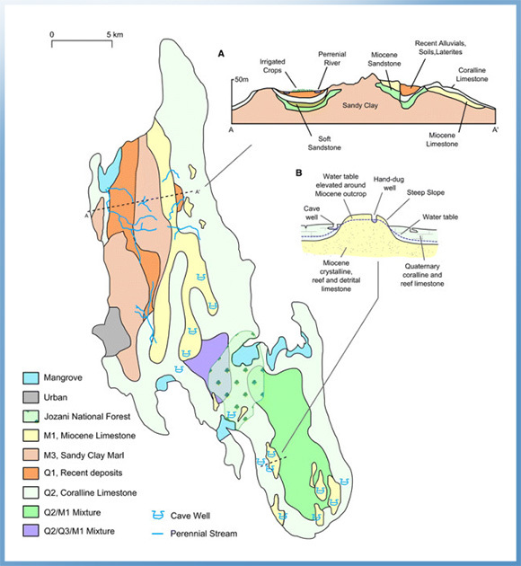
The Zanzibar archipelago, consisting of the islands of Unguja and Pemba and several surrounding islets, arepart of the ancient Miocene Rufiji/Ruvu delta. The coreof these islands consists of rocks ranging in age fromMiocene to recent clacareous sediment with limestone of marine origin that was subsequently more or lesscovered by sands, silt and clays brought by rivers fromthe East African mainland. The abundance of corallimestones on both islands is thought to indicate thepossibility that the sea might have covered much of theislands at some point in time. However, due to periods of isostatic movement and block faulting over the coastalTanzania and offshore zone these islands remainedabove sea level as blocks of the original delta.
The islands are about 40 km from the coast of EastAfrica separated by Pemba Channel on the north andZanzibar Channel on the south. Unguja Island is about 40 km south east of Pemba and about 56 km north of Latham Island or Fungu Kizimkazi, which is a small un-inhabited island also part of the Zanzibar archipelago.
Pemba Channel is much deeper and can reach up to 800m in depth off the continental shelf of the mainlandTanzania.Pemba is a simple fault block and rose earlier thanUnguja; it is thus composed of lower stratigraphic rocks,and geologically much older than Unguja.Topographically, it is a single ridge and watershed with araised east coast. It is dissected by hills and ridges andhas a marked indented western coastline with low-lyingshore and numerous marine inlets and dense mangroveforests. The highest point on Pemba Island is atSiniongoni about 90m above sea level.
Unguja Island is elongate and indented only sparselywith a stand of mangrove forests much smallercompared to that of Pemba. Believed to have emergedfrom the sea later compared to Pemba, it wasconnected to the mainland of Tanzania as late as duringthe beginning of the Pleistocene age. The topography of Unguja Island is generally flat but with a central ridgerunning from north to south whose highest point is atMasingini about 120m above sea level.
M1
Crystalline, reef and detrital limestone
Hard and dense crystalline Miocene limestone consisting of broken limestone, crushed coal,shell fragments and bands of flint. Sandy and gritty, formed as discontinuous reef, cavernousin places. Supplies water to lakes at Bambi and many springs and well, including cave wells
M3
Marls, sandy clays and clayey sands
Forms the main base rock of Unguja. Bluish grey to bluish green in colour comprising ofdense, roughly sorted Miocene chalky rocks with veins of gravel which weather to a red,yellow, or brown colour.
Q1
Soils, laterites, alluvial and colluvialdeposits
Mixture of red, brown and black Quaternary soils rich in iron oxide typical of tropicalenvironments. This fine grained soil maintains a water table forming an underground aquiferwhich provides a source of water for hillside springs.
Q2
Coralline and reef limestone
White, cream or yellow-brown Quaternary limestone which tends to be grey along rocky andjagged outcrops. Notably free from iron staining. Common across Unguja, except thenorth-eastern region, forming the island’s main underground aquifer. Frequently cavernousforming many cave wells in conjunction with M1.
Q3 Marine and fluvial sands and sandstone
Sands mixed with shell fragments, fish bones and sharks’teeth which are lightly cementedforming grey, coarse Quaternary sandstone. Provides water for pumped wells at KisimaMchanga and Cheju.
Doline
Bowl-shaped depression
Bowl-shaped closed depressions (1–1,000 m in diameter) formed by the dissolution oflimestone rocks by corrosive groundwater (carbonic acid from the reaction of water withcalcium carbonate which is abundant in limestone rocks). Fine-grained soils often drain intothese features.
Infiltration
The rate at which a soil or rock is ableto absorb water
Low infiltrating soils on Unguja are relatively fine grained, well-weathered soils typical of the Q1 geology type. Rainwater and irrigation will absorb relatively slowly into the soil helping tokeep soils saturated and retain water at the surface. Conversely, the Q2 rock type ischaracterised by high infiltration due to cracks and crevasses.
Regolith
Fine-grained weathered material
Loose, fine-grained material formed by weathering of rocks.
Terra rossa
Red clay soil
Red clay soil produced by the weathering of limestone.
Perennialstream
A river channel that runs continuouslythroughout the year
Limestone
Limestone is a carbonate sedimentary rock that is often composed of the skeletal fragments of marine organisms such as coral, foraminifera, and molluscs. Its major materials are the minerals calcite and aragonite, which are different crystal forms of calcium carbonate (CaCO3). A closely related rock is dolostone, which contains a high percentage of the mineral dolomite, CaMg(CO3)2. In fact, in old USGS publications, dolostone was referred to as magnesian limestone, a term now reserved for magnesium-deficient dolostones or magnesium-rich limestones.
About 10% of sedimentary rocks are limestones. The solubility of limestone in water and weak acid solutions leads to karst landscapes, in which water erodes the limestone over thousands to millions of years. Most cave systems are through limestone bedrock.
Limestone has numerous uses: as a building material, an essential component of concrete (Portland cement), as aggregate for the base of roads, as white pigment or filler in products such as toothpaste or paints, as a chemical feedstock for the production of lime, as a soil conditioner, or as a popular decorative addition to rock gardens.
|
|
Reef slope (Fore reef)
The reef slope is found at the outer edge of the fringing reef, closest to the open ocean. This area of the reef is often quite steep and descends either to a relatively shallow sand bottom or to depths too great to allow coral growth.
Coral grows much more abundantly on this slope, both in numbers and in species diversity. This is mostly because runoff and sediments are less concentrated here. Greater wave action disperses pollutants and carries nutrients to this area.
The upper portion of this slope is called the reef crest. The crest has the best balance between sunlight and waves, so coral grows fastest here. The base of the slope receives the least sunlight and has the least growth out of the whole slope.
Fringing reefs, which are the most common, project seaward directly from the shore, forming borders along the shoreline and surrounding islands.
The fringing reef coasts of Kenya and Tanzania, comprising platforms with bars at their ocean
margins, are modifications of a geomorphology created during the Pleistocene period by the
extensive coastal accretion and partial erosion of calcium carbonate sediments occurring now
as limestones.
The prime fringing reefs of Kenya and Tanzania are situated on coasts that are exposed to the open ocean, and where there is an insignificant discharge of terrigenous sediment from the hinterland.
In Tanzania, fringing reefs feature particularly on the eastern shores of the Zanzibar islands.
The present-day geomorphology of these reef coasts has been inherited from a long history of carbonate sedimentary development and degradation at the land-ocean boundary.
Important information
Kuza Cave has been the site of ancestor worship for thousands of years. It is, therefore, possible that access to it may be restricted due to a ceremony that’s only open to locals. However, these ceremonies are rare. On a regular basis, visitors can report to the Kuza Cave Culture Centre, which will provide a guide to the cave and a short but informative lecture on the cave. Half of the proceeds fund educational programs in the village.
Kuza Cave is about 45 minutes drive from Stonetown, or eight minutes from Paje, on Zanzibar Island in East Africa. You can take a bus (Dalla Dalla) to Jambiani and tell the driver you want to get off at Kibigija – it is after Spice Island hotel. The Dalla Dalla to Jambiani is number 309 and it leaves every hour from outside Mwanakwerekwe market.
To get here faster you could also get a Dalla Dalla for Paje, Bwejuu, or Mchamvi and get off at the big roundabout at Paje. It is eight minute taxi drive from there to Kuza Cave or you can hire bicycles and enjoy the scenery on the way.
Kuza Cave is near the first turn-off to Jambiani at Kibigija. If you are coming from Stonetown, turn right at the Kuza Cave sign at the first Jambiani turn off where there is a cement bus stop on the corner and a few shops. Follow this dirt road a few hundred metres to find Kuza Cave. You will pass an orange and white kindergarten. Then take a right to keep following the dirt road and then you will see the entrance to Kuza Cave.
|
|