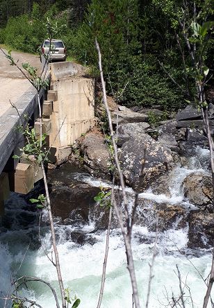
There is space for parking immediately after passing over the small bridge on this forest service road, en route to Ghost Falls and Ghost Lake. The bridge is located over Mathew River Falls. From the bridge, you will have to look straight down at the rock formation on the left hand side of the river when facing upriver.
Potholes!
Potholes go by a lot of names in geology terms. Other names for a pothole include kettle, evorsion, rock mill, churn hole, and kolk. The definition of a pothole is "a circular or cylindrical hole in the riverbed which is produced by force of water and abrasion. " (Ernstes, date unknown, Potholes) or "a smooth, bowl-shaped or cylindrical hollow, generally deeper than wide, found carved into the rocky bed of a watercourse. " (Wikipedia, Jul. 27, 2018, Pothole (landform)) Potholes can vary greatly in size, often beginning as just a couple centimeters and expanding to several meters, or combining with other pothole formations (Koh, date unknown, Potholes).
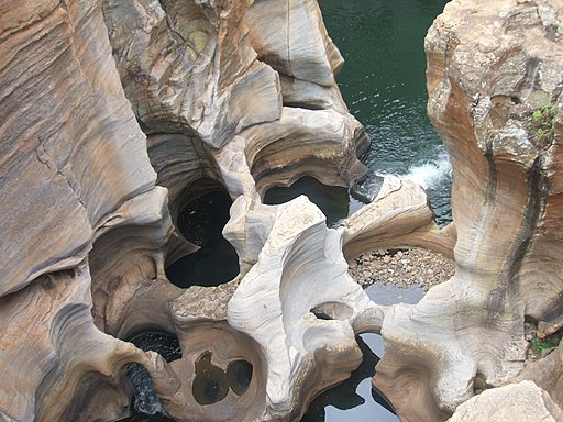
© Pierre André [CC BY-SA 4.0 (https://creativecommons.org/licenses/by-sa/4.0)]
The above image of the Motlatse Canyon shows the size of potholes that can form, including how they combine together by expanding into one another. Note the gravel and rocks visible in the bottom of one of the potholes.
There are three elements required for the formation of potholes:
1) There must be exposed bedrock in the riverbed or watercourse,
2) The water flowing in the watercourse must be turbulent, and
3) The sediment carried by the water must be harder than the underlying bedrock.
As the water flows over the bedrock, gentle indentations on the surface of the rock face collect some of the sediment from the water. Once the sediment is located in the indentation, the sediment (which is composed of small rocks, gravel, sand, etc.) cannot escape the indentation.
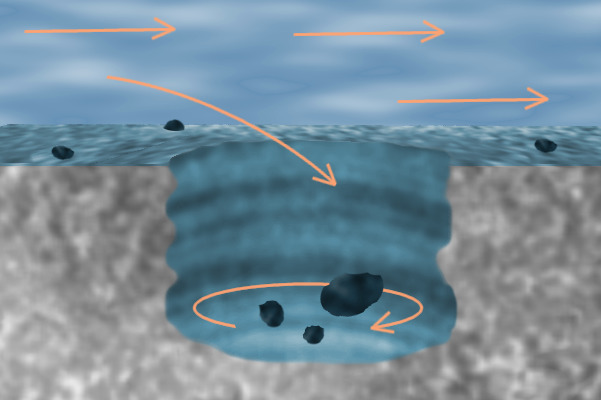
Jasmin Ros [CC0]
During high water flow times, the water runs over the indentation, now with sediment in it. As more high-energy (turbulent) water runs over the indentation with the sediment in it, the sediment, which is free to move, begins to be pushed around within the indentation. The rocks and sediment, now known as grinders, then begin to act as a sandpaper on the bedrock harboring it. As the water continues to move the sediment around, the sediment slowly begins to erode the bottom of the indentation. Over time, the wearing of the indentation will form a circular or oblong hole, as the force of the water and the sediment-sand-paper smooths out the sides as it carves its way down into the rock.
To log a find on this Earthcache, you must submit answers to the following questions, either via email or via the geocaching messaging system. Logs that do not submit answers will be deleted.
Questions:
1) Estimate the height of the water level against the foot of the Northern piling. This will help establish how much water is flowing at the time of viewing the potholes. When the earthcache was written, the water was flush with the bottom of the foot of the piling, roughly 20 feet below the bridge deck. See the photo below for comparison.
2) Estimate the diameter of the largest visible pothole.
3) How many potholes have water flowing into them when you viewed them?
4) Count how many potholes are visible.
5) Estimate the depth of the deepest pothole.
6) While not required, you are standing at an absolutely gorgeous set of waterfalls with a GPSr. Why not share a photo of your GPSr and some of the falls?
References
Ernstes, A. (Date unknown). Potholes. Accessed Aug. 10, 2019 from http://www.geo.mtu.edu/KeweenawGeoheritage/The_Fault/Potholes.html
Koh, G. (Date unknown). Potholes. Accessed Aug. 10, 2019 from http://www.angelfire.com/hero/gerald_koh_s9029362a/potholes.htm.
Wikipedia. (Updated Jul. 27, 2018). Potholes (landform). Accessed Aug. 10, 2019 from https://en.wikipedia.org/wiki/Pothole_(landform)