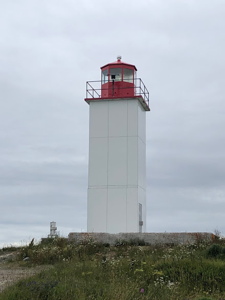
Welcome to Long Point Lighthouse, White Head Island, Charlotte County, New Brunswick.
NOTE: You can only complete this cache near low tide time so please check the tide tables: https://www.tide-forecast.com/locations/Campbellton-New-Brunswick/tides/latest. The tidal area can be muddy, so suitable footwear is recommended. To log this Earthcache, read the information below and visit the posted coordinates.
The Area
White Head Island is a Canadian island located in the Bay of Fundy. With a population of roughly 200, White Head Island is the only other inhabited island in the Grand Manan Archipelago besides Grand Manan Island. Samuel de Champlain sought shelter at White Head Island during a storm in October of 1606, but permanent settlers would not arrive for two hundred more years. This island has some amazing views and beautiful beaches but for this Earthcache, you will be looking for something on this particular beach.
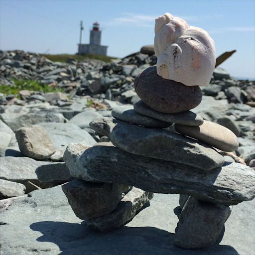
Long Point beach has an over thousand-year-old drowned forest - a broad area of preserved tree stumps still rooted in the original soil that are exposed at low tide. You might think that they are fossils considering where they are found but have a closer look!
The Geology
Some of the research for this Earthcache phenomena has been graciously supplied by a fellow geocacher, juniorwoodchuckhuey, who created the Earthcache GC62BJP -a 4000-year old forest… Many thanks for his permission to use it.
White Head Island, Gull Rock, Machias Seal Island, and North Rock are part of the larger Grand Manan archipelago. Ongoing erosion is constantly changing the shape of the archipelago (beaches, ledges, cliffs, etc.), exposing 3000-year-old tree roots and stumps in some places.
This fascinating forest of tree stumps and freshwater peat still rooted in the original soil is exposed on the seafloor at low tide. It dates from about 1500 years ago when sea level was about 3 m lower than it is today. Rising sea level continues to push back the beach, exposing more trees and eroding the seaward part. The earth's crust is subsiding throughout Nova Scotia and New Brunswick and, in practical terms, is manifest as a rapid rise of sea level.
Fossils
Fossils are the remains or traces of plants and animals that lived at least 10,000 years ago which would be the end of the Cenozoic Era and the Pleistocene Period on the geologic time scale. Most fossils are found in soil that once lay underwater. They usually formed from the hard parts, such as shells or bones, of living things. A fossil normally preserves only a portion of an organism. Trace fossils are the marks left by a living organism, such as feces, footprints or impressions of feathers or leaves. Organisms usually need to be covered by mud, sand, tar or some other sediment as soon as possible or frozen or dried out for fossilization to occur.
SubFossils
A subfossil is a bone or other part of an organism that is preserved but not fossilized. Either the conditions were not right for fossilization or not enough time has passed for it to be fossilized (less than 10,000 years). These stumps might be considered subfossils. The main difference between a subfossil versus a fossil is that the subfossil contains organic material. This material can be used to determine the age, and other identifying aspects such as DNA, proteins or other molecular processes. It is from this material, scientists can derive additional knowledge about the ecological conditions at the time as well as environment and paleoclimatology (study of changes in climate taken on the scale of the entire history of Earth).
Subfossils are often found in environments where there are sediment deposits or build up, such as lake and ocean sediments, and soils. Once deposited, physical and chemical weathering can alter the state of preservation.
Requirements to log this Earthcache
To successfully accomplish the requirements for this Earthcache visit the viewing location. Please answer the following questions and send in a timely manner to my geocaching profile or email. Answers not received will result in deleted logs. If you enjoy this Earthcache, favourite point is always appreciated. There is no need to contact me for confirmation before logging this geocache. The photo should be attached to your log. Should there be any difficulty, you will be notified.
Please only leave footprints and if you can CITO while you are there, the environment thanks you.
- Find the Drowned Forest at ground zero and estimate the size of the forest. (You can use your gps to mark a spot and walk to the other side)
- Choose a tree stump and examine it carefully. What is the average diameter? What does the soil look like surrounding it? Describe the roots of the tree. Are they smooth, rough? What colours? Are they long and straight, or wiggly and short or a variety?
- Are these tree stumps a fossil or a sub fossil? Can you explain how you can tell?
- Post a picture of yourself or GPS device with the lighthouse in the background. (As of June 10th, Groundspeak guidelines allow photos as part of the requirements.)